
Popular for different reasons, the two mountains described in this route are usually climbed individually. The Cobbler (aka Ben Arthur, 884m) is one of Scotland’s favourites for its true mountain feel and unique silhouette, while Beinn Narnain (926m) is an accessible Munro and a good place to start for those wanting to complete a round.
It’s hard to choose a favourite, so this route visits both. Starting at sea level, the initial slog up Beinn Narnain is quickly rewarded with expansive views over Loch Long and the Luss Hills. As you climb higher, the dramatic, crumbling horns of The Cobbler come into view, while the peak of Beinn Narnain itself isn’t visible until you’re nearly upon it.
The final steep, rocky ascent brings you to a large plateau at the summit of Beinn Narnain. From here you can see Beinn Ime in the northwest, Loch Lomond and the Trossachs National Park to the east, and Loch Long leading down to the sea.
After descending to Lochan a’ Chlaidheimh, a path heads up to The Cobbler. For most people, the central peak’s plateau will be quite enough, but if you’re a proficient scrambler with a good head for heights, the true summit is an exposed rocky pinnacle, which should only be tackled in dry conditions.

How hard is climbing The Cobbler?
This entire route only covers 11.4km, despite climbing two classic Scottish mountains, but the total ascent of 1240m will certainly test your stamina. The walking is only half of the story though, because you'll need to be a comfortable scrambler to complete it.
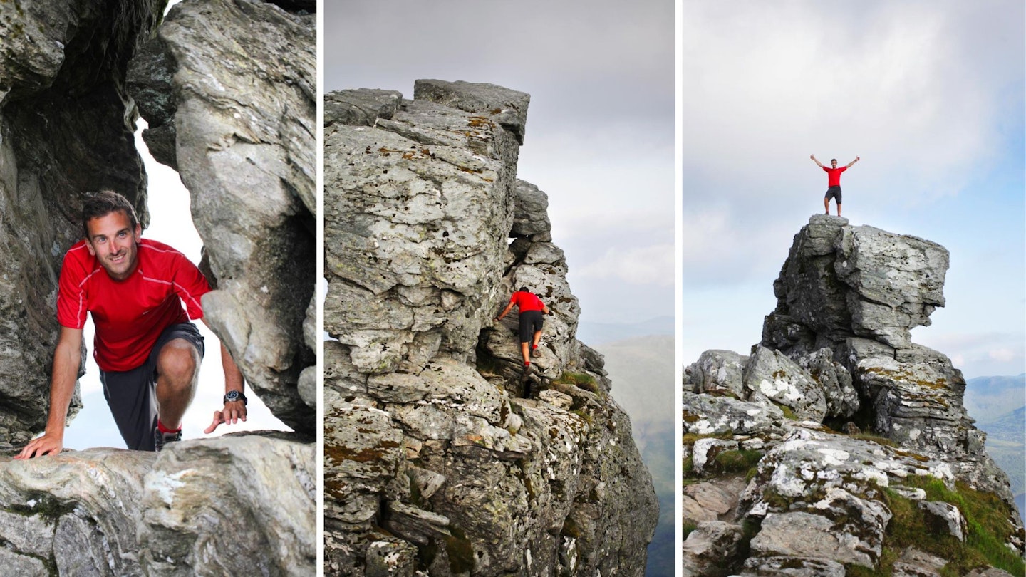
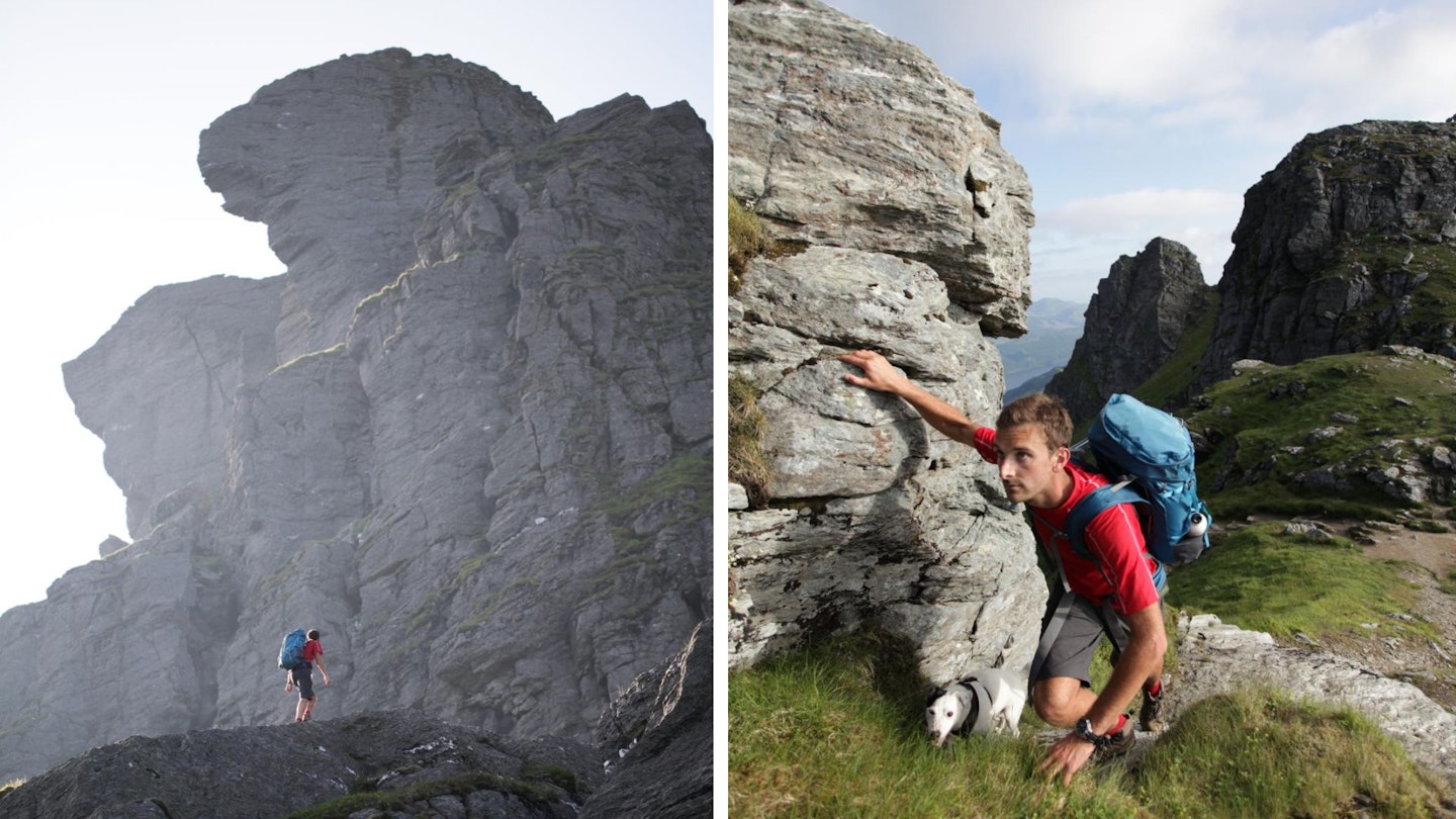
There are short sections of very mild Grade 1 scrambling on The Cobbler, but if you want to reach the mountain's true summit you need to tackle a very exposed and nerve-jangling Grade 2 scramble – known as 'Threading the Needle'. Trust us, we've been there and done it (that's our editor Oli nervously taking it on a few years ago), and it will set your pulse racing.
How long does it take to walk up The Cobbler and Beinn Narnain?
This is a fairly straightforward walk in terms of navigation, although the paths are unmarked and can be a little unclear on Beinn Narnain. Our route covers 11.4km (7 miles) and we estimate experienced hikers should be able to complete the route described below in around 6 hours, but that depends on weather conditions, your own fitness, and the pace you like to walk.
We advise taking your time and enjoying the views across Loch Lomond, Loch Long and the Arrochar Alps because they're some of the best in the southern Highlands. Ben Lomond is clearly visible to the south-east, with layer after layer of mountains stretching out towards the west coast and the Scottish islands
Where does the walk start from?
This route starts opposite the south end of Succoth car park on the A83, where there is also a bus stop served by the Citylink 976 service which travels from Glasgow to Oban via Inveraray. If you want something to eat or drink after your walk, we recommend dog-friendly Ben Arthur’s Bothy, in Arrochar, which serves hearty pub food and pints.
What's the best map for climbing The Cobbler and Beinn Narnain?
This route is covered by OS Explorer 364 (1:25,000), plus OS Landranger 56 (1:50,000). You can order printed maps from the Ordnance Survey's map shop or download our digital route guide HERE.
The Cobbler and Beinn Narnain | Step-by-step route guide
-
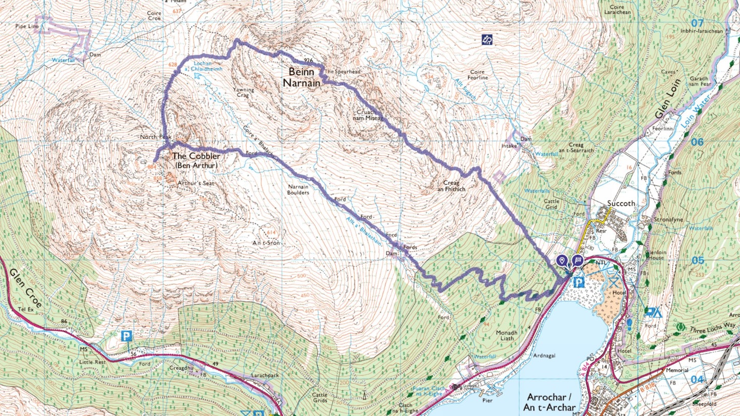
Opposite the south end of Succoth car park, take a path signposted for The Cobbler and Beinn Narnain leading southwest. After a very short distance, notice where the path crosses a small stream, and 25m later look out for the start of a much less distinct path on your right. Take this, heading northwest through the forest. It can be boggy underfoot.
-
After 250m, the path is intersected by a track; cross this and find where the path ascends steeply on the opposite side. Continue heading roughly northwest, ignore a left turn after 225m, and 500m further you’ll reach a T-junction. Turn right and continue uphill.
-
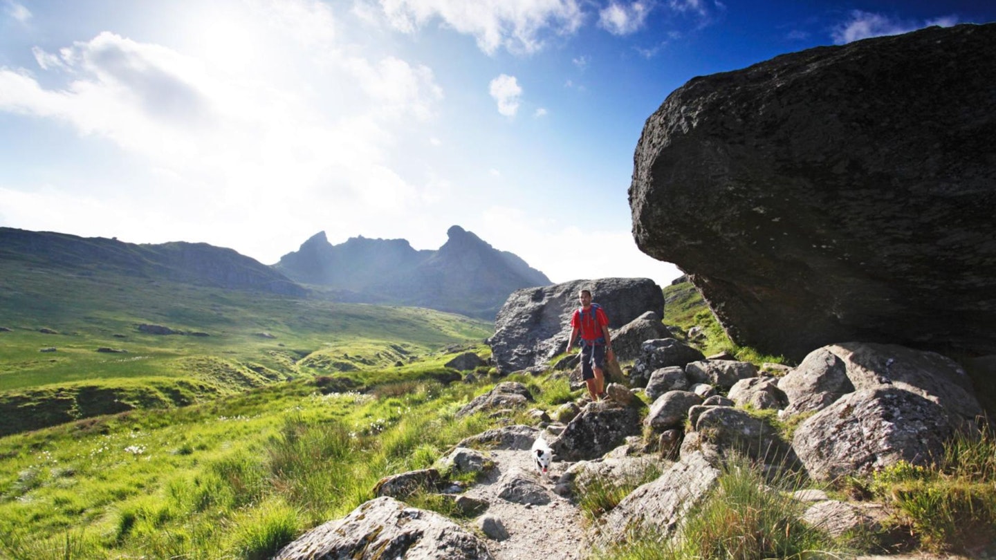
Leaving the forest, the path winds around rocks as you climb over Creag an Fhithich, with views over Loch Long and the Luss Hills, and on to Cruach nam Miseag where The Cobbler suddenly appears to the west. Finally, Beinn Narnain’s summit comes into view.
-
From the highest point of Cruach nam Miseag, the Spearhead rock buttress and precipitous rocks around Beinn Narnain’s summit look intimidating, but follow the path as it descends before climbing, initially around to the left, weaving around sharp boulders. After passing below The Spearhead, the most obvious route is to scramble up the gully on its right-hand side, but easier ground can be found by continuing a little further before turning left. Upon reaching the summit plateau, turn left and walk to the trig point. Looking south, you might catch a glimpse of Ailsa Craig on a clear day, while Ben Lomond breaks above the skyline to the east.
-
From the trig point, head towards the northwestern shoulder of Beinn Narnain, where Beinn Ime dominates the view, passing a couple of cairns and finding a path that begins to descend. Walk over a short section of small boulders before continuing on a grassy path heading west-northwest.
-
Roughly 600m from the summit trig, the path splits. Go left, heading in a more southerly direction on stone steps, descending gently towards Lochan a’ Chlaidheimh. As you reach the lower ground between Beinn Narnain and The Cobbler, turn left at the first junction, walk along the path for 140m southwest, and then turn right towards The Cobbler.
-
Follow the obvious path up The Cobbler, passing a detour to its North Peak on your left, until you reach the mountain’s highest central peak. The view from the summit plateau is spectacular enough, but in dry conditions a confident scrambler with a good head for heights might want to attempt the vertigo-inducing ‘true’ summit, which is a few metres higher.
-
To do this (bumping this route up to ‘hard’ with Grade 2 scrambling), approach the summit pinnacle over the boulders, then pass through a triangular hole in its base (a move called ‘threading the needle’). On the other side you’ll find a 1-metre wide ledge, slanting outwards. If you want to continue, turn left and go along the ledge before scrambling up to the summit. Remember this is the only option to return.
-
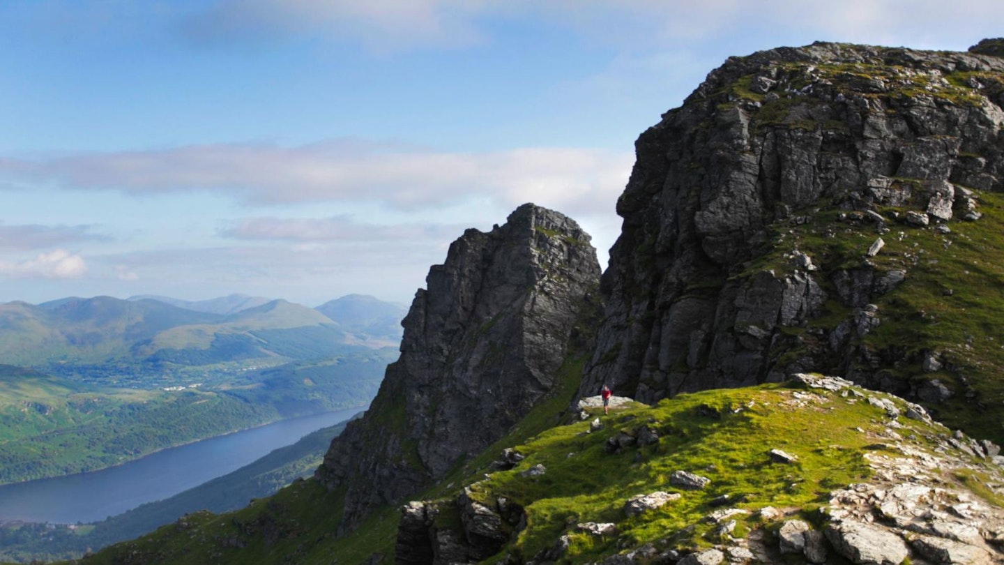
From the summit plateau, retrace your steps to the col between the central and north peaks, then find and follow a path on the right leading steeply downhill and below the imposing wall of the North Peak, before heading generally east for about 1km with some short sections of easy scrambling.
-
Reaching Coire a’ Bhalachain, turn right onto the main path which leads down to the forest. After 3km the path is intersected by a track, turn left onto this and walk for 50m before taking the path on your right, which leads back to the start.
What walking gear do I need for this route?
Here's a selection of the best walking and hiking gear selected by LFTO's testing team: Walking boots | Hiking shoes | Hiking daypack | Waterproof jacket | Walking trousers | Walking poles | Walking mid-layers | Base layers
Where's the best place to stay near The Cobbler?
If you want to base yourself near the start of the walk then Glenloin House Caravan and Camping Site is a convenient option. There are also plenty of B&Bs and a few hotels between Succoth, Arrochar, and Tarbet. Expedia and Booking.com are good places to look for good accommodation deals in the area.

This route originally appeared in the June 2024 issue of Trail magazine. CLICK HERE to become a Trail magazine subscriber and get 50% off a whole year of digital OS Maps