
Pen y Fan is the highest point in the Brecon Beacons National Park and a peak loved by everyone from experienced hikers and SAS troops, to families introducing children to the mountains. Almost every route to the summit would be worthy of a spot on our list of the best hikes in the UK, but this loop walk is easily our favourite.
Pen y Fan is the crowning glory of the south Wales mountains: a shapely, flat-topped, green-skinned giant, flanked by its outliers Cribyn and Corn Du. Pen y Fan reaches a height of 886m, which places it firmly in proper mountain territory, and the views surrounding it are some of the best you could ever wish to see.
All of that comes with a cost though, because Pen y Fan gets busy. Very busy, in fact. Most walkers ascend from the Storey Arms to the west, which at an altitude of over 400m offers direct and simple access to the summit. But we're not going to send you that way, because we have a far more spectacular route suggestion.
The loop described below climbs the long ridge of Bryn Teg up to Cribyn, before ascending to Pen y Fan itself. A detour to Corn Du is optional, but the route returns by descending directly off Pen y Fan and down the parallel ridge of Cefn Cwm Llwch. This is an unforgettable walk; save it for a fine day.
CLICK HERE to download our Pen y Fan digital route guide in OS Maps
How hard is climbing Pen y Fan?
If you're an experienced hiker, there's little to trouble you on this route up Pen y Fan. You'll find well-used and mostly clear footpaths on the hills, with farmland paths and quiet lanes below. That's why Pen y Fan is so popular with beginners and families, particularly in the longer and warmer days of summer.
Don't forget, though, the Brecon Beacons is a proper mountain region and Pen y Fan is its highest peak, so don't underestimate the walk. The higher you go, the more exposed and rocky the paths get and there is no shelter once you leave the road near Bryn Teg on the ascent. Good navigation skills will be needed in poor visibility.
How long does it take to walk up Pen y Fan?
This circular route covers 12.2km (7.5 miles) and around 870 metres of ascent. We estimate experienced hikers should be able to complete the route described below in around 4 or 5 hours, but that depends on weather conditions, your own fitness, and the pace you like to walk.
Where does the Pen y Fan walk start from?
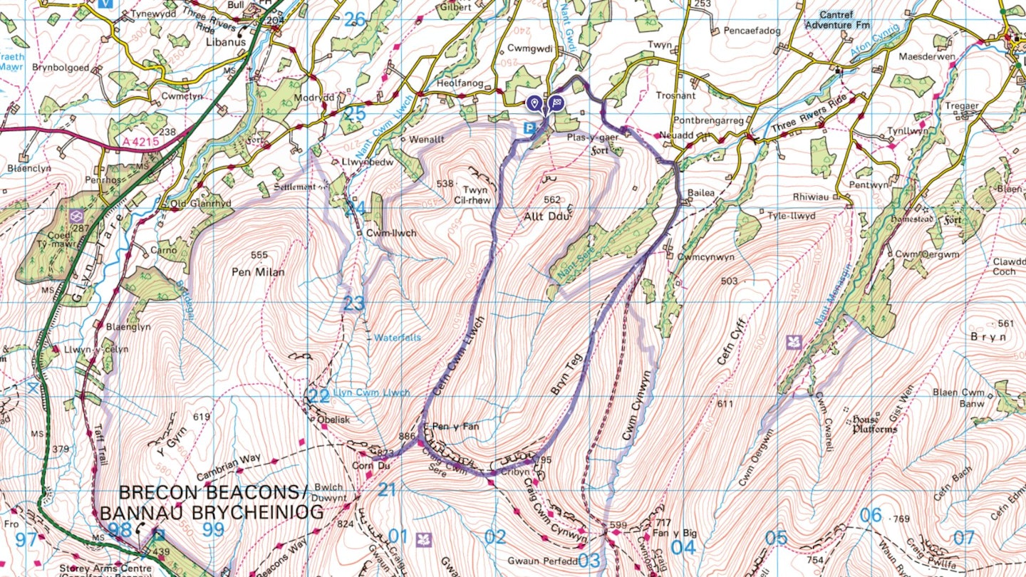
As mentioned above, the most popular starting point for climbing Pen y Fan is the Storey Arms, but our route begins in the quieter northern foothills of the mountain. Park in the National Trust Cwm Gwdi car park, 2 miles south of the town of Brecon at grid reference SO024248 (postcode LD3 8LE). Follow car park signs before reaching Heolfanog Farm. The closest train station is in Brecon – check thetrainline.com for times and prices.
What's the best map for Pen y Fan?
This route is covered by OS Explorer OL12 (1:25,000), plus OS Landranger 160 (1:50,000). You can order printed maps from the Ordnance Survey's map shop or download our digital route guide HERE.
Pen y Fan | Step-by-step route guide
Section 1
Exit the car park and turn left down the access road. Joining the lane at a bend, continue ahead, then turn immediately right over a bridge, and follow the lane. Where it bends sharp left, turn right on the lane heading towards the hillside, eventually arriving at Plas-y-gaer farm.
Section 2
Turn left through the gate, then right, following the fenceline around the farm complex. Cross the next meadow diagonally, climbing slightly and passing beneath the telegraph line, making for a fingerpost in the top right corner. Continue on the right edge of the next field, passing a line of trees. Cross the stile, then cross a sequence of meadows linked by stiles, to reach the access track to Pont y Caniedydd farm. Turn left on a track to reach a junction with a lane.
Section 3
Turn right and follow the lane, which descends to cross a bridge. The lane climbs sharply, passing Cwmcynwyn farm on the left. The lane becomes a stony track. Go through the gate to enter the National Trust Cwmcynwyn estate. At the fork, take the right-hand grassy track, climbing onto Bryn Teg ridge. Follow the ridge path for over a mile, eventually climbing sharply to reach the summit of Cribyn.
Section 4
Turn right and descend the steep path to Craig Cwm Sere ridge, which links across to Pen y Fan. Cross a small pool and a boggy area, then climb sharply on a clear path that ascends to the summit of Pen y Fan. The path gets rockier the higher you go, but is always more exciting than intimidating.
Section 5
There's an optional out-and-back detour to the west on a wide path to Corn Du, which adds just under half a mile to the route and then returns to the summit of Pen y Fan. From Pen y Fan's flat and rocky summit, take the path descending steeply in zig-zags off the northern ridge.
Follow the Cefn Cwm Llwch ridgeline to its furthest extremity. Drop down off the final ‘nose’, descending into the cwm between the two hills of Twyn Cil-rhew (left) and Allt Ddu (right).
Keep to the clearest, widest path, descending into a gorse-lined meadow. Cross a stile over the fenceline and continue across the next meadow. At the bottom, go through a gate to emerge on a stony track and continue to the car park.
What walking gear do I need for this route?
Here's a selection of the best walking gear selected by LFTO's testing team: Walking boots | Hiking shoes | Hiking daypack | Waterproof jacket | Walking trousers | Walking poles | Walking mid-layers | Base layers
Where's the best place to stay near Pen y Fan?
There are some excellent YHAs in the Brecon Beacons, which will base you very close to the mountains. We've used many of them on our recent trips to the National Park: CLICK HERE for more details. Expedia and Booking.com are good places to look for good accommodation deals around the nearby town of Brecon.
About the author
Oli Reed is the editor of LFTO and Trail magazine. He's walked, camped, and backpacked extensively in the Brecon Beacons over the past couple of decades and counts this route among his favourite in the British mountains. It may not be the most challenging mountain hike out there, but there are few more spectacular.
If you want more mountain routes like this, CLICK HERE to become a Trail magazine subscriber and get 50% off a whole year of digital OS Maps