
If you were to sit around the fireplace in a cosy Lakeland inn on a cold winter’s evening, look up from your pint of Loweswater Gold and ask the room “So, what do you reckon is the best horseshoe walk in the Lake District?”, a vibrant debate would be sure to ensue.
“You can’t beat the ruggedness of Mosedale Horseshoe.” “No way, Newland and Coledale are far better.” “You’re both wrong – it’s got to be the Deepdale Horseshoe.” The competition for top spot would be fiercely contested, but possibly this walk from Patterdale is the cream of the crop.
Ticking off six Wainwrights in a delightful day of skyline crest hiking, the Deepdale Horseshoe – a summit-bagging ridge walk forming a high-level loop of Deepdale Beck – is one of Lakeland’s best day walks. Some might say it's even one of the best hikes in the UK.
The highlights are fast-flowing, whether it’s the panoramas of Ullswater from Arnison Crag, the sweeping and shapely ridgeline of St Sunday Crag, the grandstand views north-west to Helvellyn and Striding Edge from Deepdale Hause, or the surprisingly gnarly cone-shaped peak of Cofa Pike. Or, in other words, it’s a slice of Patterdale perfection that’s tricky to beat.
How hard is the Deepdale Horseshoe?

Difficulty: Medium
Distance: 15.6km
Time: 6 hours
Total ascent: 1080m
Fitness: The mileage and ascent are reasonably challenging, and decent hill fitness is required for the steep ups and downs.
Terrain: Good fell paths throughout, with steepness in a few places.
Navigation: Paths are relatively clear, following obvious hill lines, but good navigation skills may be needed in poor visibility.
Where does the Deepdale Horseshoe start from?
Take Stagecoach’s 508 bus from Penrith and alight at Patterdale Hotel, grid ref NY395159.
What's the best map for the Deepdale Horseshoe?
The best maps for this route are: OS Explorer OL5, OS Landranger 90 or Harvey UltraMap XT40 Lake District East
Deepdale Horseshoe: Step-by-step route guide
-
From the bus stop, head south-east on the road past the White Lion Inn and old post office. Turn right between pub car park and row of cottages. Pass to the right of the public toilets, continue up the track and veer right past a building. Turn left and head west. Fork left over a stream and through a gate, and continue west across open fellside. Where a path meets a wall, next to the gate entering Glenamara Park, turn left and climb steeply south alongside wall towards Oxford Crag. Pass right of a huge rocky outcrop, and continue uphill with a wall on your right. Continue following a good path uphill. About 50m after path veers slightly away from wall, fork left and take narrow trod south to Arnison Crag's cairned summit.
-
Descend briefly south before looping sharp right and then sharp left on a trod leading to col with small tarn. Pick up a grassy path heading south-west to Trough Head. From NY388142, turn right and pick up trod heading north and north-west to meet an old drystone wall. Follow wall north-west uphill to reach the broad, grassy ridge. Turn left and ascend gently to Birks’ summit.
-
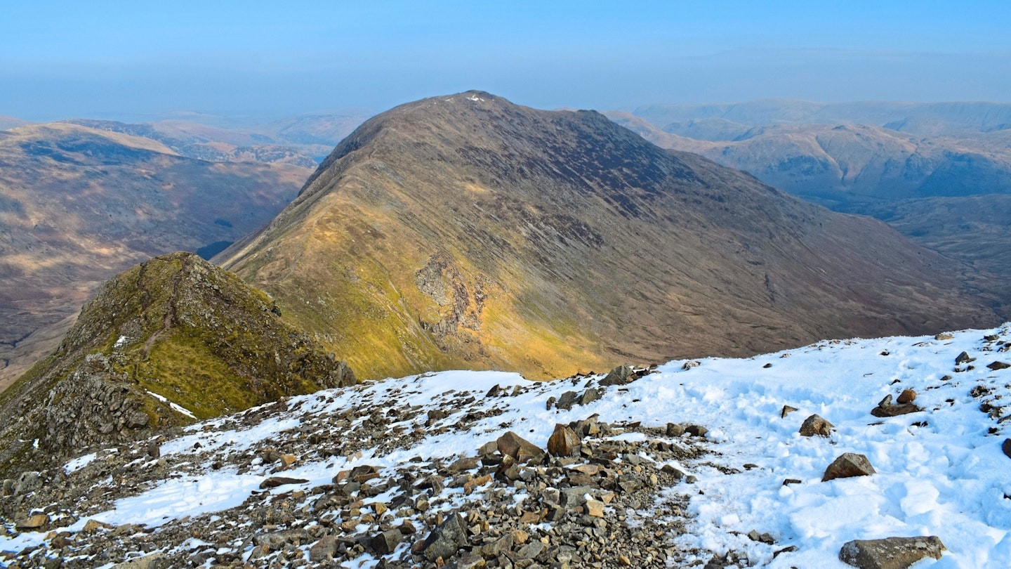
Descend south-west over undulating terrain to a col above Blind Cove and at the base of St Sunday Crag's north-eastern ridge. Ignore turn-offs to the left, which bypass higher ground, and instead ascend the ridge directly guided by a good path. It’s rocky and steep in places, but never becomes full-blown scrambling. Top out of ridge onto gentler slopes. Fork left and ascend south to St Sunday Crag’s summit.
-
Descend the long sweeping ridge south-west down to Deepdale Hause col. Ahead cone-shaped Cofa Pike looks unclimbable, but a zigzagging trod guides you over rocky ground to its cairned top. Descend briefly south-west before climbing a dramatic blocky outcrop, or bypassing it safely on a trod to its right. Reach a mini col and climb directly ahead over craggy ground to emerge at a broad plateau. Walk south-east to Fairfield’s summit cairn.
-
Descend a wide track south-east, east and south-east again to Link Hause col. Climb south-east and veer right off main path briefly to reach the summit of Hart Crag. Descend back to the path and at junction, fork left. Descend north-east to a large cairn marking the start of ridge descent. It’s possible to descend ridge directly, but it’s steep and craggy, so instead veer right and take bypass path to south of the ridge. Descend east to base of rocky ridge. Head north-east over much gentler terrain to Blake Brow. Descend gently to col and ascend a good path north-east to Hartsop above How.
-
Descend ridge north-east to Hoggill Brow. Reach a wall and follow it north-east, ascending briefly to Gale Crag, before continuing the long descent north-east. Veer northwards, sticking to left-hand side of wall. Cross the ladder stile at T-junction of walls, and veer left around crags. Descend north on clear path through Deepdale Park. Go through a gate, descend woodland and emerge beyond another gate into open field. Cross field northwards and go through another gate next to a bus stop (you can catch a ride here in summer). Emerge onto the A592. Turn left and go through Bridgend hamlet. Head north along road, sticking safely to verges, and arrive back into Patterdale.
View the Deepdale Horseshoe route in OS Maps.
What walking gear do I need for the Deepdale Horseshoe?
We'd recommend the obvious basics of walking boots or hiking shoes, a good hiking daypack, a reliable waterproof jacket, and a pair of quick-drying walking trousers with some packable waterproof overtrousers in your bag.
You should also carry insulating layers because it can get cold, especially when you're up on the exposed tops of the Lake District fells.
Where can I eat and drink?
The Patterdale Hotel’s ‘Place Fell Inn’ bar serves pub grub and drinks. Numerous cafés including Fellbites Café are available in nearby Glenridding.
Where's the best place to stay?
Hotels, B&Bs and campsites are plentiful in Patterdale, including Side Farm Campsite and Patterdale Hotel.
About the author
James Forrest writes regular features and route guides for Trail and LFTO, and has been one of our main gear testers for the last few years. James is based on the edge of the Lake District so when he isn’t off on his latest crazy adventure or challenge, he’s walking in his local fells.
This route originally appeared in the December 2024 issue of Trail magazine. Become a Trail magazine subscriber and get 50% off a whole year of digital OS Maps