
They are regularly labelled the ‘Boring Berwyns’, but is that fair? The Berwyns are an often-ignored mountain range of high moorland east of Bala, lying just outside Snowdonia National Park. Cadair Berwyn is the highest point in the range.
Most of the rounded tops are covered in thick, energy-sapping heather – enough to turn off all but the most dedicated of peak-baggers like me. I’ve climbed 23 peaks in the Berwyns and much of it was an exhausting battle against the deep heather, as if I was vaulting over thousands of purple-flowered hurdles.
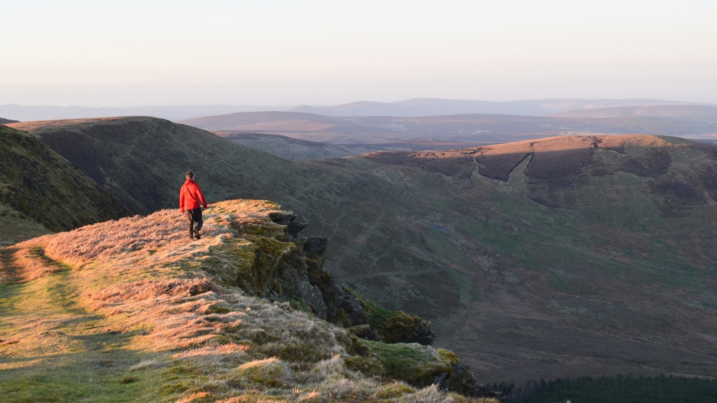
But, in truth, the ‘boring’ label applies more to the northern and western sections of the range. In the middle the heather relents, good paths abide, and an enjoyable high-level horseshoe walk is possible from Cwm Maen Gwynedd, bagging the trio of Cadair Bronwen, Cadair Berwyn and Moel Sych – easily the best day walk in the Berwyns.
And, for added interest, when you’re standing atop Cadair Berwyn you can ponder the ‘Roswelsh Incident’: a bizarre occurrence in 1974, when loud noises and bright lights were seen over the 830m mountain. Was it a UFO crash, covered up by the government? Or an earthquake combined with a meteor shower, as per official statements? Whichever way you look at it, not such a boring place after all!
For more inspiration, check out our selection of the best hikes in the UK.
How hard is the Cadair Berwyn ridge walk?
Difficulty: Medium
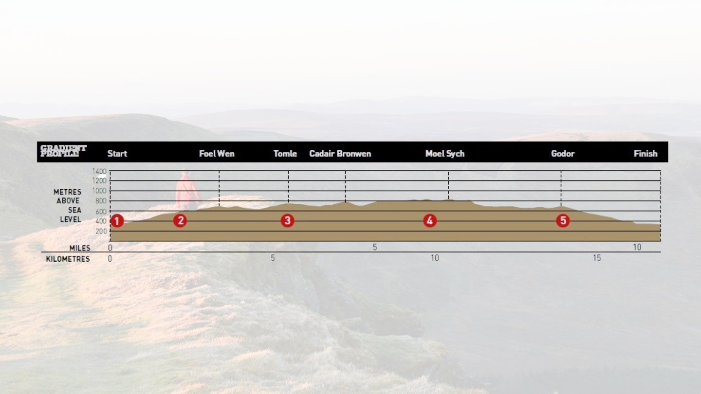
Distance: 17km (10.5 miles)
Time: 5.5 hours
Total ascent: 849m
Fitness: Good hill fitness is required for this moderate, high-level walk.
Terrain: Generally good mountain paths throughout, with a few peat groughs to negotiate on the wide, boggy ridge. Steep descent to Moel yr Ewig, and rough and pathless over Godor.
Navigation: Good navigational skills are required, as there are points where paths are unclear or non-existent.
Where does the Cadair Berwyn ridge walk start from?
Parking is very limited at the start point in Cwm Maen Gwynedd, but there's space for a few cars by the bridge over the stream. The nearest town is Llangollen.
What's the best map for Cadair Berwyn?
The best map for this route is the OS Explorer 255.
Cadair Berwyn | Step-by-step route guide
-
Head north-west up the road to Tyn-y-ffridd. At the red telephone box, turn right and head uphill to pass the farm buildings at Maes. Continue north and, where the lane swings right, go through a gate and climb diagonally through a field. Pass through the gate into the next field and veer right along a line of trees to follow the edge of the field. Go through yet another gate and turn sharply west to skirt the southern slopes of Mynydd Tarw. The path is initially unclear underfoot, but as you veer north-west a 4x4 track emerges with a clear grassy platform. When the 4x4 track swings north for the ridge, leave it to pick up a fainter trod traversing steep slopes to join the fence at the col.
-
Turn left and follow the fence north-west to the 687m bump of Foel Wen’s south top. Sticking to the thin trod to the left of the fence, descend easily to the col and climb again to the main 691m top of Foel Wen. Drop down north-west to the next col and, using the fence as a continual handrail, head west towards Tomle. Follow the fence sharply left and then, where it turns 90° right, a small pile of white quartz rocks mark the 742m summit.
-
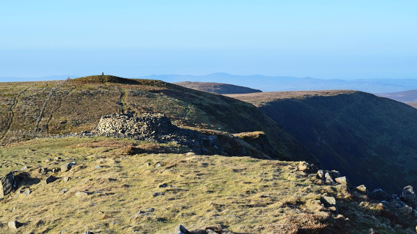
Head north-west along the fence, negotiating peat hags, and follow the fence left briefly. Ignore the steep grassy path to the main ridge ahead and instead turn right through a gate on a good path that traverses to Bwlch Maen Gwynedd. Go through another gate and turn right, heading north. The grassy trod includes intermittent sections on raised wooden planks. Cross a stile and climb to the large cairn of Cadair Bronwen. Re-trace your steps to the col and climb south following the fence. Pass the 827m trig point, continue to a large wind shelter and finally reach Cadair Berwyn’s 830m summit.
-
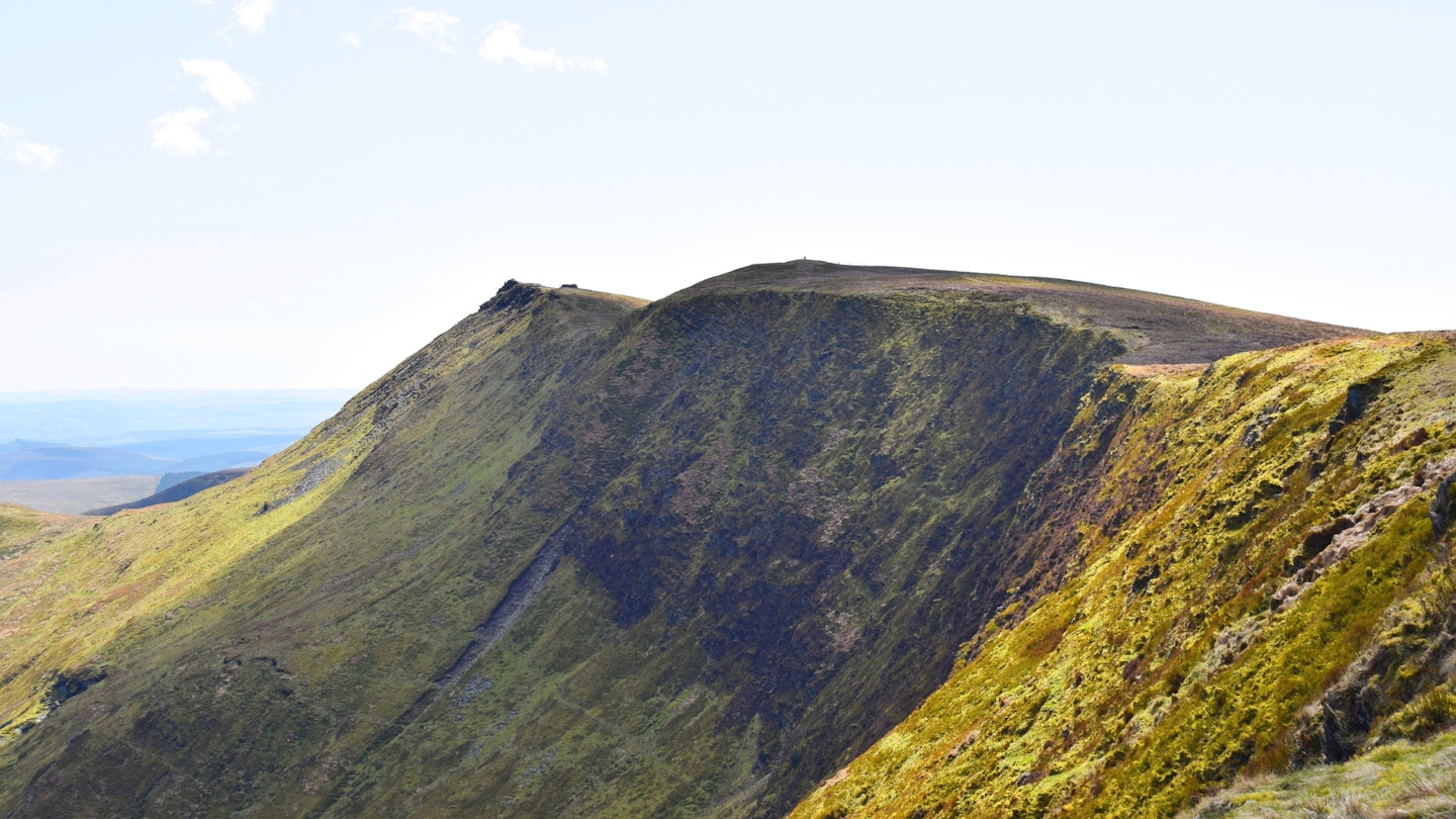
Descend briefly to cross a stile and follow the fence south-west to climb to the 827m summit of Moel Sych. Re-trace your steps to the lowest section of the col and turn right into a gully. This clear path descends steeply south-east, re-joining the fence at a corner, and veers south-east passing to the right of the 724m spot height. Continue on the trod to the col before ascending briefly to the 695m top of Moel yr Ewig. Continue briefly and, where the fence turns right, cross a stile and go straight ahead to cut off a corner. Negotiate a deep peat grough and re-join the fence, continuing south-east over rough ground to the 675m north top of Godor. Descend to the col and stick to the trod, which veers away from the fence heading for the small cairn on the 679m summit of Godor.
-
Follow the fences down the eastern shoulder of Godor, passing to the right of a thin plantation of evergreen trees and going through a series of gates to join the lane to the north-east of Bryngwyn. Turn left and head north-east. Where the lane loops sharply right, continue straight ahead over a stile and descend to the right around the edge of a forest towards Waen. Cross a stile, turn right, cross another stile and turn left through a field. Take the footbridge over the stream and climb north-east back to the phone box at Tyn-y-ffridd. Turn right on the road and veer right at the fork to return to the bridge.
Find the Cadair Berwyn horseshoe trail route on OS Maps.
What walking gear do I need for this route?
We'd recommend the obvious basics of walking boots or hiking shoes, a good hiking daypack, a reliable waterproof jacket and a pair of quick-drying walking trousers with some packable waterproof overtrousers in your bag.
You should also carry insulating layers because it can get cold, especially on a high-level horseshoe walk like this one.
About the author
James Forrest writes regular features and route guides for Trail and LFTO, and has been one of our main gear testers for the last few years. James is based on the edge of the Lake District so when he isn’t off on his latest crazy adventure or challenge, he’s walking in his local fells.
This route originally appeared in the November 2018 issue of Trail magazine. CLICK HERE to become a Trail magazine subscriber and get 50% off a whole year of digital OS Maps