
This superb walk ascends Waun Fach, the highest mountain in the Black Mountains, and has stunning panoramic views over three counties. It starts and finishes at Dinas Castle Inn, where food, drink and accommodation is offered so you can stay and walk from the door if you choose to.
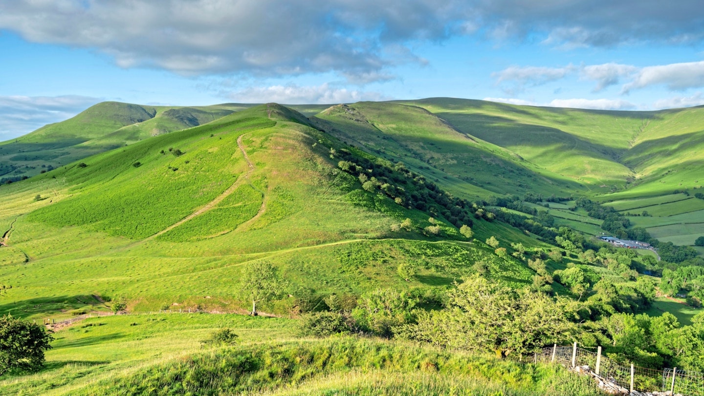
The route descends Y Grib, a narrow spur of land known as the Dragon’s Back (not to be confused with the Peak District's Dragon's Back), to Castell Dinas, an impressive Iron Age hill-fort with a commanding view of the Rhiangoll Valley.
For more inspiration, check out our selection of the best hikes in the UK.
How hard is the Castell Dinas and Waun Fach route?
Difficulty: Medium
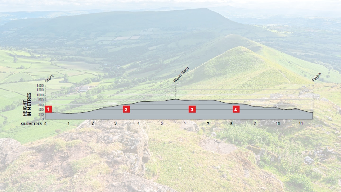
Distance: 11.5km
Time: 4.5 hours
Total ascent: 663m
Fitness: A reasonable level of walking fitness is required.
Terrain: Steep ascent to Waun Fach and some boggy areas on the mountain tops.
Navigation: Straightforward on well-marked paths in good weather, but upland part is featureless and may be tricky in poor visibility.
Where does the Castell Dinas and Waun Fach walk start from?
For public transport, the TrawsCymru bus service (T14) runs from Hereford to Brecon via Hay-on-Wye, while the X12 takes you to Pengenfford at the start of the walk. There is easy access to the M4.
What's the best map for Castell Dinas and Waun Fach?
-
OS Explorer OL13 (1:25k)
-
OS Landranger 160 (1:50k)
Castell Dinas and Waun Fach | Step-by-step route guide
-
At the northern end of the pub car park, descend a set of wooden steps, marked with a waymark arrow to Castell Dinas, into the lane below and turn right down the track. After about 50m there is a stile on the left. Ignore this – it will be your descent route at the end of the walk. Walk behind and below the Castle Inn and after 200m the track divides. Keep to the left past a farm and cross a ford to meet a road on a bend.
-
Turn left and follow the road, passing Cwmfforest Farm on the left, continuing to where another road joins from the left. Shortly afterwards, turn left onto a bridleway to the hill fence.
-
Cross Rhiw Trumau to the cairn at the col.
-
Turn north and follow the ridge along Pen Trumau to Waun Fach.
-
Take the obvious path that descends a little to the north and then skirts around the eastern ridge of the Rhiangoll Valley. Climb slightly to Pen y Manllwyn and about 500m from the rather unclear summit drop down the hillside in a westerly direction to Y Grib. Keep to the summit of the ridge, avoiding the paths to the right and left which descend below the ridge itself. There are three sections to the ridge with short descents and climbs to the separate summits, and you will pass a substantial cairn on the way down past a few rocky outcrops. On the last summit before the castle hill is a round stone shelter.
-
Drop down quite steeply from this to a gate ahead. Cross the stile and climb up ahead to the remains of Castell Dinas. A more obvious path to the right should be avoided as it bypasses the castle remains. Drop to the right to a stile. Descend the field, keeping the fence to your right, to reach another stile. Keep descending to the stream, which is easily crossed, to a stile leading into the lane where the walk began. Turn right and walk 50m to the steps and back to the start.
Find the Castell Dinas and Waun Fach route on OS Maps.
What walking gear do I need for this route?

We'd recommend the obvious basics of walking boots or hiking shoes, a good hiking daypack, a reliable waterproof jacket and a pair of quick-drying walking trousers with some packable waterproof overtrousers in your bag. You should also carry insulating layers – it can get cold on the exposed mountain tops.
Where can I eat and drink?
The route starts and finishes at Dinas Castle Inn, or there are a few more options at Talgarth a few miles away.
Where's the best place to stay?
B&B, bunkhouse and camping at Dinas Castle Inn. More options at Talgarth or Hay-on-Wye.
This route originally appeared in the February 2025 issue of Trail magazine. CLICK HERE to become a Trail magazine subscriber and get 50% off a whole year of digital OS Maps
About the author
Andy Davies is an outdoor photographer and author of numerous Welsh walking guides, including Coastline Wales, Walking on Gower and Walking in the Brecon Beacons. He moved to western Wales in 1999 to be immersed in the environment which inspires him, and is now a regular contributor to both Trail magazine and Live for the Outdoors.