
The Scottish Highlands isn't short of great mountains and memorable hiking routes, but some still shine brighter than others. Beinn Alligin in Torridon is one of them – home to two Munros, a vertigo-inducing chasm, a masterpiece of a scrambling ridge, and possibly our favourite single-day walk in the British mountains.
Torridon is one of Britain's most impressive mountain regions, made famous by the iconic triptych of peaks Beinn Alligin, Liathich, and Beinn Eighe. All three are epic for exploring in their own way, featuring multiple summits, spurs and edges, as Claire Maxted experiences below in her thrilling tour of Scotland's 'Jewelled Hill'.
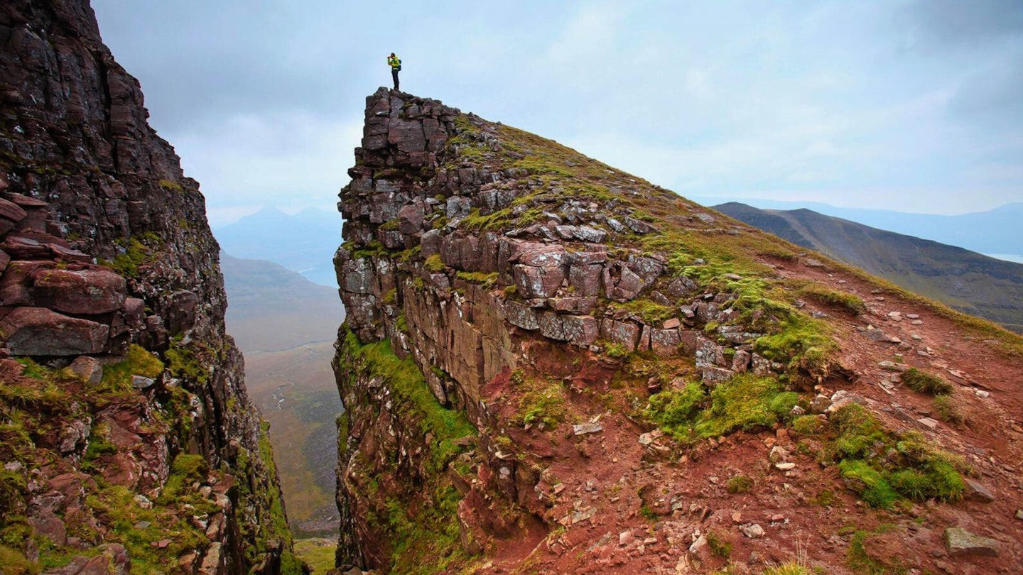
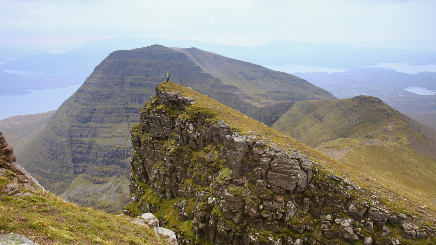
Beware the Eag Dhubh nah-Eigheachd! The name means ‘Black Gash of the Wailing’ in Scottish Gaelic and it’s a huge rockslide slash in the side of this mountain range just before Sgurr Mor. Legend has it local shepherds would hear cries from this terrifying drop, yet if they went to investigate they would fall to their deaths and become part of the eerie soundtrack themselves. I didn’t hear any wailing apart from the wind when I walked this and it remains one of my favourite walks of all time.
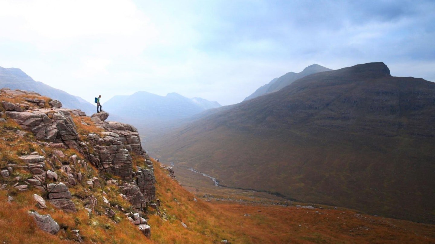
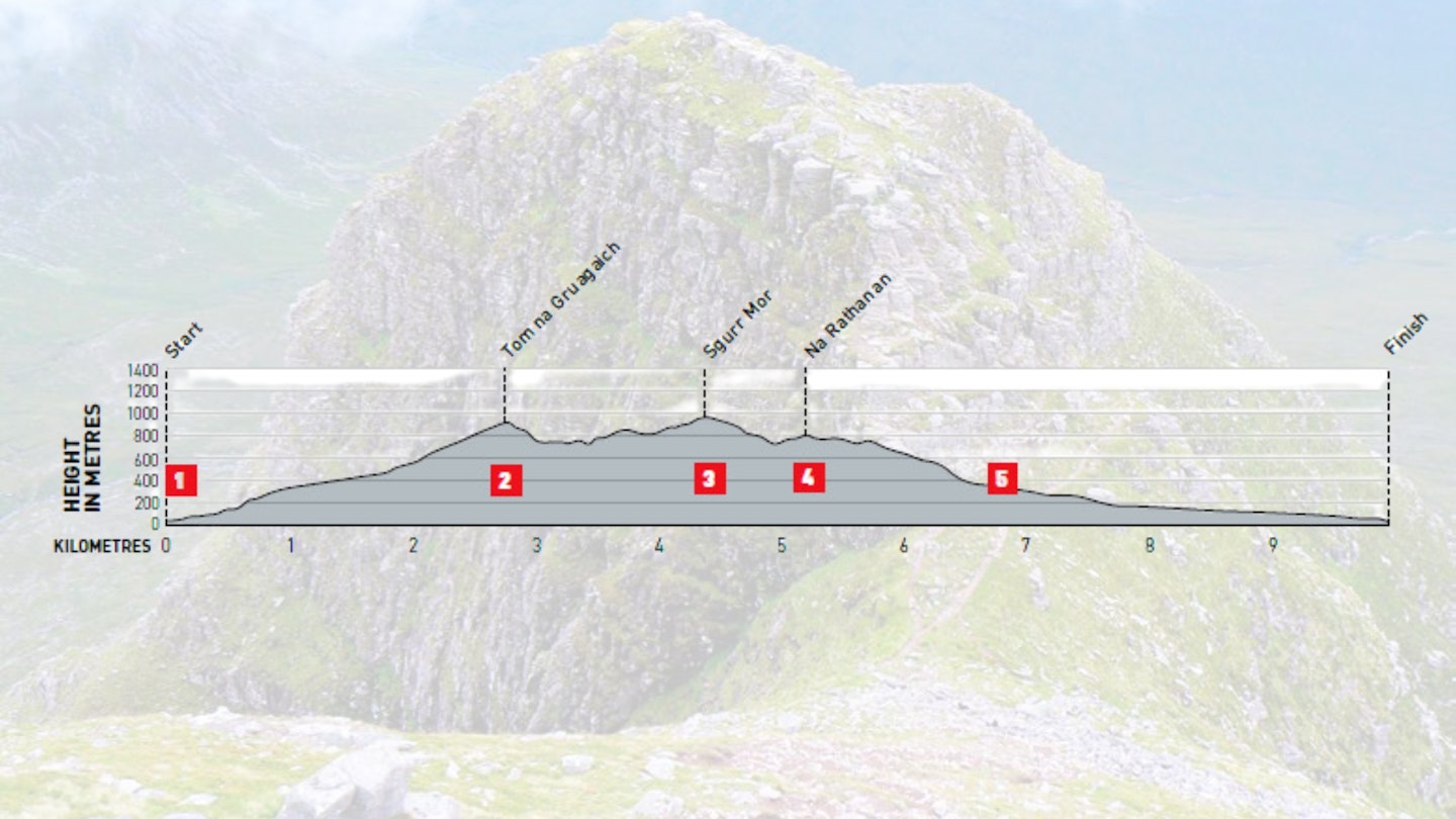
The name Beinn Alligin means Jewelled Hill, and it's a gem of a circuit. It’s straightforward for experienced scramblers without snow and ice, but winter skills are needed for colder conditions. After just one big climb up to the first Munro, Tom na Gruagaich (922m), you enter into a high, mountainous world.
Here at the trig point, pause to take in the fantastic view of the swooping, triangular-peaked and narrow ridge ahead to Sgurr Mhor and Na Rathanan. It’s also interesting to know that Tom na Gruagaich received Munro status relatively recently, being promoted from a Top in 1997.
How hard is climbing Beinn Alligin?
TERRAIN: Well-trodden paths rocky most of the way, especially on the ridges and summits.
FITNESS: High fitness and good co-ordination and balance needed for very uneven, high and rocky terrain.
NAVIGATION: Straightforward in good weather but good care is needed if tackling in poor visibility, so as to navigate cliff-edge paths and narrow ridges safely.
Where is the start of the walk?
The nearest train station is Strathcarron, then bus 702 to Torridon General Store, then walk last two miles west along road. If you're driving, the start point is the car park at grid ref NG868577.
What's the best map for Beinn Alligin?
-
CLICK HERE to view and download our digital route guide in OS Maps
-
OS Explorer 433 (1:25k)
-
OS Landranger 24 (1:50k)
-
Harvey Superwalker XT25 Torridon (1:25k)
Beinn Alligin Traverse | Step-by-step route guide

-
From the car park on the west side of the Abhainn Coire Mhic Nobuil (river), walk back towards the road bridge (you can see some great waterfalls here). Ignore the large path on the east side of the river, and instead take the smaller path on the west side, which soon leads to a stile on to the southeastern flanks of first Munro Tom na Gruagaich. There are rocky outcrops all the way up that you can scramble over, or just follow the path up into Coire nan Laogh, keeping the Alltan Glas (river) on your right almost all the way to the top, where you cross one of its tributaries and climb steeply to the 922m trig point.
-
Leave the summit via the path running north-west, with steep cliffs to your right. The path runs clearly down the northern ridge, rocky and steep, and very straightforward to follow in good conditions. Keep the steep cliffs to your right as you follow the ridge round to the right, curving north-east to the spectacular Eag Dhubh gully. Skirt left around it and keep following the steep cliff edge to your right to climb south-east, then north up to the small, triangular top of Sgurr Mor (986m).
-
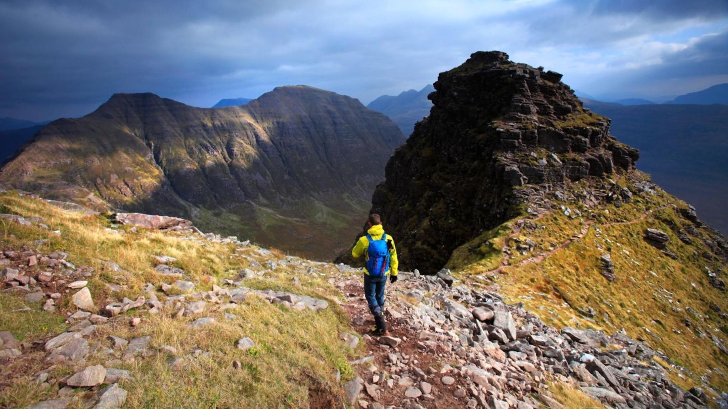
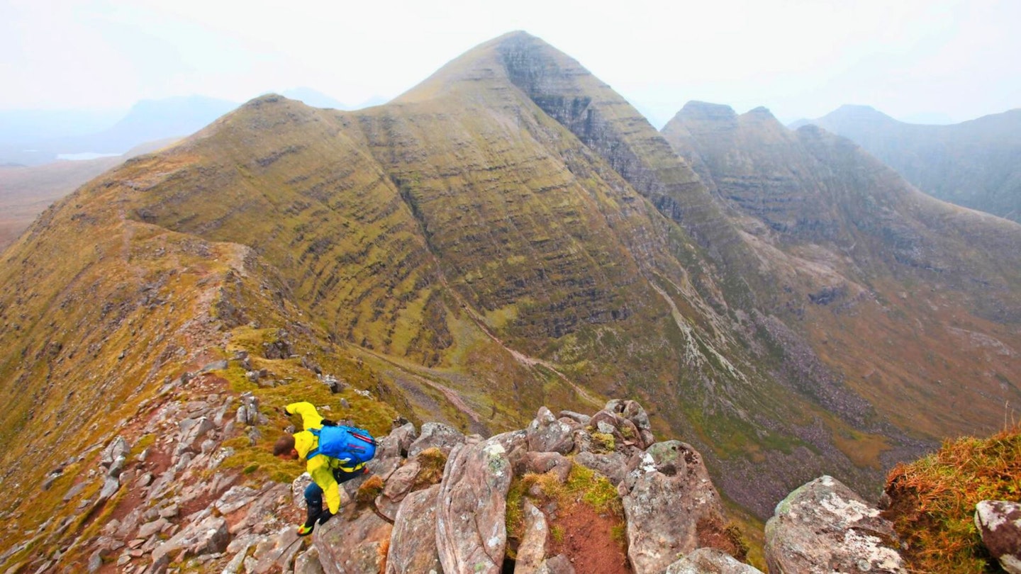
On a clear day there’s a fantastic view of Beinn Dearg from here, behind the three Horns of Alligin (Na Rathanan) – the next part of the route. Descend Sgurr Mor via the north-western path, which gradually curves eastwards and negotiates the Horns. Don’t be tempted by the small path traversing the Horns to the right – the slopes are so steep, grassy and slippery that it’s much safer to scramble over the rocks. The scrambling is straightforward on the first two, then on the steepest section of the third, traverse right and up a small chimney section to get back to the ridge. Less confident scramblers might require a rope here.
-
There is a nice clear path descending south-east from the third Horn, which guides you steeply down and around many rocky outcrops and miniature cliffs. The route can also be walked anticlockwise, and this section in ascent makes for fantastic scrambling next to the path. The slope eases, then there’s a final steep section through crags as the path descends into Bealach a’Chomhla and meets with the path coming from that valley, marked by a small cairn.
-
Continue downhill across muddy moorland to cross the Allt a’Bhealaich and descend with the river on your right (west), admiring the small but impressive waterfalls as you go. This path soon meets a footbridge over the Abhainn Coire Mhic Nobuil and descends gradually on a large, well-used path, through the pine woods to the road bridge and car park with the river on your right (east).
What walking gear do I need for this route?
Here's a selection of the best walking gear selected by LFTO's testing team: Walking boots | Hiking daypack | Waterproof jacket | Walking trousers | Walking poles | Walking mid-layers | Base layers
Where can I eat and drink in Torridon?
The Torridon Stores & Café (General Store, where the bus stop is) has nice cakes and toasted sarnies. There are more restaurants near The Torridon hotel on the A896.
Where's the best place to stay near Beinn Alligin?
The Torridon hotel on the A896 if you’re feeling flush! Or Torridon SYHA, Stalkers Cottage, Fasaig Cottage or Tigh Loran B&B in Torridon village itself.
About the author
Claire Maxted is a former writer for Trail magazine and the former editor of Trail Running magazine. She's written countless route guides and gear reviews for LFTO and is the founder of www.wildgingerrunning.co.uk
This route originally appeared in the May 2021 issue of Trail magazine. CLICK HERE to become a Trail magazine subscriber and get 50% off a whole year of digital OS Maps