
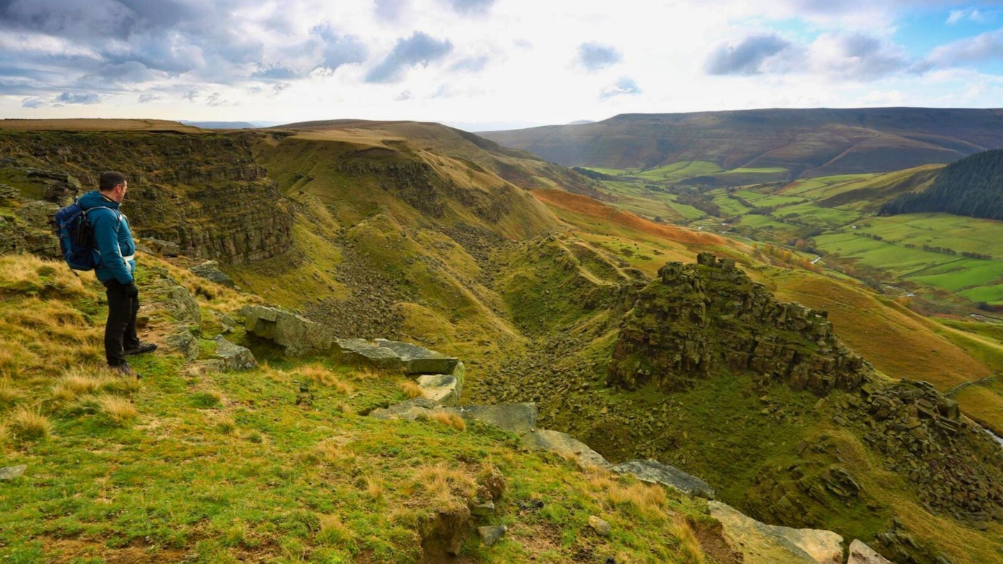
Hidden up an otherwise unremarkable valley in the Bleaklow massif is Alport Castles, one of the finest scrambling arenas in the Peak District.
This famous old National Park, littered with giant gritstone boulders and laced with escarpments that drop into fissured edges, is renowned for the quality of its climbing.
Several world-class athletes live within easy reach of it for exactly this reason. And though scrambling routes can be found here too, they aren't as plentiful, which makes Alport Castles particularly special.
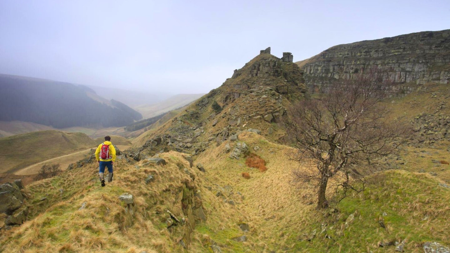
Carved between two spurs of grassy moorland is this 300m long landslip – an amphitheatre of crumbling gritstone with an arresting tower at its centre and peregrine falcons nesting in the crags. The edge itself is damp and unstable, suitable only for ice climbing after a long, hard freeze, but the tower has opportunities ranging from Grade 1 to Grade 3.
It is a perfect playground. You can approach it on a there-and-back walk from the A57, but this route takes advantage of the Peak’s bus routes to tie in a stroll along the forested edge of the reservoirs and a high stride back above the valleys. There’s even a pub just a jaunt up the road.
How hard is the walk?
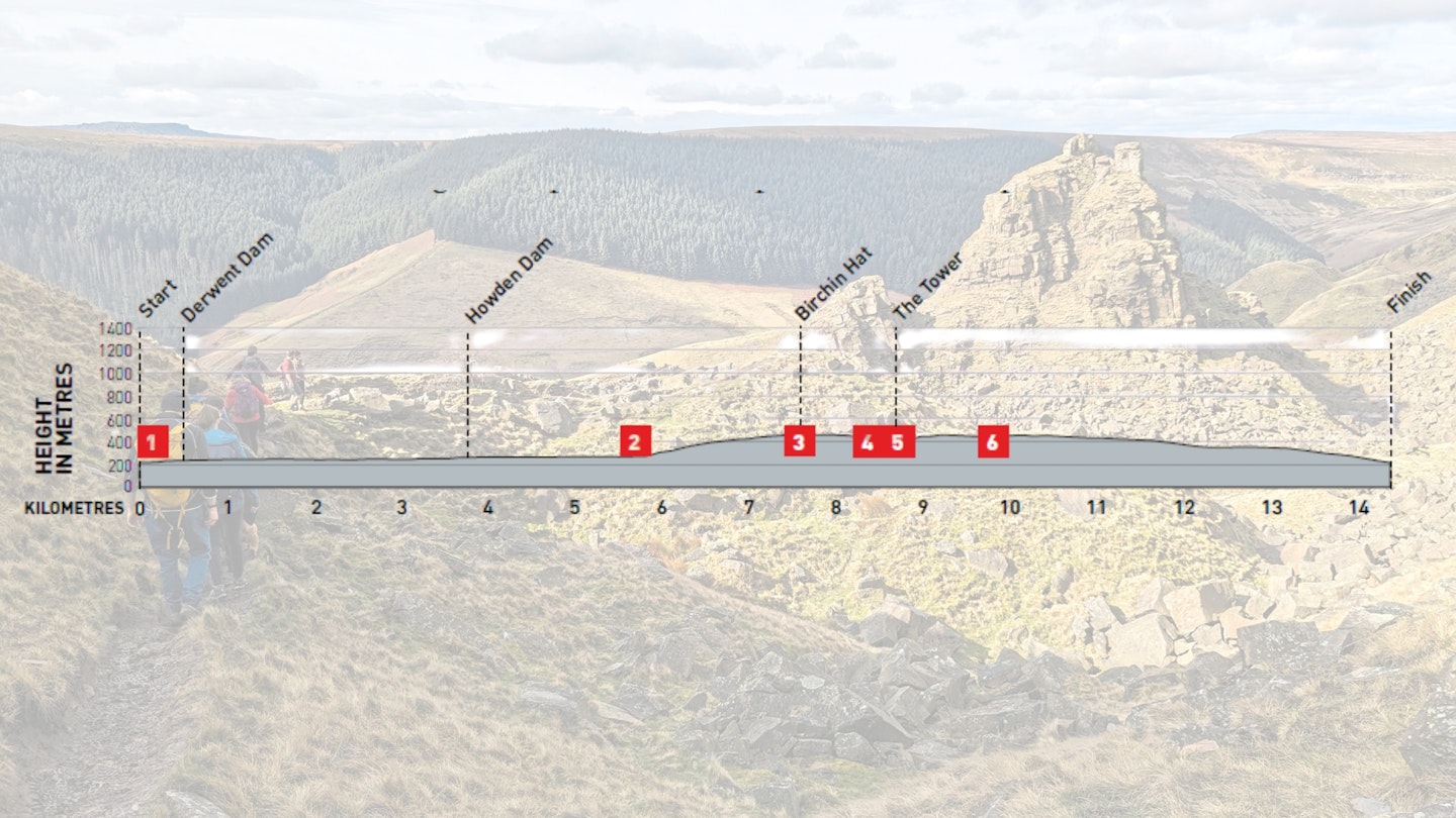
DIFFICULTY: Medium | DISTANCE: 15km
TIME: 5 Hours | TOTAL ASCENT: 428m
FITNESS: The walk in and out is moderate, although taking on the harder scrambles will require balance and agility. Overall, the route described below is fairly easy with an optional exposed Grade 1 scramble (described) and other Grade 2/3 options.
TERRAIN: Closed road, hill tracks, rocky landslip, paved hill path, grass path.
NAVIGATION: Generally obvious, but the return route is laced with paths, so attention is needed here.
Where is the start of the walk?
Hulleys of Baslow bus 257 runs between Sheffield and Bakewell. Parking at Fairholmes, Heatherdene and roadside, though it can be busy.
How do I walk to Alport Castles?
Best printed maps:
Alport Castles | Step-by-step route guide
-
Leave Fairholmes and join the singletrack road towards Derwent Reservoir, passing the giant Derwent Dam. This road is often closed to vehicles and with plantation on the left and the rippling reservoir on your right, it’s almost as lovely as a road walk gets.
-
After 3.75km, approach Howden Dam and continue to follow the road along its western shore. The road dog-legs left to come alongside a branch of the reservoir fed by the River Westend. Where the road turns right to cross a bridge over the river, keep ahead to join a track.
-
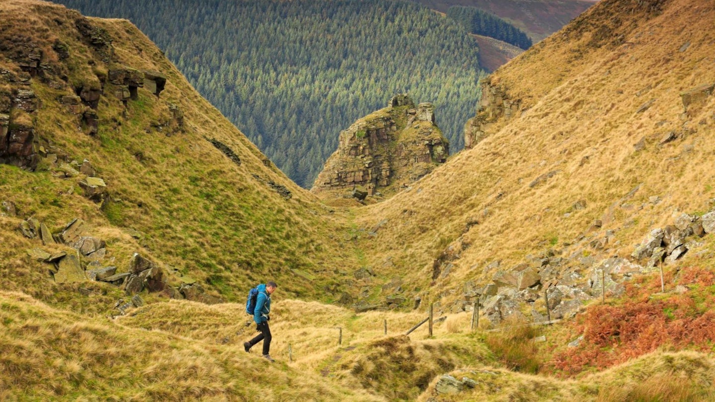
The bridge with the river pouring forth underneath is a lovely spot for a break and with a climb imminent a good point to shed a layer. Follow the track into the trees until, after 180m, you meet a forestry track branching left uphill. Take this and start on a steady uphill through trees.
-
After about 500m emerge onto the open hill and continue following the track up a spur. The gradient will gradually start to shallow out and the track will come near a gully. Continue on the same trajectory following the track until you reach the edge of the escarpment.
-
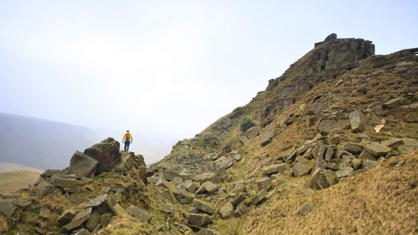
Directly below is the Alport Castles landslip, a brilliant rocky playground full of potential. Of all the knobbly castellations, the most obvious and tempting is The Tower. Turn left along the edge to find a worn path dipping down behind Little Moor beside a crumbling wall and take this into the boulder field to the foot of this obvious promontory.
-
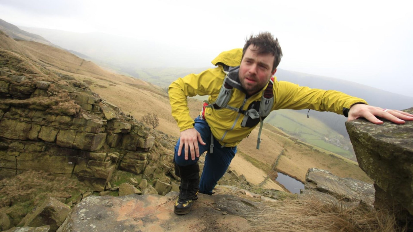
There are a number of routes up The Tower, with grades ranging from 1-3. For a good Grade 1, approach from the south-east and clamber up a small ridge with a knobbly fin of rock. Move along a faint grassy path to the shale and scrubby rock at the base of The Tower. Climb up to an obvious steep section where the situation becomes more exposed.
-
Traverse left on an obvious ledge around the corner to find an easier route up, sticking to the rock as much as possible. Emerge on top and scamper over to the protruding knobble for an excellent photo opportunity – you’ll need a pal positioned on Little Moor for the best image.
-
Descend to the west on slabs and easier ground. Near the base, veer rightwards to come between The Tower and Birchin Hat and rejoin the path you took down from the moor above. Ascend to rejoin it and follow a worn grassy path east of south, following the escarpment edge. The path is badly eroded where it comes alongside a drystone wall, but after crossing another crumbling wall it is replaced by a good, millstone path.
-
Follow this path along the edge of the escarpment. After 1.3km the millstones run out and you’re back on eroded ground but continue along the edge to a gate in the corner of the moor where a wall meets a plantation. Go through the gate to follow a path between the plantation edge and a drystone wall. Cross a stile over a wall and continue on the same trajectory to come close to the trees. Here, meet a forked gravel track.
-
Stay high on the left fork by the trees. At grid ref SK170885, a drystone wall meets an arrangement of gates with a track veering left (east) down through pines marked by a stubby fingerpost. Take this track downhill. Soon, it kinks right to traverse down to the road, a small car park and a bus stop.
What walking gear do I need for this route?
Although this isn't the longest or hardest route you'll ever do, this is still a proper hillwalk covering a decent distance, so shouldn't be taken too lightly.
We'd recommend the obvious basics of walking boots or hiking shoes, a good hiking daypack, a reliable waterproof jacket (it rains a lot in the Peak District!), and a pair of quick-drying walking trousers with some packable waterproof overtrousers in your bag.
Where can I eat and drink?
Tea, spuds and sarnies at Upper Derwent kiosk. Good pub grub at Anglers Rest, Bamford on the bus route. Upmarket options at the Ladybower Inn.
Where's the best place to stay?
Pubs: The Ladybower Inn, The Yorkshire Bridge Inn.
Campsites: Heatherhill Farm, Bamford (no showers); Swallowholme Camping & Caravan Park.
About the author
Sarah is about as experienced as outdoor testers come, having worked for both Trail and Trail Running magazines during her rich and varied career as a writer, nature educator, wild camping guide, and mountain leader.
She lives and works just a stone's throw from the Peak District National Park, where she walks, runs, cycles, and camps regularly in both her spare and professional time. Find her on Instagram @katmakestracks