
Anyone used to walking the pointier bits of the UK might assume our coastal ambles are a doddle, but the Atlantic breeze on the South West Coast Path will quickly blast that idea away. So bring the Kendal Mint Cake (but on these hills, there’s ice cream too).
This much-loved National Trail stitches the crinkly bits of Somerset, Devon, Cornwall and Dorset into a whopping 630-mile route, with a total ascent rivalling that of a whole round of the Lake District Wainwrights, or Everest from sea-level four times over.
And with the trail starring in its very own movie this month – The Salt Path – Trail set out to find three sections where hillwalkers would feel most at home.
Three epic day-hikes, spread across the entirety of the route, which not only illustrate the mind-blowing diversity and drama of the trail, but will also make you feel very much like you’ve climbed a mountain – or several – afterwards.
And best of all, there are cream teas and cool pints all the way along, too. What’s not to love?
1. Clovelly to Bude
Distance: 40km / 25 miles
Elevation gain: 2,000m
Difficulty: Advanced
The stretch from Clovelly to Bude is one of the hilliest of the lot: even the baggiest of Munro baggers might be bagged by this one. At 25 miles long, with a quad-boggling 2,000m of ascent, it’s a roller coaster of cliffs, coves and coastal grandeur.
And sure, you could split this over two days, but where’s the fun in that? Devon’s picture-perfect fishing village of Clovelly makes for a charming start point (though you will have to pay to walk down its cobbled streets to visit the historic harbour).
Once you leave its quaint confines, the trail soon asserts itself: the route becomes a series of steep ascents and plunging descents, as you traverse woodland glades and isolated valleys. Mouthmill Beach offers a dramatic pause for breath, with the towering formation of Blackchurch Rock a reminder of what the Atlantic can do when it gets cross.
The path winds through gorse and heather before turning a sharp corner at Hartland Point, where tectonic forces have crumpled layers of stone into 100m-tall cliffs, which in turn have crumpled the hulls of countless ships, even after the addition of a lighthouse in 1874.
A couple of miles further south, you’ll find the welcome refuge of Hartland Quay. Here, The Wreckers Retreat Bar offers a well-earned pint and pub grub with a great view. A hefty refuel might be needed before heading back out into the salty air.
Beyond, at Speke’s Mill Mouth, a waterfall ribbons from clifftop to beach, and beyond that the coast corrugates south for mile after mile, passing Gull Rock, and another Gull Rock: a shout out to the birds you should look for here (or look out for; they’re notorious on parts of the SWCP).
You could always take shelter in Hawker’s Hut near Morwenstow, a wooden shack where eccentric 19th-century clergyman Robert Stephen Hawker came to write poetry, and smoke a bit of opium.
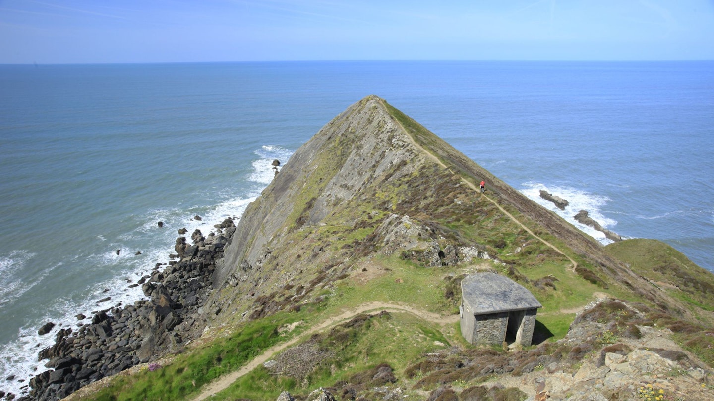
And if you’re missing having air on both sides of your boots, you’ll relish Sharpnose Points. The Higher is like a sea-going Striding Edge; the Lower has thin fins of rock, beloved by climbers.
Tiny, isolated coves make you dream of barbecues and swimming on hot summer days, but press on with the relentless ups and downs all the way to Bude, where the sight of its golden sands and a well- deserved pasty (you’ve crossed into Cornwall now, pard) signal the end of a spectacular day out.
Getting around: Buses connect Bude and Clovelly in about an hour; walking this section in either direction is of equal merit – but don’t underestimate those ascents.
2. Pendeen to Penzance

Distance: 41.8km / 26 miles
Elevation gain: 1,500m
Difficulty: Advanced
Even if you’ve never set foot there, you’ll have heard of Land’s End: the most westerly point of the English mainland (and the start of another very long walk, to John o’ Groats). But it’s the surrounding mining heritage, golden beaches and granite sea cliffs that steal the limelight on this 26-mile stretch of the SWCP from Pendeen to Penzance.
With 1,500m of ascent and some challenging terrain, this is a day or weekend-long Cornish odyssey for the strong of will and iron of leg. On the mile to reach the seaside from the start point of Pendeen, you’ll be pleased to learn the ground under your feet is like Swiss cheese: full of smelly holes and tunnels.
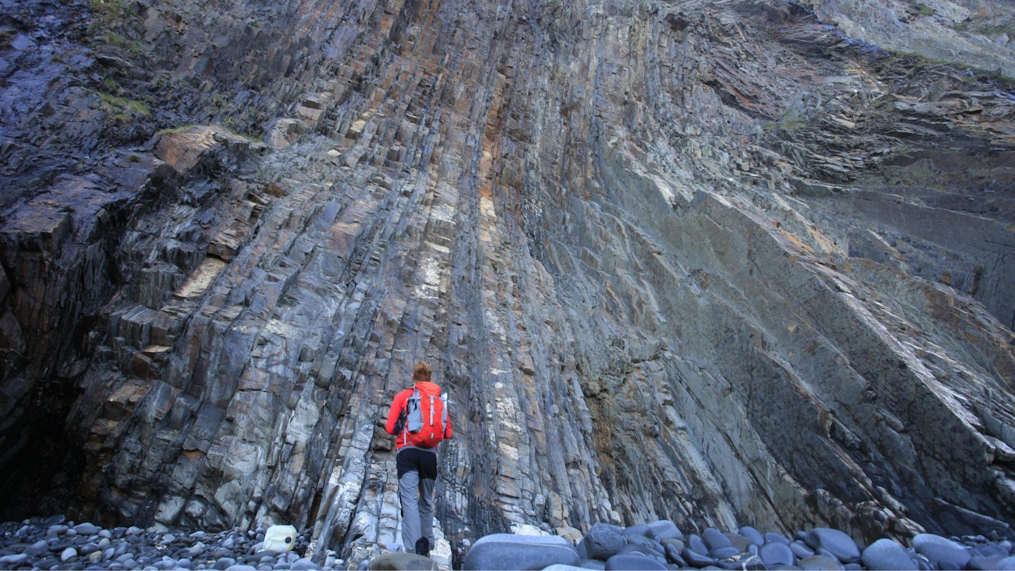
This is tin-mining territory and as you turn onto the coast path, the skeletal remains of the engine houses at Botallack begin to loom out of the cliffs; a stark reminder of Cornwall’s industrialised past.
From Botallack, the trail snakes towards Cape Cornwall, where the Atlantic divides around the headland – one current sweeping north, the other south. Unlike its famous neighbour of Land’s End, Cape Cornwall remains blissfully uncommercialised.
The next section of path takes you past the prehistoric tomb of Ballowall Barrow, and the ovoid-bouldered ‘dinosaur egg beach’ of Porth Nanven, and later down the long sandy bay to Sennen Cove, which is an absolutely gorgeous spot for a picnic lunch (or an Atlantic prawn baguette at the Old Success Inn).

Land’s End itself, unfortunately, is somewhere to scurry through. The scenery remains lovely, but the tourist complex that’s sprung up is, we think, best avoided. Beyond, however, the route truly shines, as it rattles along cliffs rattled by the Atlantic.
Later, you’ll pass over the Minack, an open-air amphitheatre hewn into the rock, where waves provide the soundtrack to Shakespearean dramas. The following descent into Porthcurno reveals one of Cornwall’s most exquisite beaches – all turquoise and gold, like something out of a holiday brochure.
If you’re doing this in high summer, expect both the coast path and the beaches here to be rammed; a swim will be more rewarding from the rocks at Penberth Cove a few miles further round.
The closing miles offer a gentler, more pastoral contrast to the craggy cliffs of the first half as the path weaves past Lamorna Cove and Mousehole, a fishing village where a pasty or an ice cream is compulsory (no quibbles).
Finally, the trail eases into Penzance, where a celebratory pint at a harbourside pub is well earned.
Getting around: Regular buses link Penzance and Pendeen in about 40 minutes, and there’s a national rail station at Penzance, making this epic coastal adventure easily accessible via public transport
3. Weymouth to Swanage
Distance: 46.7km / 29 miles
Elevation gain: 2,000m
Difficulty: Advanced
For those walking the whole trail from Minehead, the SWCP puts on one heck of a finale – which also makes one heck of a big day out. The hike from Weymouth to Swanage tots up 29 miles and 2,000m of ascent, so it’s a serious gig.
But for the low, low price of severe lactic acid build-up, you’ll admire Dorset’s chalk-white cliffs, prehistoric landscapes, natural rock arches, and hidden coves – all part of the World Heritage listed Jurassic Coast and set against the blue-grey drama of the English Channel.
Leaving Weymouth, the path soon starts climbing, offering sweeping views over the Isle of Portland. When you later reach the top of White Nothe, it’s well worth a down-and-back detour on the smuggler’s path to explore the undercliff, a lush Lost World created by prehistoric landslips.
The beauty of the white chalk massifs here never gets old, which is lucky, because you’ve got this sort of thing to look at for the next 20-odd miles. As you trek east, the route continues to show off its geological wonders like some sort of Jurassic prodigal child.
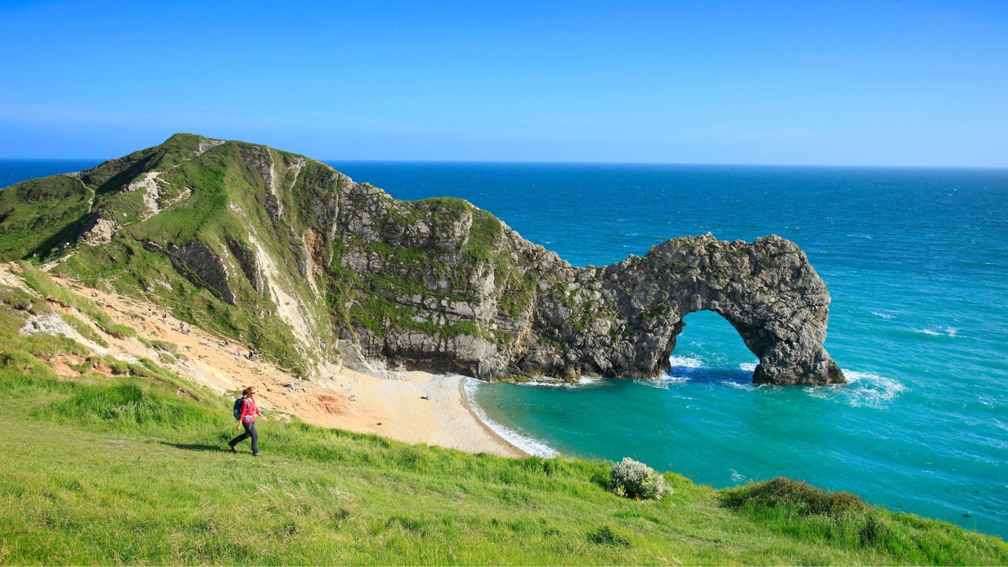
Soon, the iconic Durdle Door rises from the sea, a natural limestone arch that is one of Britain’s most photographed landmarks. Beyond that is the almost perfect circle of Lulworth Cove, with its rocks layered and crimped like puff pastry.

Then there’s the Fossil Forest, where 145-million-year-old remnants of prehistoric trees are embedded in the cliff – an eerie reminder that this coastline was once a tropical lagoon.
Carrying on past Worbarrow Bay, the trail leads to Kimmeridge. This is fossil-hunting heaven, with ammonites and ancient marine reptiles often found in the shale. The bay also boasts a unique snorkel trail, where underwater signposts guide swimmers through the marine life of this protected stretch of coast.
But bring your hammer and your flippers next time – you’ve got walking to do. The final stretch is no less dramatic. The cliffs rise and fall in a series of lung-testing climbs, eventually rounding St Aldhelm’s Head before descending towards the ancient limestone quarries of Dancing Ledge.
Here, Victorian quarrymen carved out tidal swimming pools, perfect for a quick dip before the last push into Swanage and the end of your day – or more relaxed weekend – in England’s Jurassic Park.
Getting around: Transport is trickier than the other sections – a bus between Swanage and Wareham, a train between there and Weymouth. Journey time is typically under two hours, but the two-car shuffle may be easier.
See it on screen
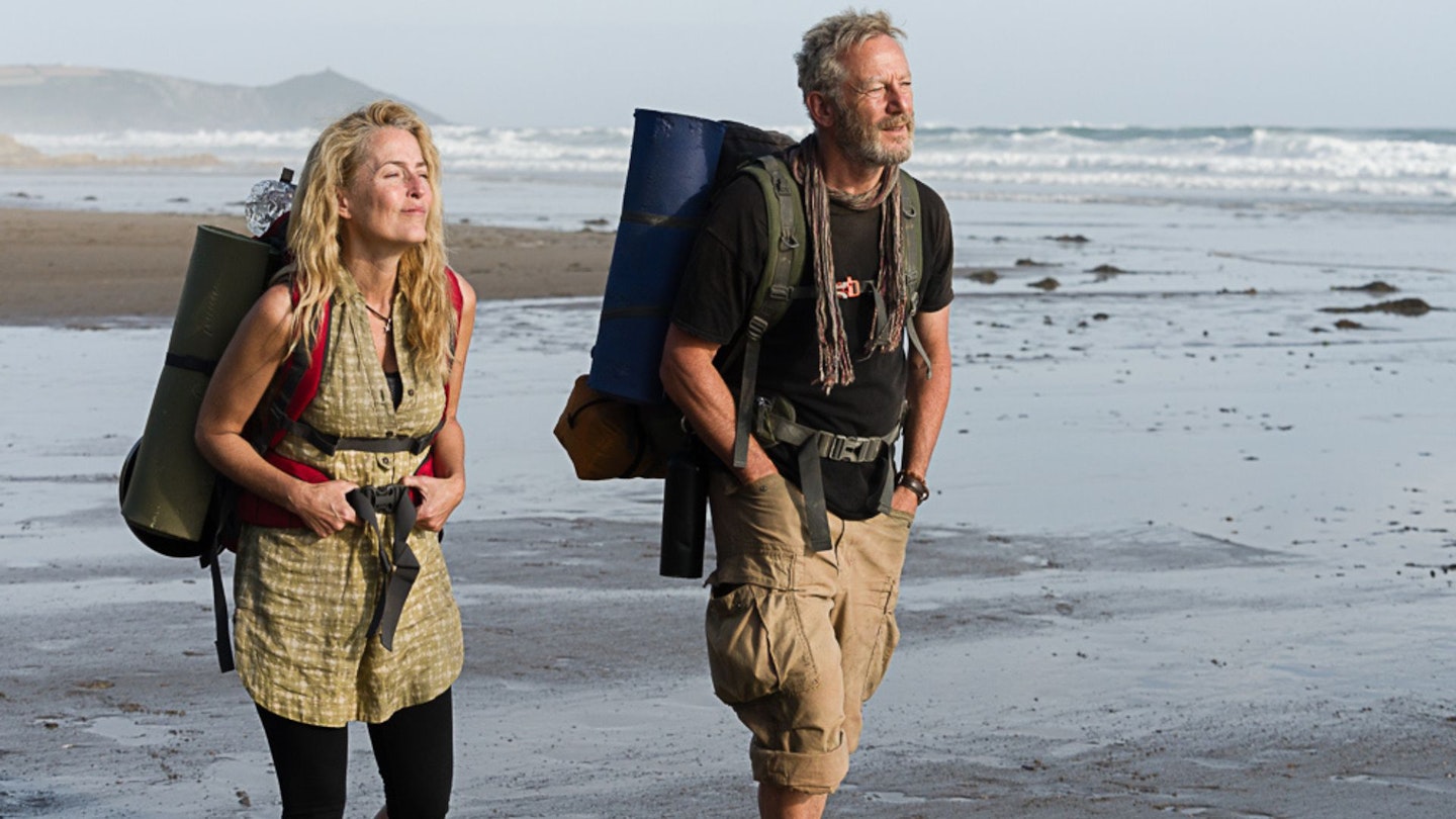
The film adaptation of The Salt Path, starring Gillian Anderson and Jason Isaacs, is set to bring Raynor Winn’s best-selling memoir to the big screen on 30 May.
It’s based on the true story of Raynor and her husband Moth, who, after the double blow of losing their home and receiving a devastating medical diagnosis, embarked on a transformative 630-mile journey along the South West Coast Path.
Directed by Marianne Elliott, the film captures their resilience, love and deep connection with the natural world, as well as the hostility they faced when people found out they were homeless.
Anderson and Isaacs lead the emotionally-charged story, but the third, titular character is really the trail itself, captured here by stunning cinematography.
Tempted to give the SWCP a go? Check out our guide on how to plan a long-distance walk.