%20or%20jm%20sc%20or%20(Twist%20RD%20PDF)-3.jpg?ar=16%3A9&fit=crop&crop=top&auto=format&w=1440&q=80)
Trail magazine’s 'Walks of a Lifetime' series takes you on a guided tour of the greatest mountain routes in Britain. This time we’re heading to the Southern Uplands of Scotland and White Coomb, with experienced mountain connoisseur Tom Bailey as our guide.
Click here to download this walk of a lifetime route from OS Maps
White Coomb is one of the stars of the Southern Uplands; that vast area at the base of Scotland. Combine it with the shapely Saddle Yoke, throw in one of the most exciting forest regeneration projects in the country and you have a galaxy of a mountain day. Oh, and the other brilliant thing is that you won’t be tripping over other people. In fact you’ll be lucky if you see anyone. This is one of those walks that builds to an epic, barn-storming climax. Broaden your horizons, push on those few more miles past the Lake District, and discover just how much there is to this part of the country.
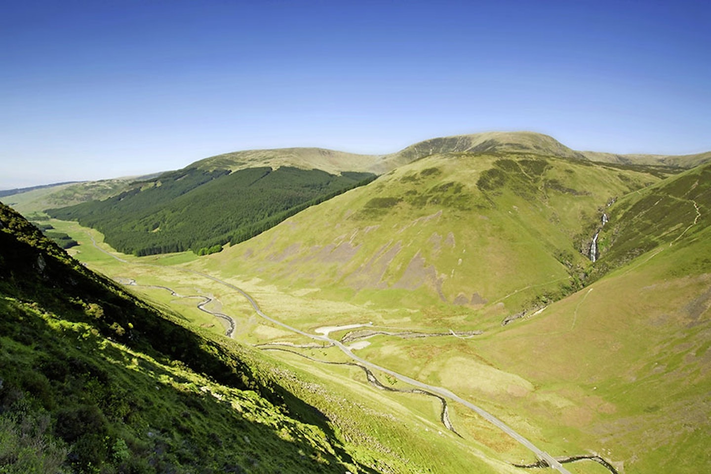
To walk it, park at the very foot of the ridge that bows down to the road from Carrifran Gans (map point 1, NT162116) – and yes, we are going to climb it. Trust me, it’ll be worth it. The truth is, it’s gonna hurt a bit, but don’t you just love those ascents that catapult you up and out of the valley, every footstep lifting you perceivably higher? It’s north for about 1km, then, as you clear Dun Knowe, the ridge, broad at this point, kicks slightly past north to make friends with the western quadrant of the compass. A change back to north after skirting the edge of some pretty serious crags and after about 500m you are at the first of three main summits; Carrifran Gans (map point 2, NT159139).
Below, to the west you’ll notice something wonderful; a glen full of broad-leaved trees. These native species have been successfully reintroduced, and make a real contrast to the miles of plantation that cover this part of the world. Now we all like trees, but as far as biodiversity goes, a plantation full of densely packed non-native species is a bit of a desert. Sure, they’re still doing their bit for CO2 absorption, but there’s more to the picture than that. In short this is a fantastic project and an inspiration. Search it up at ‘Carrifran Wildwood’ – it just goes to show what ‘normal’ people can achieve.
Once you’ve tired of Carrifran Gans, head north-north-west towards the enigmatically named Gupe Craig. As soon as the ground flattens out, head north-east for 1km. This will bring you to within touching distance of White Coomb. As you travel above Coomb Crag, saunter closer to the edge and take in the concave magnificence of the cliffs. At 821m White Coomb is a big lump in this part of the world, certainly the highest in the Moffat range. White Coomb summit (map point 3, NT163151) is capped with a historic cairn, and looks like it may have been a burial mound at some stage; a Bronze Age tumulus? I love the imponderables – I like the fact that the true answer to this may be lost in time. What is for sure is that just like a fox pooing on a prominent rock, we’ll always leave our mark on the highest in the form of concrete pillars or piles of stones. The views are far reaching, and both the Solway Firth and the Firth of Forth can be seen. That is in effect east and west coasts, which is epic. Loch Skeen can also be glimpsed partially to the north-east. This beautiful loch deserves a trip all of its own. It is on the main route up White Coomb, so is usually very popular.
This is a solid horseshoe walk, so you’ll never be out of sight of the Carrifran glen for long. Its beauty is such that you’ll soon get the reason for this route avoiding the main path up White Coomb and instead circling the glen. Who wants to do the expected? I just want to do the best.
Fences pretty much link the rest of the route. In winter the wires are bedecked with ice ornaments that grow into the wind at impossible angles. It’s always hard to resist the temptation to twang the wire and send hundreds of them crashing to the ground.


{#h-}
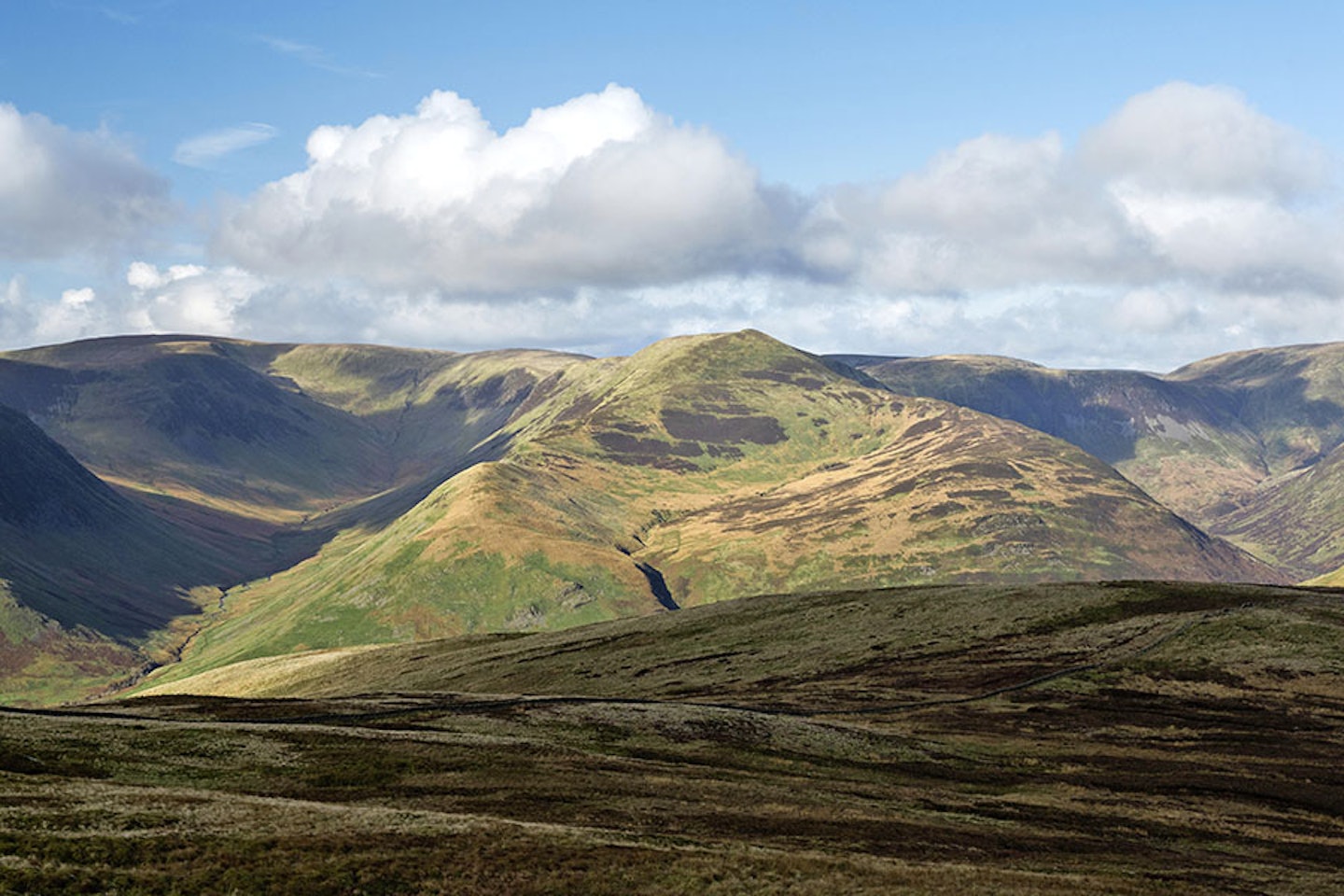
Firthope Rig (map point 4, NT154154) is a shallow mound 1km west-north-west from our friend ‘WC’. You may notice a high point to the north of you; Donald’s Cleuch Head. Cleuch is a local name for a gully – you collect far more than just peaks while walking our mountains. From this point, you get the longest view of the glen. The shapely form of Saddle Yoke struts its stuff, arm stretched into the sky in a defiant gesture. You can almost hear it stating “I’m Saddle Yoke” in a deep, booming, mountainous voice. We’re coming for you, but first we need to tackle Rotten Bottom. Yes, you’ve guessed it, we have to pass through the low ground between Firthope Rig and Under Saddle Yoke. The fence line can be a curse or a blessing in these situations, more often than not providing a bit of support from the sucking bog. Rotten Bottom (map point 5, NT144145) is laggy and just the sort of walk gaiters were made for. The way to deal with it is to just get stuck in and get it over with because the heights are calling.
Apart from the sticky bits, the route romps around covering ground quickly, all the time passing above the peregrine-haunted Raven Craig that towers above the head of the glen. As well as peregrines (and ravens), seeing a golden eagle is a real possibility here. Their numbers were strangely low in this bottom third of Scotland, for what is ideal country. A couple of years ago a project was started to boost the population of the bird that should be the mountain walker’s best friend all over the country; the golden eagle. Young eagles are being released each year until a self-sustaining population becomes an everyday sight here. It’s this glen, with its canopy of native broadleaved woodland, that you can imagine being home to a family of these birds. Seen up close, with the sun shining off it, the golden colouring on the back of the head and neck is a true delight, bringing the name of the bird to life and crowning it King – far superior to the ugly bulk of a white-tailed eagle (so say I).
Passing another col (map point 6, NT138134), the route swings south-south-east. We’re on it now, climbing up the northern slopes of Saddle Yoke. There’s no stopping us. These ‘highs’ are what we’re here for. Although lower than White Coombe, Saddle Yoke has the edge on looks and I’ve always been a sucker for a good-looking hill. Low directional sunlight brings out the pinched contours.
Once at the top of Saddle Yoke (map point 7, NT144124) look to the south-west. Unless the cloud is down, then you’ll be able to see Upper Coomb Crag on Swatte Fell. You can see into both valleys, the Carrifran and the Black Hope glen. This is an interesting exercise as the Black Hope valley is treeless in comparison to its neighbour. Draw your own conclusions…
There are two options from the top of Saddle Yoke, and we want the easterly one. Save the beauty of the south ridge for when you come back and do the horseshoe around Black Hope glen. The easterly ridge quickly broadens out, turning south onto the appropriately named Peat Hill (map point 8, NT153117). Opportunity lies at every part of a good walk, and here it’s time to take a long look up the Black Hope valley. As you lose height and get nearer to the road, drop to the east at the first safe opportunity. At map point 9 (NT156108) it’s now a trudge north-north-east along the foot of Peat Hill to the road bridge over the Carrifran Burn. A short stroll brings you back to the car.
With the boot of the car open, sit, boots off and look back up the ridge you climbed earlier. Scan to the left, see Raven Craig at the head of the valley, leading to the neck-craning Saddle Yoke. It’ll feel good to have those boots off, but there’s still a few hours of daylight left, so drive up the road and saunter up to Loch Skeen via the Grey Mare’s Tail. The tourists should’ve gone by now, so we’ll have the place to ourselves.


Fact file
WHERE DO I START?
Lay-by on the A708 (NT162116). The nearest town is Moffat.
WHAT’S THE TERRAIN LIKE?
You’ll tackle a mixture of steep grassy slope, moorland, boggy areas, road, plantation edge and broad flat moorland. Paths vague at times.
HOW HARD IS THE WALK?
Nothing here to worry anyone in terms of height or technicality, but these broad featureless hills can be tricky to navigate in low visibility.
WHAT MAP SHOULD I USE?
OS Explorer 330 (1:25k); OS Landranger 79 (1:50k)
WHERE CAN I STAY?
Dell Mar Guest House and the Buccleuch Arms Hotel in Moffat are both good options.
Click here to download this walk of a lifetime route from OS Maps

Get HALF-PRICE digital Ordnance Survey Maps for the whole of Great Britain by subscribing to Trail magazine.
Need help with OS Maps? Try the OS Maps online FAQ and OS Maps quick start guide for further assistance
