Trail magazine’s 'Walks of a Lifetime' series takes you on a guided tour of the greatest mountain routes in Britain. This time we’re heading to the Brecon Beacons of Wales and The Black Mountain, with experienced mountain connoisseur Tom Bailey as our guide.
Click here to download this walk of a lifetime route from OS Maps
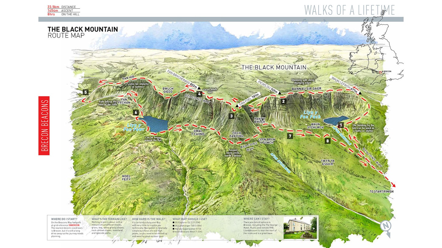
In South Wales, the Brecon Beacons National Park boasts many fine mountains. To the west of the region is the Black Mountain, a long, upside down L-shaped ridgeline. The northern and eastern cliffs form an immense geological feature, just made for walking above and beneath. Choose a sunny day and stride out, walking its whole length, high and low. You’ll return with that self-satisfied, long day in easy, spectacular mountains kind of feel. Never a feeling you can have enough of…
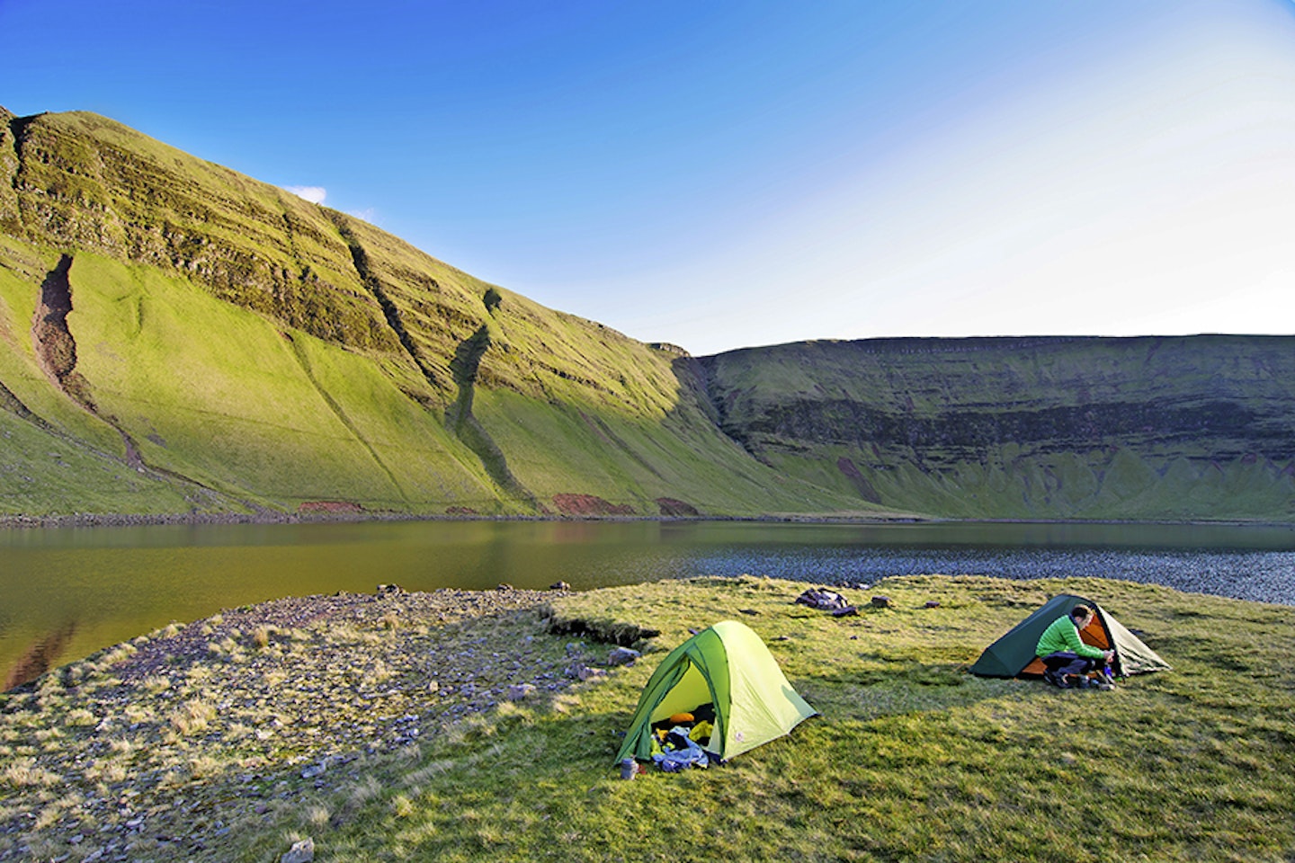
Starting this route from the north (grid ref SN800238) is slightly longer, but hey, we’re only talking a couple of kilometres and the remoteness of the walk-in more than makes up for it. After the 2km to Llyn y Fan Fach you’ll notice at map point 1 (SN803220) something you see quite a bit of in Wales; a building by a llyn. Clearly it used to be something to do with the dammed lake you’re now standing by and can be used as a bothy or shelter. It’s always handy knowing where these are, so mark it down for a future stay. It does have a fireplace, but no windows and no real sleeping platforms, just narrow benches, so you’d be kipping on the cold concrete floor. The last time I was there I noticed some graffiti that mentioned something about ‘muffin stuffers’, which might mean you could end up sharing it with some ‘characters’.
The views towards the head walls of Banner Sir Gaer and Picws Du are invigorating. Even in bad weather, the red sandstone beaches of the llyn give a warm feel to the coldest day. This is the reason for making the slight detour to the dam, rather than heading straight up the ridge to Waun Lefrith. Knowing a glacier hung in this valley, for once, seems easily plausible and eerily recent. On the way back, the view up here will knock you out all over again.
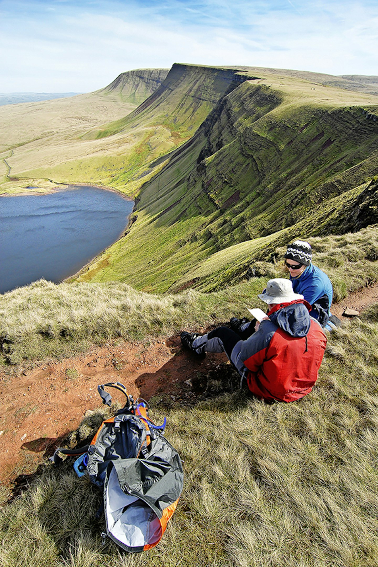
A westerly walk from the shelter shortcuts you to the ridge leading up Bannau Sir Gaer. When the path cuts to the south-east you should have startling views down to Llyn y Fan Fach and Picws Du. You’ll be feeling the vibe of this walk by now. This is what it’s all about; plunging edges with a contrastingly soft side to the ridge. It is country made for rattling along. You’ll be up and over Cwar du Mawr without even noticing, then you’ll devour the slight pull up to Picws Du (map point 2, SN812218).
There is no chance of over-egging the fact that the escarpment dropping away to your left for the whole length of the upper section of this route is stupendous. Old red sandstone makes up the majority of the mountains in the Brecon Beacons.
What gives the Black Mountain its distinctive cliff edge are the harder rocks in the ‘plateau beds’ that form the crust or top layer. Look at any of the cross sections exposed in the escarpment and you’ll see the striated harder rocks at the top, forming cliffs. In many areas there are vast moraines, elegantly fanning down from the steep sides, to add a softer feel to this warrior of an edge. Like most mountains, it’s under attack 24/7, although geological warfare moves at a very dull pace. The cliffs below you represent the resistance, standing steadfast in the face of the old enemy – time.


Picws Du is grassy and large. On the summit is an unexcavated Bronze Age cairn or burial mound. On the equally prominent Fan Foel, just over 1km away, there is one that has been dated to 2000BC. It doesn’t take a genius to work out why these spots were chosen; because of their commanding prominence in the landscape, they were surely the graves of important people.
Heading further east now, towards Fan Foel, the ‘northern nose’ of the Black Mountain as I call it, and why shouldn’t we have our own names for things? It’s a fair old pull up from Bwlch Blaen-Twrch to Fan Foel, the last big climb of the day. At map point 3 (SN822223), a flush with the ground circle of rocks marks the site of the prehistoric burial. This towers above a stone circle at the foot of the fine nose, directly to the north. Surely the two are contemporary?
Before we leave the subject, and indeed the mountain, it’s interesting to know that around 2000BC the climate was warmer. Vast areas of the uplands in England and Wales were populated. Indeed the hills would have been wooded and the landscape far richer as far as bio-diversity goes. Temperatures dropped in the late Bronze Age and again in the Iron Age, leading to the withdrawal from such lofty places.
From Fan Foel we ramp it up a gear as the path swings to the south-east, to follow the line of the escarpment, one that pivots around the ‘northern nose’. Another high point, indeed the highest of the day, is easily scaled; Fan Brycheiniog at 802m above sea-level (map point 4, SN825218). From here, the views to the south open up, and the area from about 500m and below turns into a minefield of shake holes – surely an indication of limestone country.
Dropping down to Bwlch Giedd, you clearly get to see Llyn y Fan Fawr. If you wanted to you could halve the route at this point, as a thin path snakes down the slope to the llyn. You could then return on the same path the rest of us will use later.
I think the summit shelter of Fan Hir, made of thin slabs of red sandstone, is a great place for a well-earned lunch stop. From here, for the next couple of kilometres the edge is straight. This gives a real contrast to the earlier curving, bulging cliffs. This one feels like the Romans made it (the edge I mean, because it’s long and straight).
There is so much high grassland up here that you must have heard skylarks by now, unless you’re here in the winter. They love high flat areas. We all know that towering song flight. One of the reasons for doing the walk this way around is the enjoyment of such a rompingly long descent. Let the legs go, get near to the edge, enjoy it.
The last couple of kilometres spread out and are easily done as you head to just above Ty Henry at map point 5 (SN846175). I love the fact that we’re swinging directly back up the way we came, only at the base of the edge. Don’t be under a false impression, the way back involves a good 400m of ascent but that comes over a long distance. Both paths we’re using today are high and low versions of the Beacons Way, a 159km trail through the National Park.
The cliff or escarpment edge continues to be our handrail, still on the left-hand side. By the time you reach the steep stuff, following the Nant Tawe Fechan, the towering nature of the grass and rock-strewn slope gets you going, in a different way from when you were above them but no less impressively.
A low ridge to the right of the river provides a course for the path. Upstream we go, up to map point 6 (SN832213), Llyn y Fan Fawr (big; if you remember your Welsh). In fact it translates as Lake of the Big Peak – this’ll refer to Fan Brycheiniog, directly above it.
The ground is a wee bit boggy around the shores of the llyn, but around it we must go, over to the jutting ‘northern nose’ of Fan Foel. When you get to the furthest point north on this section of the path, have a think about that stone circle I mentioned earlier. It lies only 400m away to the north, so if you’ve got the energy and you like your megalithic structures then you’d be mad to ignore it.
Around Tro’r Fan Foel (the ‘northern nose’) we go, back into the base of the escarpment, below the immense northerly face of Picws Du. At map point 7 (SN811222), ignore the straight-on route and take the left-hand path. This will give you another set of close-up views of the cliffs that now lay to the south of you.
At (map point 8, SN807222) it’s probably worth taking the right-hand track. This leads to the wide, gravelly route, which was the access road for the llyn back in the day when it was some kind of reservoir. Then, before you know it, you’ve got nearly 24km under your belt. After this day, the Black Mountain will be something to love, something that’ll conjure up long sweeping edges and wide empty surroundings. God I love this part of Wales.


Fact file
WHERE DO I START?
On the Beacons Way footpath at grid reference SN800238. The nearest decent-sized town is Brecon, but it’s still a long drive away so the journey needs planning.
WHAT’S THE TERRAIN LIKE?
Nothing to worry about, with a mixture of Land Rover tracks, grass, bog, steep grassy slopes, rock-strewn slopes, moorland, and lakeside paths.
HOW HARD IS THE WALK?
It’s certainly a long one! But with very little to trouble you technically. Navigation is relatively simple but these are still high peaks, so you need to be skilled up and wearing good outdoor gear.
WHAT MAP SHOULD I USE?
OS Explorer OL12 (1:25K); OS Landranger 160 (1:50k); Harvey Superwalker XT25 Brecon Beacons West (1:25k)
WHERE CAN I STAY?
There are lots of options in Brecon, including the The George Hotel. Rustic and remote YHA Llanddeusant is near the start of the route and is a great base.
Click here to download this walk of a lifetime route from OS Maps

Get HALF-PRICE digital Ordnance Survey Maps for the whole of Great Britain by subscribing to Trail magazine.
Need help with OS Maps? Try the OS Maps online FAQ and OS Maps quick start guide for further assistance
