-3.jpg?ar=16%3A9&fit=crop&crop=top&auto=format&w=1440&q=80)
Trail magazine’s 'Walks of a Lifetime' series takes you on a guided tour of the greatest mountain routes in Britain. This time we’re heading to the far northwest of Scotland, the mysterious Assynt region, and the iconic mountain of Suilven, with experienced mountain connoisseur Tom Bailey as our guide.
Click here to download this walk of a lifetime route from OS Maps
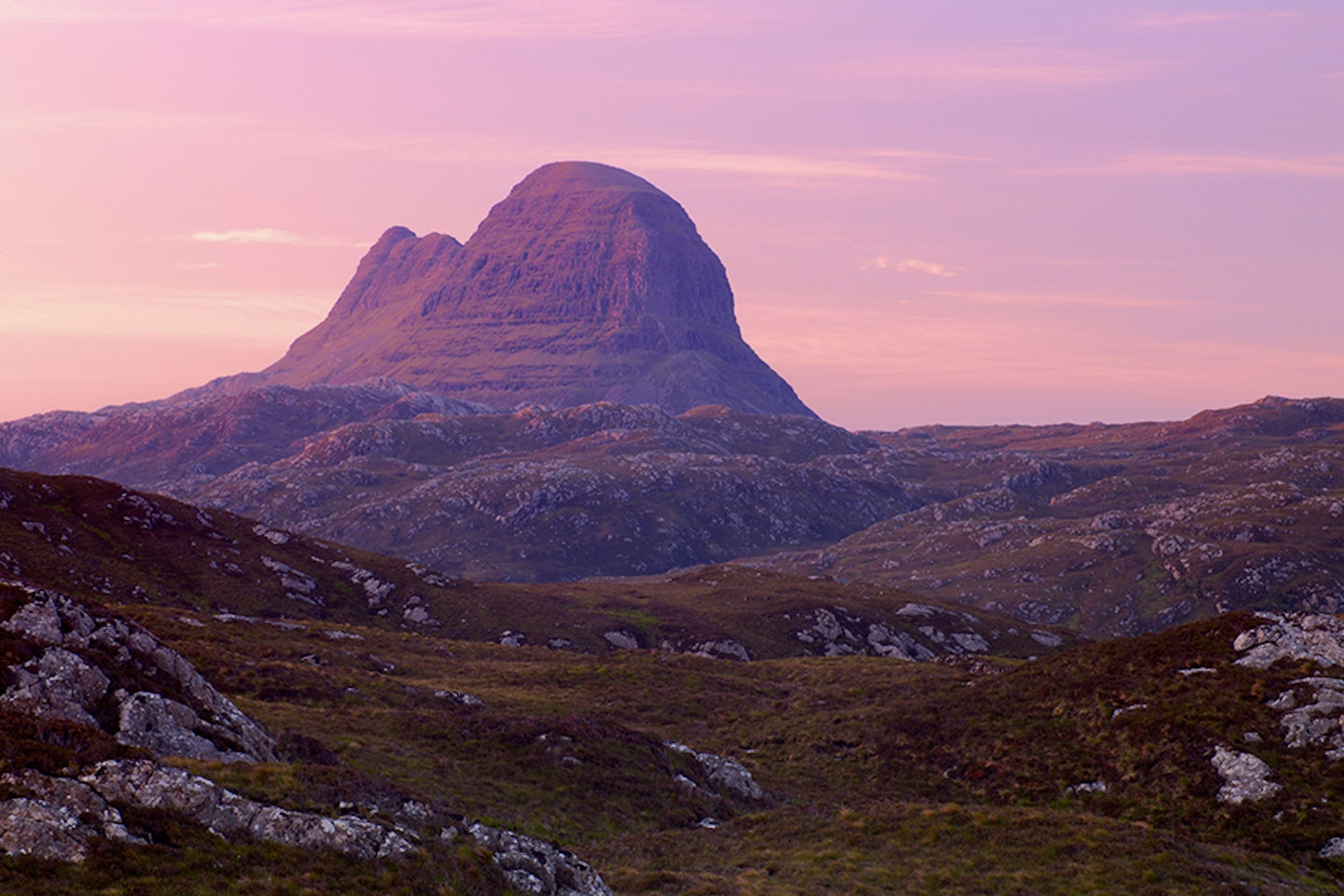
Suilven is the mountain we all fall in love with. I’ve never met anyone who didn’t like it, long for it even. Sticking out in a vast sea of lochan-pocked wilderness, Suilven has the presence of a great ocean liner. All the mountains in this region seem to rise out of nowhere to elegantly strut the catwalk that is the landscape of the Assynt. Suilven has the edge on the others though, with that effortlessly attractive quality – the lines, shapes, narrow at the eastern end, forming a plateau on the higher western end... It has it all. Suilven is simply one of those peaks you have to climb ‘because it’s there’.
The only problem with Suilven is that it’s a long way from anywhere. Luckily, it’s just about doable in a single day. Starting at map point 1 (page 116, grid ref NC107220), do everything in your power to get to the lay-by just before Glencanisp Lodge (there is space for around 13 or 14 cars). This will save you a good couple of kilometres each way, and on such a long walk in every little counts. Just before the estate you may well glimpse views of the western end of Suilven reflected in the loch south of Glencanisp Lodge. At map point 2 (grid ref NC116221) you pass to the north of the lodge, where there is an honesty shop open 24/7, so take some cash if you think you might need it. The path is easy, but rough in places after Glencanisp Lodge. It’s like some kind of rollercoaster ride from the 1950s – relentlessly, but never dramatically, up and down. But get you there it does. Your mind will wander further than your legs, particularly on the walk out, as you wish away the miles. The way in is filled with guilty views of this beauty. You and your friends will wear stupid, love-struck grins. Suilven looks its best from a three-quarters angle, and this walk in provides just such a view. Another place to fall in love is from the village of Elphin, over in the east. This gives you a similar perspective but from a 180° opposite direction. It may well have been your first view of the mountain on the drive in.


River and lochs
Map point 3 (grid ref NC166203) sees the Abhainn na Clach Airigh river crossed. It links the many lochans passed on the way in and deservedly needs a bridge. After the 7km walk along the relatively easy track, the path for Suilven swings to the south-west, heading for the mountain proper (map point 4, NC168196). This section of path has been the focus of a path restoration project over the last few years. Before that the path cut deep and wide into the fragile peat and on the north face things were even more interesting, but all that’s now in the past thanks to the efforts of the path builders. Imagine the effort involved: that two-hour walk in before you start a day of hard, cold, wet toil.
The way now is clear and dry. The path is a uniform 50cm wide, at one stage passing the preserved tree roots of a long-lost Scot’s pine. One glance at the map will tell you we’re in the Glencanisp Forest, but alas there are no living trees that I can see. This south-west trajectory leads up a couple of steep banks, passing between Loch na Barrack and Loch a’ Choire Dubh (map point 5, NC159187). This makes a great place for a pre-climb lunch break, as by now you’ll be about two and a half hours into the day.
Life-defining view
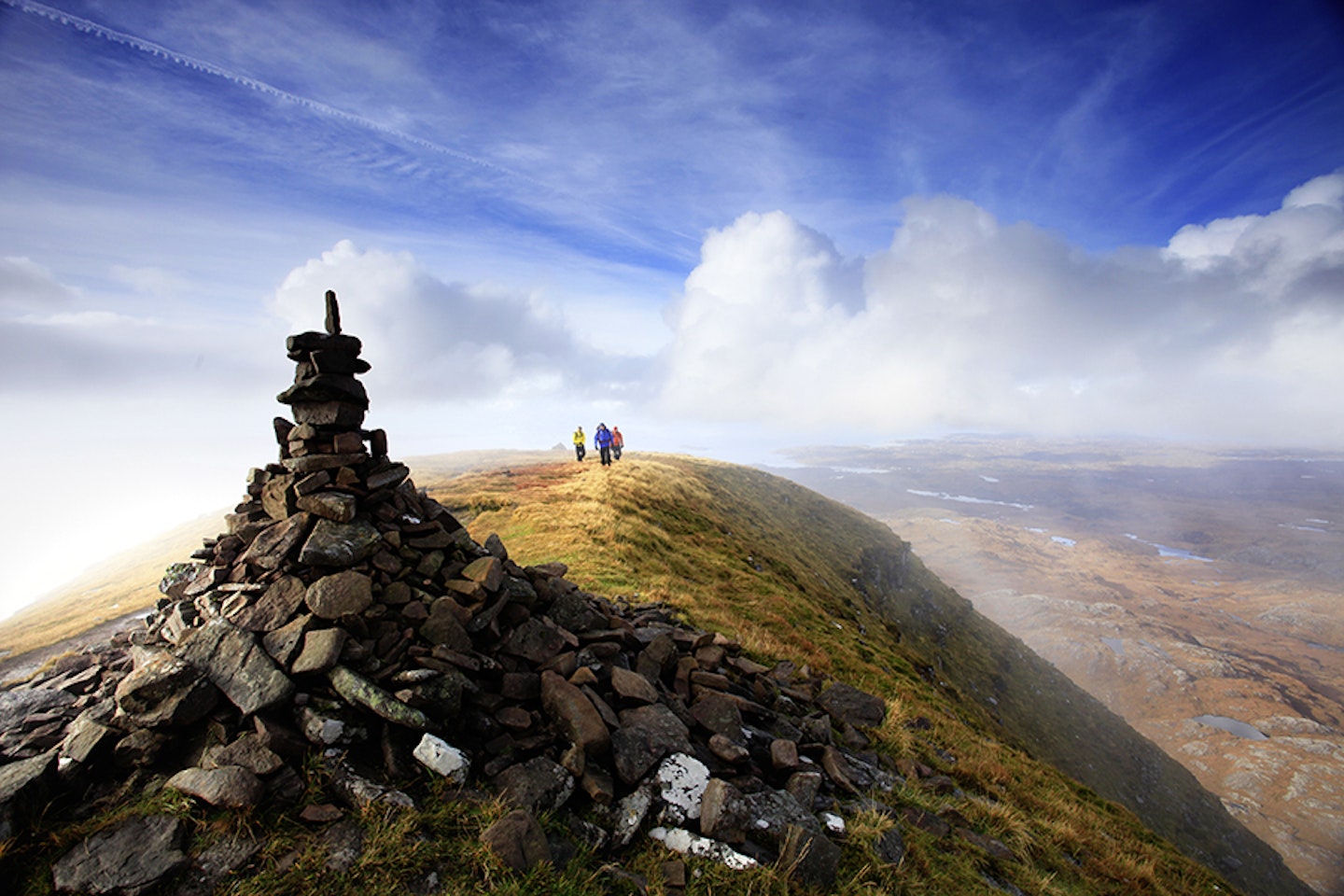
Leaving the lochans, Suilven itself is now to be tackled. The route heads roughly up the line of the gully to the bealach. On this steep ground the path restoration has been kept to key points where pitched stone steps make the going far easier than it once was. Prepare yourself. Cabin crew take your seats for take-off, because the view of a lifetime is ahead. Stepping over the cusp, onto Bealach Mor (map point 6, NC158181) is, if the weather is clear, a life-defining moment. Your approach from the north will at last make sense as you get the great reveal of nearby peaks Cul Mor (849m), Col Beag (769m), Ben More Coigach (743m) and, of course, Stac Pollaidh (612). All are linked by a measled land of blotchy, contagious-looking pools, probably reflecting the midday sun.
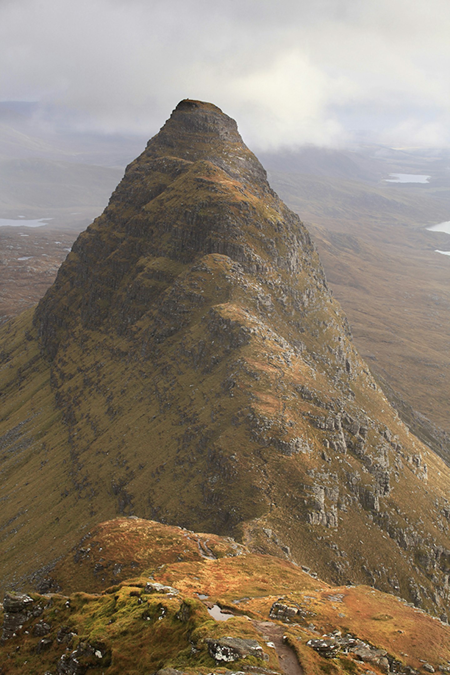
Turning west-north-west, the higher and more straightforward of the two summits, Caisteal Liath, is gained. An energetic path leads through a perplexingly well-made stone wall, giving views back to the eastern-most summit of Meall Meadhonach. A longer than anticipated climb gets you to map point 7 (NC153184) and the summit. Caisteal Liath (Grey Castle in Gaelic) along with the rest of Suilven, is made up of Torridonian sandstone. It sits in a surrounding landscape of Lewisian Gneiss (I know, I haven’t the faintest idea what that is either) and was shaped by the most recent glaciers, its teardrop shape being testament to this. Large and flat, it’s worth walking to the western end to make the most of the views out over the coast. The summit of Suilven would make one of the best wild camp locations in Scotland.


Head for heights
Heading back to the bealach, there is now a choice to be made: do you go for the other summit, Meal Meadhonach? The ridge to it is easy in a spectacular way, so I recommend you at least head along it until you reach the dip before the main tower. The first time I came to this mountain (20 years ago) I saw and heard my first ring ouzel on the crags of this peak. What a spectacular place to first see a new bird species. The very top of this high point is guarded by a rock band that can be scrambled, but you need a real head for heights as the climb back down gives sickeningly severe exposure, and there’s no other way off. So, this really is one for the brave.
The cairn lies towards the back of the small summit plateau (map point 8, NC164178). Turning back towards the bealach, whether you have or haven’t summited the beast behind you, you will at least be gifted with views of Caisteal Liath. Once back at Bealach Mor you start on the outward journey, retracing your steps all the way to map point 9 (grid ref NC149209). This will take a while, hence the reason for the diversion on the way back to Suileag bothy, as it breaks up the journey. A thin path threads through a bog to reach the low croft (map point 10, NC149211). Well worth considering for a future trip, this is a peach of a spot. Follow the larger track to map point 11 (grid ref NC148210), regaining the main track out to Glencanisp Lodge and the car park another kilometre further west.


Fact file
WHERE DO I START?
From the small car park west of Glencanisp Lodge near the small fishing village of Lochinver (grid refNC107220). Space for 13 or 14 cars.
WHAT’S THE TERRAIN LIKE?
A real mixture of road, track, bog, riverside path, steep and rocky mountain path, narrow rocky ridge, rocky plateau and a rocky scramble.
HOW HARD IS THE WALK?
This is a long but relatively straightforward mountain day, which looks longer than it is when you first start out. Though the scramble up to the eastern top should be reserved for experienced scramblers.
WHAT MAP SHOULD I USE?
OS Explorer 442 (1:25k); OS Landranger 15 (1:50k); Harvey Superwalker Suilven (1:25k)
WHERE CAN I STAY?
This is a remote part of Scotland, so accommodation is fairly limited. The nearby village of Lochinver is your best bet. Options include Lochinver Bunkhouse and the Culag Hotel.
Click here to download this walk of a lifetime route from OS Maps

Get HALF-PRICE digital Ordnance Survey Maps for the whole of Great Britain by subscribing to Trail magazine.
Need help with OS Maps? Try the OS Maps online FAQ and OS Maps quick start guide for further assistance
