-or-bw-jm-sc-(Twist-RD-PDF)-3.jpg?ar=16%3A9&fit=crop&crop=top&auto=format&w=1440&q=80)
Trail magazine’s 'Walks of a Lifetime' series takes you on a guided tour of the greatest mountain routes in Britain. This time we’re heading to the Scottish Highlands to take on the mighty Slioch above Loch Maree, with experienced mountain connoisseur Tom Bailey as our guide.
Click here to download this walk of a lifetime route from OS Maps
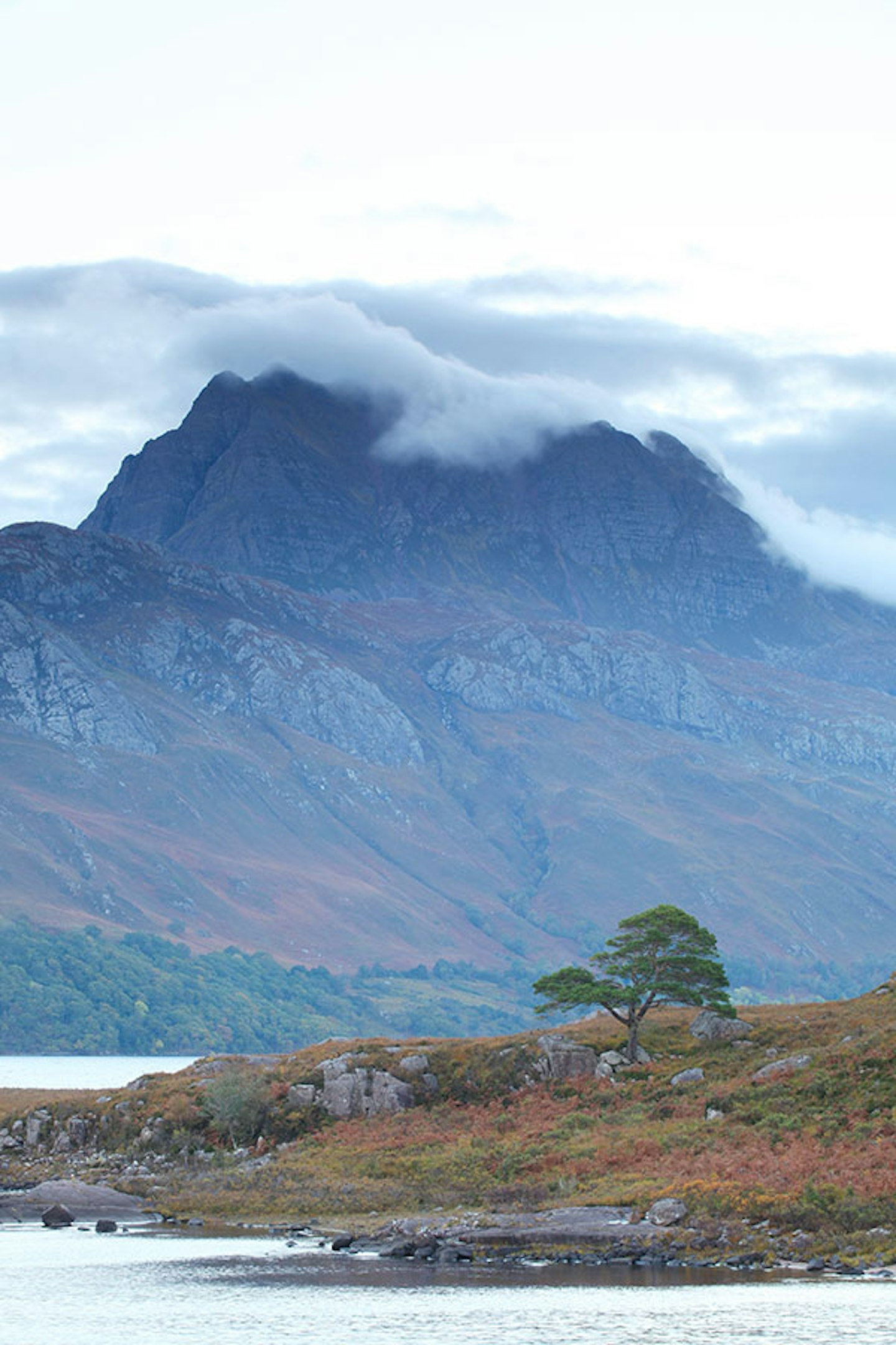
There are many things you should know about the British mountains, and one of those is that Slioch is the coolest of them all. It has the brooding presence of an indie band lead singer – the remote indifference, the looks, the muscle, the doesn’t-have-to-try talent. The name Slioch even translates as ‘spear’; enough said. Viewed from anywhere to the west, Slioch resembles an impenetrable and lofty fortress to the Gods. Maybe that’s what it is?
This is a remote peak, laying between two enormous lochs – Loch Maree to the south west and Loch Fada to the north. Although the A832 road runs along the southern shore of Loch Maree and you can get to within 2km of the peak by car, on foot there’s the small matter of 5km to cover before you even start climbing it. This only adds to the attraction. It’s brazen, yet remote, and it wants to be looked at, but not climbed. Flipping heck, Slioch has it all.
Long approach
Because of its location, this route will involve a bit of out and back. Though the setting is so fine and the going so flat for the first and last 5km that it won’t seem a chore or a waste. Park in the car park just less than 1km north-east of Kinlochewe (map point 1, NH038624). The path to Slioch now heads north-westwards, keeping to the northern edge of the fields and the foot of the steep ground.
For the first 4km you’re following the Kinlochewe River towards Loch Maree, the last 1km of which is alongside the more interestingly woody and wet start of the loch. The path rambles, passing through banks of bracken, undulating as it goes, as if to warm up the legs for the inevitable. Alder trees, which like to have their feet in wet ground, are numerous. Back in the day, if something needed to be made from wood, but had to withstand wet conditions, alder was the wood of choice.
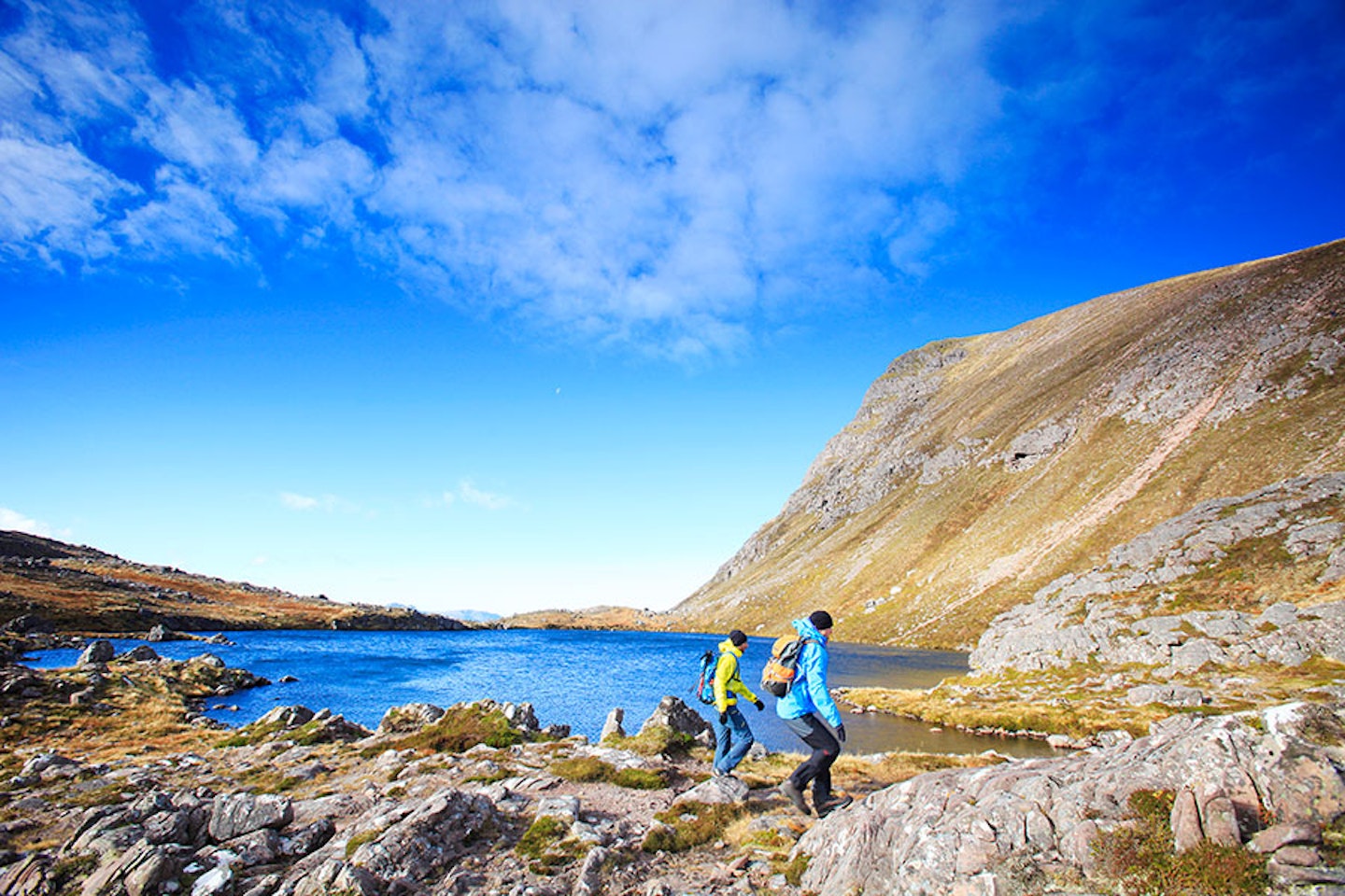
Loch Maree is the obvious star of the last section of the walk-in, although Slioch and its subsidiary peak Sgurr Dubh will have been glimpsed in front of you for a while now. Loch Maree is a wonderful place. Once I canoed out to some of the small islands that pepper this huge freshwater loch. The islands are a lost paradise, crammed with native trees, mainly Scots pines, which give you a real taste of how things once were, and how they could be again. Ospreys, divers and otters, not to mention countless other creatures, are all likely to be seen. Keep your eyes peeled.


The climb begins
Crossing the footbridge (point 2 NH012657), the path splits. It’s now time to head away from the temptations of Loch Maree and take the right-hand fork that heads up Gleann Bianasdail. Height is soon gained and within 1km you have the real sense that you’re pulling out of the glen and climbing the mountain. Looking back over the loch, the Torridon mountains – in particular Beinn Eighe – release their charms in a last-ditch attempt to lure you their way.
We’re heading for Coire na Sleaghaich, between Sgurr Dubh and the tiny Meall Each. It’s a stiff climb, but after such a long, flat walk-in, it’s actually nice to feel the pull of the ascent.
The heart of the mountain
When you reach point 3 (NH018677), Coire na Sleaghaich opens up fully. This again marks a split in our day. We’re going to continue in a north-westerly direction, heading for some lochans at the top of the rising ground to the north-west.
While still in Coire na Sleaghaich, it’s worth looking at the rough line of descent from Sgurr an Tuill Bhain. Understanding the lay of the land for later in the day, such as what features to look for, is always time well spent.
The path forwards leads through tussocky, boulder-strewn ground. It’s mostly easy-angled and non-threatening, with the flanks of the mountain around you appearing friendly and welcoming. Below a steepening, above which are the two lochans, the path rakes back south-south-west as it climbs efficiently up over the shoulder. The twin lochans (point 4, NH011681) sit just below the southern wall of Slioch. Here the ground contains more rock than vegetation. Ribs of it protrude near the water, allowing for some short scrambling to take the mind off the last bit of the climb. The path up from the two pools allows for a little more epic but easy scrambling, more a case of making it happen than needing to do it. This walk seems to be a series of rocky shoulders.
There is a lunar-like quality about the next leveling. Again, there’s water in the form of a much smaller lohan, surrounded by rock. The ground has a pink tinge to it, more from the soil. You’ll probably want to do a little dance at this stage, because looking ahead, the way to the summit is clear and easy, a shallow gradient to climb will put you within spitting distance of the top. One of the reasons Slioch is, in my opinion, a fine mountain lies in this ease with which you can now enjoy its splendors.
We’re also most definitely in golden eagle country and given clear conditions, the easy ground and lofty position give you ample opportunity to scan the skies.


Summit fever
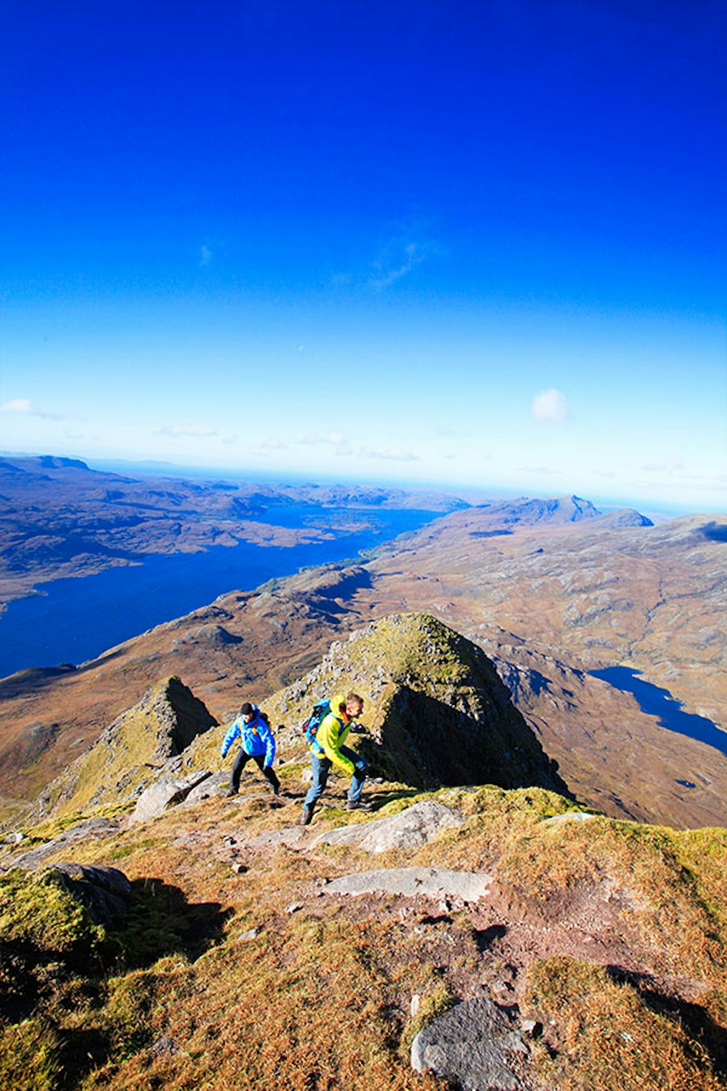
Inevitably, you’ll now feel the pull, the fever, that only the best summits give you. On top in a matter of minutes, I know you’ll do what I did – immediately walk the battlements of this fortress, looking down at the crags below. And they really do drop away, this is surely one of the more heavily-defended mountains on our islands. The summit (point 5, NH004690) delivers views that will get those smartphone cameras buzzing.
To the south and west, Loch Maree is the star. With its islands that make up a nature reserve, it is a unique loch. To the north, beyond Lochan Fada, is the Fisherfield Forest. Vast and full of all you could ever wish for, it’s a view that’ll plant a seed for future Scottish trips. There is an obvious ridge that comes up from the western side of Slioch. Obviously a scramble (Grade 2 or 3 depending on the route taken), it leads straight to the summit. This route is at the top of my scrambling to-do list one day!
The return journey
At the summit you’re a long way from the start. Bearing this in mind, that view to the west will have your back turned on it sometime soon. After all, there is another peak to come yet; Sgurr an Tuill Bhain.
Heading east-south-east from the summit, a pleasantly narrow ridge forms to connect with our next target. Shallow in gradient, it’s the perfect approach. The view back to Slioch when you reach Sgurr an Tuill Bhain (point 6, NH018689) is nearly as good as the vista seen from the main peak. What this view has that Slioch doesn’t is a dramatic foreground in the way of a narrow ridge, a great mid-ground in the peak you’ve just climbed, and a mighty Scottish Highlands backdrop. This is the walk that keeps giving.
Alas, the walk is also about to start talking, as the way back becomes the primary focus. Head initially south-east from the summit, following a thin path over short grass or scree for about 500m. At this point make a southerly swing, heading just to the east of Sgurr Dubh. Be prepared to lose this hard-to-follow path, with confidence in reading terrain and using a compass now essential. The earlier reconnaissance of the mountain’s flank proves its worth. On this section of the descent, the large north-west facing cliffs above Gleann Bianasdail are hard to look away from, with a regular banding giving them a slice-of-cake appearance.
Arriving back at point 3 (NH018677) it’s just a matter of retracing the way you came, turning south-eastwards by the loch then heading along the flat to the car park. A long, challenging walk, but not one to be forgotten easily.


Fact file
WHERE DO I START?
The car park north-east of Kinlochewe village at grid ref NH038624. The nearest town is Ullapool, around an hour away by car.
WHAT’S THE TERRAIN LIKE?
It’s a classic Scottish mixture of valley paths; boggy paths; rocky, grassy and narrow mountain ridges; loch-side paths; stream-side paths; scree; short grass and rock.
HOW HARD IS THE WALK?
Slioch is an exposed and high mountain with little shelter. The route itself poses little technical difficulty, but it is long and tiring and needs good navigational skills, particularly in poor visibility. Definitely one for experienced hillwalkers.
WHAT MAP SHOULD I USE?
The OS Explorer 435 and Harvey Torridon Superwalker maps cover the route in 1:25,000 scale, while the OS Landranger 19 map (Gairloch & Ullapool) covers the route in 1:50,000 scale.
WHERE CAN I STAY?
The Kinlochewe Hotel and bunkhouse is located near the start of the walk, while the Torridon Inn (quite fancy) and Torridon Youth Hostel (not so fancy) are further away at the head of Loch Torridon. visittorridon.co.uk
Click here to download this walk of a lifetime route from OS Maps

Get HALF-PRICE digital Ordnance Survey Maps for the whole of Great Britain by subscribing to Trail magazine.
Need help with OS Maps? Try the OS Maps online FAQ and OS Maps quick start guide for further assistance
