Trail magazine’s 'Walks of a Lifetime' series takes you on a guided tour of the greatest mountain routes in Britain. This time we’re in Cumbria to explore the rolling green hills and valleys of the Howgill Fells, with experienced mountain connoisseur Tom Bailey as our guide.
Click here to download this walk of a lifetime route from OS Maps
If the Lake District is the honey pot and the Yorkshire Dales the jam pot, then the Howgill Fells must be the marmalade pot. No less sweet; just not to everybody’s taste. In fact, I would go as far as to say, a superior, more complex, subtle flavour. If you want a sense of oneness with your hills, if you’re sick of the crowds to the west, then the Howgills are for you.
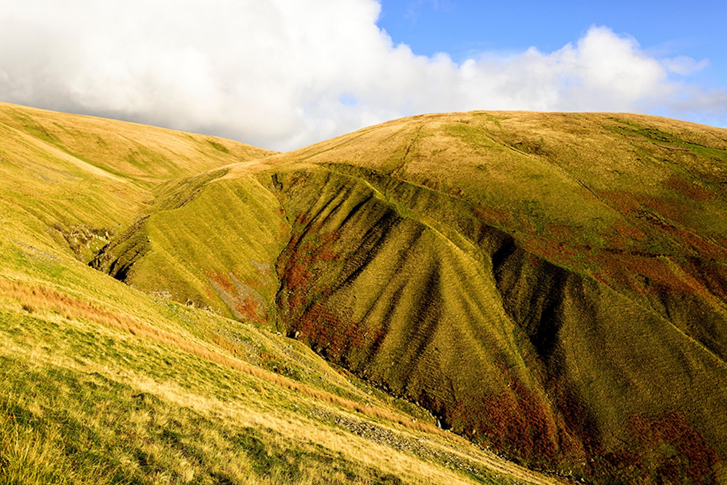
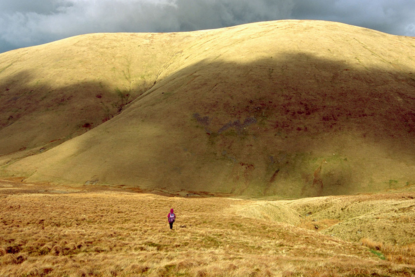
Wainwright described these hills as looking like a herd of sleeping elephants, and for once I would have to agree with him (just don’t tell anyone). The grass that covers the full, rounded hillsides does indeed look like the stretched skin of a large animal, forming creases where the numerous cloughs drain the slopes.
There are many ways to tackle these unique hills. I’ve walked north from Sedbergh, straight up, onto, then back down. As a north-south traverse, I crossed the Howgills with a wild camp in winter, and remember following fox tracks for mile upon freezing mile. Or, as we’re about to discover, they can also be walked, wonderfully, from the east…
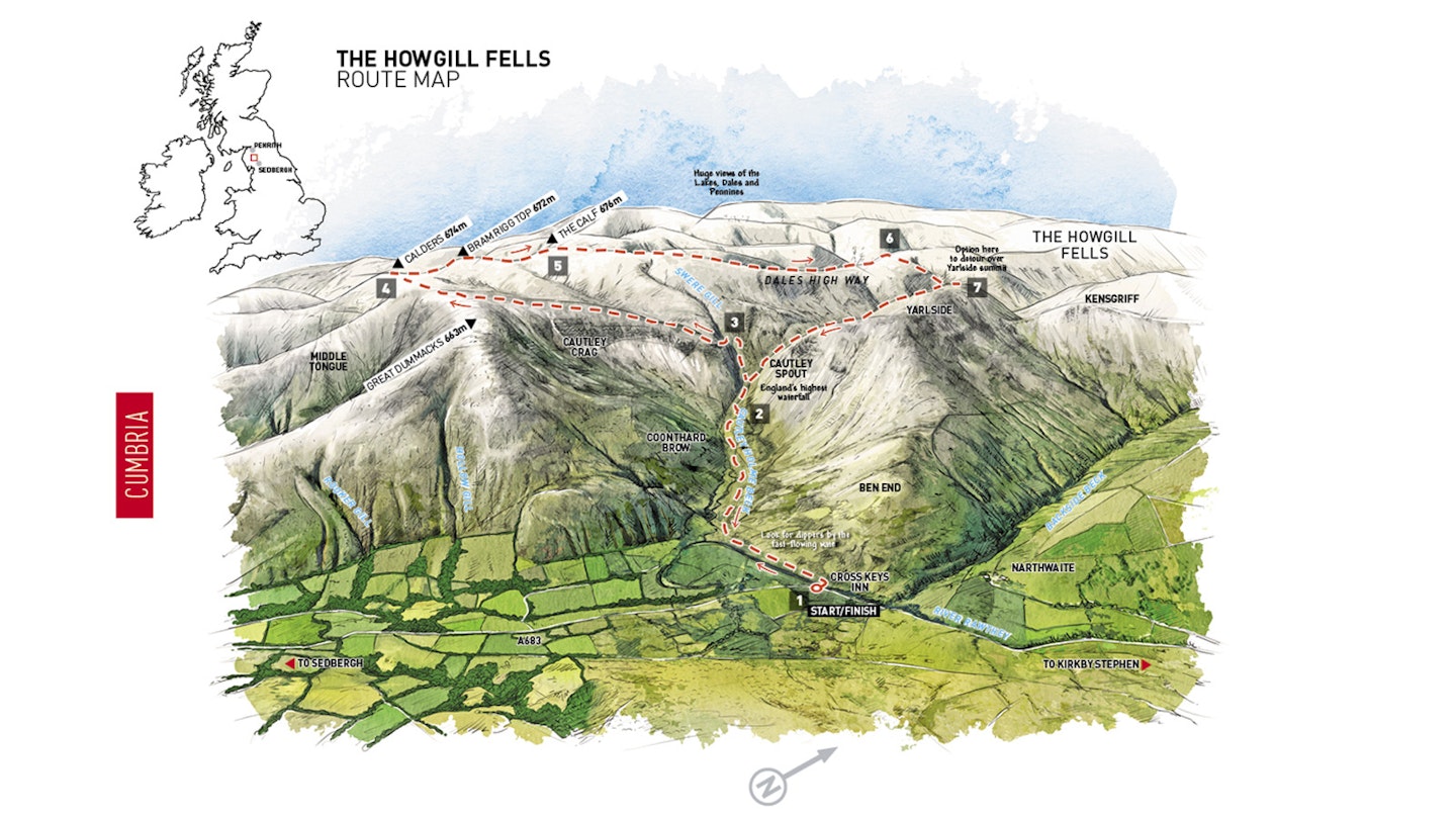
Parking near the Cross Keys Temperance Inn (map point 1, grid ref SD698969), head to a footbridge just north of the pub. If, like me, the thought of a pub that doesn’t sell booze leaves you cold, take solace in the fact they let you bring your own alcohol.
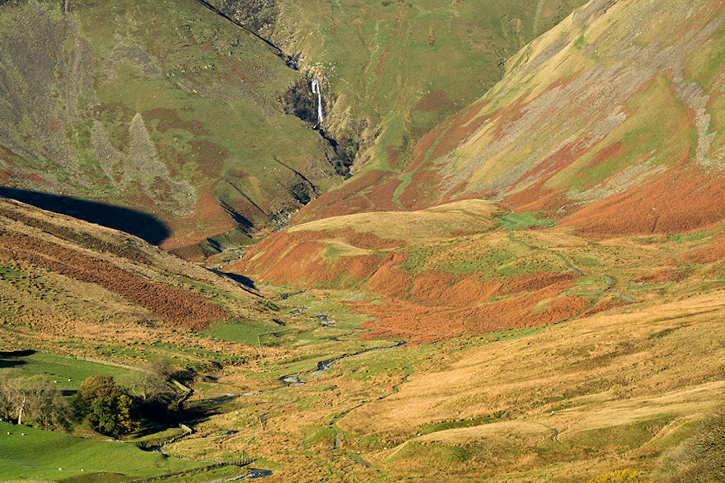
Cross the impressive River Rawthey, keeping an eye out for dippers (those small, white-breasted, bobbing birds of rocky rivers) as you turn west-south-west following the bank for 500m downstream. If the cloud isn’t down, you should be well aware of the rather large Cautley Spout waterfall at the head of the valley, which is reputedly England’s largest with a drop of 180m.
Rather than fall in one continuous curtain of water, Cautley Spout bounces from rock to rock in a series of steps. Follow the Cautley Holme Beck north-west towards the falls. The high cliffs of Cautley Crag dominate the walk-in. This is as rocky and severe as the Howgills get. The rest, as you will see, is far more friendly – as if the hills couldn’t quite bring themselves to be without just one crazy mountain feature.

At point 2 (SD684974), the terrain is about to steepen, so take the left- most of the two paths and head up the northern bank of the river. There are several great vantage points where Cautley Spout can be seen at its best, up close and personal. The break is welcome, as your lungs and legs will be working hard by this point of the walk.
The contours ease back as you reach the top of the falls. Turn to the south-south-west and cross first Swere Gill, then Red Gill Beck (point 3, SD679974). At these two streams take care not to cross if there’s been an excessive amount of rain, because for obvious reasons you don’t want to be riding the falls. If such conditions did stop you, heading westwards before Swere Gill would at least get you to the top of The Calf, from where you could continue with the rest of the route.
Presuming all is well, head south, climbing along the top of Cautley Crag. Gut-clenching views down to the valley from where you came are giddy rewards for the work so far. One June, 15 years or so ago, I bivvied out on this ridge. Thor, the God of Thunder, arrived in the middle of the short night. As the rumbles got nearer I could bear it no longer – out of the bivvy, in my pants, I cowered, off the ridge and down into the clough. As wet as I was, I was at least alive and, it has to be said, pumped! There is nothing like a closely observed storm to give your immediate future perspective.
The hump of Great Dummacks (663m) is soon reached and it’s here that a turn to the south-west takes you over the Top of Middle Tongue, across the broad grassy tops to Calders (674m) at point 4 (SD670960). By now it’s fair to say you’re experiencing the real character of these pert hills. It’s a joyous romp across the tops, and with the real work done you can enjoy the miles ahead at your leisure. Low sun offers the best conditions in which to see the Howgills. Their bulging, slightly-too-full nature allows light to skim seductively across every curve, creating deep, shadowy valleys.
A turn to the north-north-west from the summit of Calders leads over Bram Rigg Top, after making a short detour. The afternoon before the aforementioned thunderstorm, I’d laid down in the grasses on this fell top. From behind me, six inches above the grass stems, swifts (those sickle-like, screaming birds of our towns) whooshed past, their blade-like wings audibly cutting the same air I breathed. Such moments you don’t forget.
Continue in the same direction, dip into a shallow col, then ascend the last few metres to the grand summit of The Calf (676m) at point 5 (SD667970). This is the high point of the Howgills.
The very name Howgills is derived from the old Norse word haugr, which means ‘barrow’, ‘hill’ or ‘gill’, which refers to narrow valleys. It’s nice to know Thor himself had a hand in naming these fells (and yes, before you email, I know the word fell is derived from the Norse word fjall, meaning mountain). From the summit of the Calf, you can clearly see the Lakes to the west, the Dales to the south and east, and the Pennines to the north, all seemingly within walking distance.
Walking north-north-east from the top of the Howgills, you meet a wide and sweeping ridgeline that descends leisurely enough for you to enjoy views of the range. Swinging north for another pleasant kilometre, keep a keen eye out for the shallow hillock that signals the start of the real descent (point 6, SD673989).
Hazel Gill serves as a marker. Nearly 200m is lost in half a kilometre, bringing you to a junction of streams. Turn southwards, staying on the western bank of the river. This valley journey contrasts starkly with the wide-open fellsides just walked. The immense bulk of Yarlside grows to your east, and if you’re feeling fit then point 7 (SD679995) is the time to give this shapely hill a go, because the ridge can be followed almost to the start of the walk.
If you’re staying with the river, pass Bowderdale Head and descend the steepening stream that drops you back into the original valley on the path that revisits point 2. From here, it’s a simple task of retracing your steps back to the Cross Keys Inn for a stiff orange cordial chaser.
Howgills fact file
WHERE DO I START?
The 400-year-old National Trust Cross Keys Temperance Inn. There’s a lay-by to park in beside the A683 road at grid reference SD698969.
WHAT’S THE TERRAIN LIKE?
The Howgills are generally very rounded and unthreatening, with a mixture of valley paths, steep grass paths, bogs, grassy slopes, broad high mountain ridges, streamside paths, and mountain stream crossings.
HOW HARD IS THE WALK?
Technically not difficult at all, but the Howgills are fair-sized hills that get their fair share of rough weather. You need decent fitness, the ability to navigate in poor visibility on featureless tops, and the right gear to combat everything from rain, snow and wind to scorching sunshine in high summer.
WHAT MAP SHOULD I USE?
The OS Explorer OL19 map and Harvey Superwalker Yorkshire Dales North West map both cover the whole route in 1:25,000 scale, while combining the OS Landranger 91 and 98 maps does the same at 1:50,000.
WHERE CAN I STAY?
There are rooms available right at the start of the route at the Cross Keys Inn (book early), while the Howgills Barn in Sedbergh is a great option for booking either single beds or the whole hostel with large groups (it even has its own hot tub!). Kendal, Kirkby Stephen and Dent are all close by.
Click here to download this walk of a lifetime route from OS Maps

Get HALF-PRICE digital Ordnance Survey Maps for the whole of Great Britain by subscribing to Trail magazine.
Need help with OS Maps? Try the OS Maps online FAQ and OS Maps quick start guide for further assistance
