-3.jpg?ar=16%3A9&fit=crop&crop=top&auto=format&w=1440&q=80)
Trail magazine’s 'Walks of a Lifetime' series takes you on a guided tour of the greatest mountain routes in Britain. This time we’re heading to Snowdonia and the magnificent Glyderau for the Bochlwyd Horseshoe, with experienced mountain connoisseur Tom Bailey as our guide.
Click here to download this walk of a lifetime route from OS Maps
The Ogwen valley in Snowdonia is home to many shattered, rock-strewn mountains. The most prominent of these is the mighty Tryfan. An ascent of this iconic peak, combined with Glyder Fach’s Bristly Ridge and a descent of the Y Gribin ridge weave a mountain tapestry of ‘Bayeux’ proportions. In fact, it’s one of the most enjoyable, fun days to be had in the British mountains – especially if you like getting your hands on rock.
This is an out-and-out scrambling day. Most of it is Grade 1, although there are parts of Bristly Ridge that push this to its very top end. So prior scrambling experience is a must as there’s loads to get through on this mountain gymnasium of a route. There is always, however, a yin to any yang. A darkness to any light. And this route is no exception.
Parking at map point 1 (page 116, grid ref SH663603), you’ll notice straight away how busy these lay-bys are. This is the downside – the route is so popular that not only will you have to jostle for a parking spot, you’ll also rarely be alone on the mountains. For the loners out there (and I’m one), be prepared. Don’t ditch the route, instead just accept from the get-go that you’ll see all of the craziness of the human population on this day. For the rest of you slightly more balanced people, revel in the comradery of a fun day with shared dangers and group highs. You’ll see plenty of smiles.
Steep start
Leaving the car, go through the gate in the stone wall, following a clear, well-trodden path on the left of a wall perpendicular to the first. This will be the last of the straightforward you’ll encounter for a while.
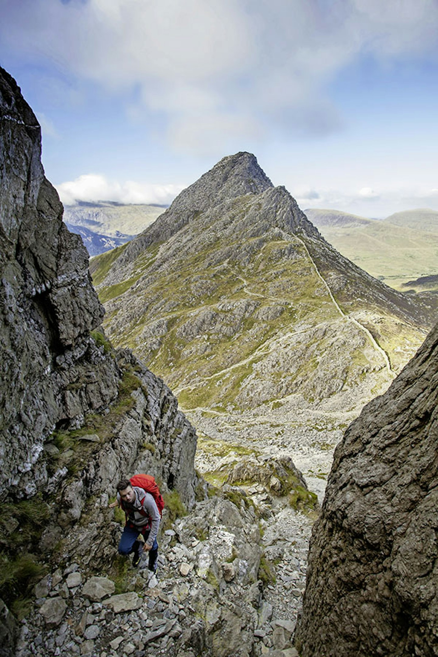
The path steepens and pulls around to the south side. At around 430m (remember you started at about 300m) the true north ridge of Tryfan opens up before you. Clear lines of travel, due to this being such a popular route, enable relatively straightforward route-finding. The golden rule is to stay on the crest of the ridge, stay within the limits of Grade 1 scrambling, and you won’t go far wrong.
To describe each and every move would be tedious and repetitive because there is so much of it. Simply enjoy the trip, because you’ll never climb another mountain in quite such a fun way again. I still vividly remember my first time.
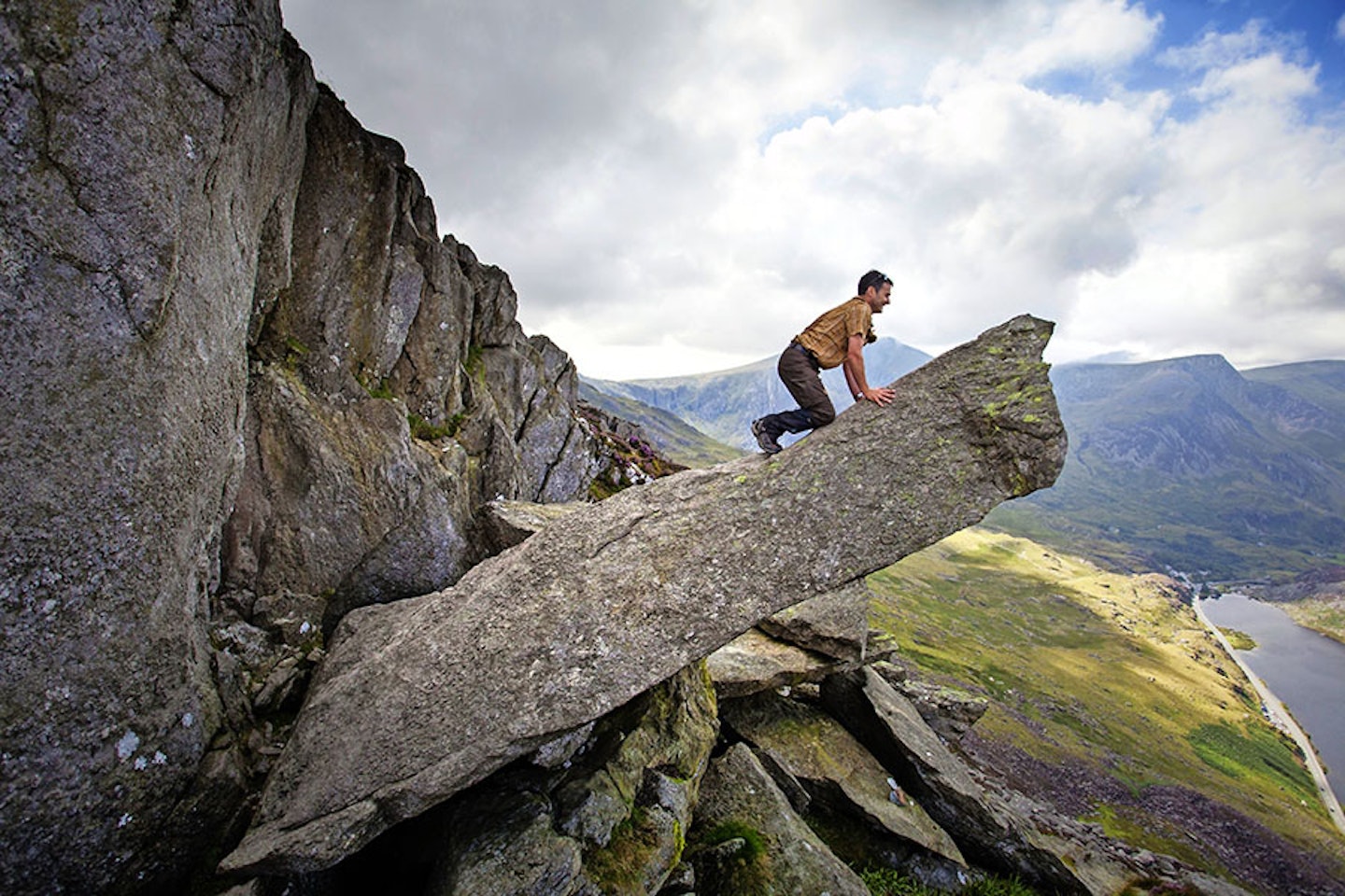
There are points where the angle lessens between bouts of scrambling. It’s on one of these, around about halfway up, that you may notice the rather well known ‘Cannon Stone’. Here, the daring among you will savour the first of three must-do photo opportunities along this route. Slide along the length of the ‘barrel’ and sit on the end of it while a friend or one of the many passers-by takes the pic. Job done, continue on up.


Adam and Eve
Towards the top, the route constricts into several rocky towers, the options become less and you have to commit to the only route up. This is still within Grade 1, but is the hardest part of the north ridge. The summit of Tryfan (map point 2, SH664594) will be betrayed by the ‘twin towers’ of Adam and Eve, the two monoliths that dominate the top of this rocky, brutalist, structure.
You’ll never see more grey rock than on this day out. Photo op No. 2: an action shot of you jumping between Adam and Eve. I did this on my first ascent, many years ago, and I’ve always refused to do it again. I’m not sure why. Maybe it would water down the elation I felt on my first ascent. Or maybe I’ve gone a bit soft…
Moving directly off the summit to the south-south-west, you’ll step over an awkwardly airy rock band before heading down the predictably rock-strewn, but not scrambly, route to the pass at Bwlch Tryfan (map point 3, SH662588).
I’ve done the descent just described in winter conditions and the boulderfield covered in snow was a complete pain in the backside. You never knew which footfall would land on rock, or which would reveal a leg-jarring gap between the boulders. This col is a good place for a break as a wall runs along it, giving shelter should you need it.
Bristly Ridge
Now comes Bristly Ridge. Follow the wall in a south-west direction towards Glyder Fach. You’ll climb quickly on a rough track – again, many people have been this way. At least three gullies look down on you, and it’s hard to tell once you start looking what really constitutes a gully.
The route passes through the wall and you take the gully encountered after this, where the signs of traffic are obvious. This is Sinister Gully and provides the best/safest scrambling. A chock stone, which can be climbed over, is soon reached and gives confirmation you’re in the correct gully (remember this).
Things do eventually lead to a ridge, but the ‘bristly’ part of it doesn’t really come until the top section. You’ll have to enjoy some rather fine scrambling first. Oh, and beware of men in very short, brightly coloured, wide, gaping shorts. I’ve seen many on this route over the years. To you all I say this: “Do us all a favour and don’t inflict your mesh-cupped genitals on us.” The perils of scrambling are many!
At about two-thirds of the way up, there’s a tower to climb down. Very slightly to your left is a series of ledges which make for a safe way down this. The route soon reaches its true potential and lives up to its name, as it takes on a rather bristly appearance. It ends in epic fashion with easy scrambling in a high, showy way. Tryfan looks on rather jealously in the background, as you’ll probably realise you enjoyed Bristly Ridge even more than Tryfan’s legendary offerings. Ravens seem to suit this location. A common sight in the mountains, their antics in the air in places such as these take on a sublime, memorable quality.


High point of the day
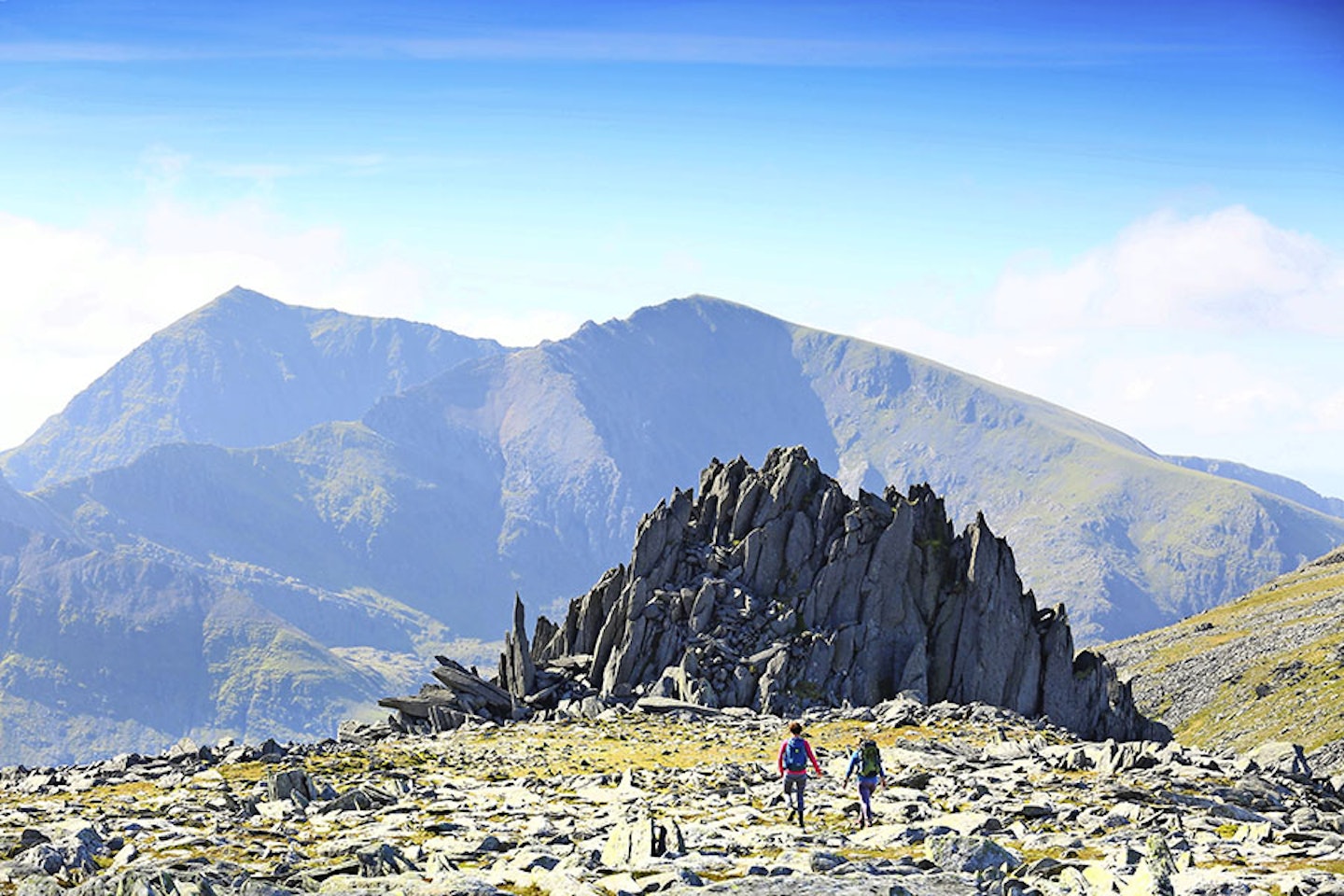
The summit plateau of Glyder Fach is now beneath your feet. There is no other place like it in Wales, dare I say Britain? Monolithic stone pillars are scattered in all directions, sometimes forming the shape of a crown. It’s like a prehistoric Stonehenge factory.
A south-west bearing brings you near to the summit, but before you bag it the third and final ‘must-do’ photo op awaits. The Cantilever Stone is a large rabbit’s tooth of rock lying on its side, balanced see-saw fashion, with no prizes for guessing what you do in the photos!
The summit (map point 4, SH657583) is a faff to get to. A raised boulderfield, made up of car-sized blocks of rock with gaps that could easily swallow you, awaits. Once on the summit nothing marks the spot, other than the traces of some long-gone structure.
Castle of the Winds
Navigation in bad conditions is tricky up here, so pay attention to the map. The path is easily missed when walking over boulderfields. Keeping in a south-west direction: if it’s clear, you’ll have one of the finest views in Snowdonia in front of you – the view towards Snowdon itself. The thing that makes it is the foreground, and more precisely Castell y Gwynt (Castle of the Winds). This rock fortress guards the lower western approaches to Glyder Fach. Scramble up its east face, admire the view, feel great, then follow a steep path down the western side.
At map point 5 (SH652582) you’ll reach Bwlch y Ddwy-Glyder, and heading west from here you need to fork right, handrailing the cliffs to the north-east. This pops you out on the final bit of fun, the descent of Y Gribin ridge. A path is available, mostly on the western side of the crest.
However, if you’ve got a bit of scrambling left in you, the ridge proper can be done, at least until it starts to break away to the north-north-east, then reconnect with the main northerly path on Y Gribin. Follow this lower section of the ridge.
Wild swimming spot
Map point 6 (SH652595) marks the foot of the Y Gribin ridge. An east to west path is intersected, where you turn eastwards towards the outfall of Llyn Bochlwyd. I’ve had a swim here on more than one occasion. This place has a grounding effect.
At map point 7 (SH656594) follow the stream out of the llyn – there’s a path on the western side. At the base of the steep section, cross the river and follow a boggy-at-times path (currently being improved) back towards the car park.
This will be a route you enjoy time and again – if you haven’t already that is – so put it on your list of routes to do. Thinking about it, put it at the very top of the list – in big, bold, red writing!


Fact file
WHERE DO I START?
From one of the lay-bys beside Llyn Ogwen on the A5 road. From there it’s a short stroll before the ascent starts. The nearest town is Bethesda, a few miles east along the A5.
WHAT’S THE TERRAIN LIKE?
You get the full variety of mountain terrain on this route, including rocky ridge, boulder-strewn plateau, boggy and grassy hillside, stepped mountain path, a stream crossing and rocky footpath.
HOW HARD IS THE WALK?
It has plenty of steep ascent and proper scrambling. You need to be comfortable on rock, steady with heights and occasional exposure, solid at navigating, and on top route-finding form for the entire ascent.
WHAT MAP SHOULD I USE?
OS Explorer OL17 (1:25k); OS Landranger 115 (1:50k); Harvey Superwalker Snowdonia North (1:25k)
WHERE CAN I STAY?
YHA Idwal Cottage at the foot of the route, and The Rocks hostel in Capel Curig. Both fill up quickly though, so book early.
Click here to download this walk of a lifetime route from OS Maps

Get HALF-PRICE digital Ordnance Survey Maps for the whole of Great Britain by subscribing to Trail magazine.
Need help with OS Maps? Try the OS Maps online FAQ and OS Maps quick start guide for further assistance
