Trail magazine’s 'Walks of a Lifetime' series takes you on a guided tour of the greatest mountain routes in Britain. This time we’re in the Loch Lomond & The Trossachs National Park to climb mighty Ben Lomond with experienced mountain connoisseur Tom Bailey as our guide...
Click here to download this walk of a lifetime route from OS Maps
Any mountain that rises straight out of either the sea or (as in this case) a huge loch, is cool by me. I think what the brain does is to correctly presume that the peak continues on underneath the surface of the water, thus magnifying it in your imagination. Whatever it is that’s going on here, Ben Lomond sings the blues. It’s not complicated, not flashy, but just a great hill.
I suppose it’s the setting and the way it sits in it, with a degree of space and elegance. It is, after all, the first of all the Munros that you’ll encounter on your hill-bagging way up to the north. It’s set amongst the Loch Lomond and Trossachs National Park, and the walk will be as much about Loch Lomond as it is about the mountain. When you finish, sit by its shores and soak those fetid feet in its cooling waters. I’ll remind you at the end. This is a popular hill and you will share the ascent path with every Tom, Dick and Harry. But that’s a good thing, as there’s no place in our mountain world for snobbery. There are enough peaks to lose yourself in, to not begrudge the masses a taste of Scottish mountains.
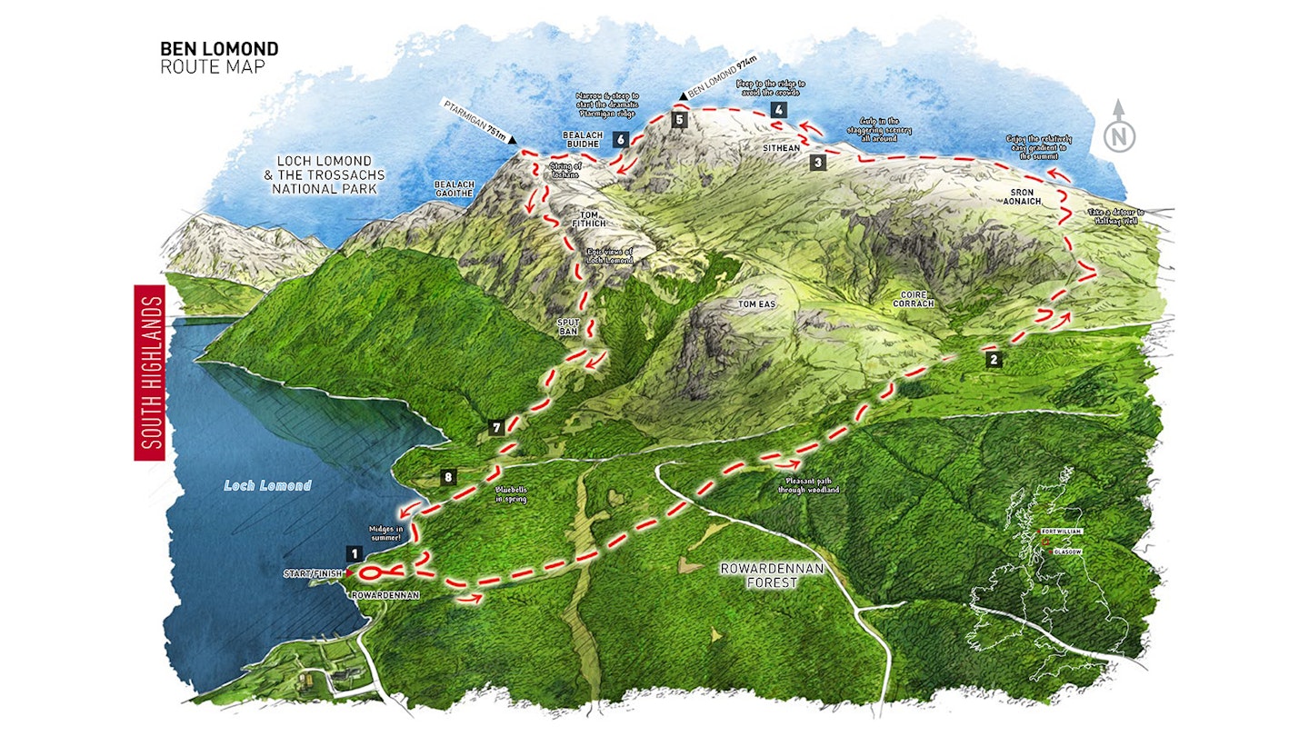
Map point 1 (NS359986) is a great place to start, particularly as there’s a car park there, not to mention toilets. It’s between a hotel and a hostel, so staying on this side of the loch shouldn’t be a problem, however deep your pockets. Once you’re ready, the first kilometre and a bit is through the Rowardennan Forest. Mostly a plantation, there are a few areas of deciduous woodland closer to the loch. I can remember in May seeing large areas of bluebells in open felled clearings. On that day, the flowers mirrored the blue of the sky; it was the stuff memories are made of. Once your brain is full to the brim with botany, let your boots do the work as you head up by a fence line, over a tiny footbridge or two, until you reach the glory of the open fells at map point 2 (NS371991). The path skirts the southern-most edge of Coire Corrach, in which can be seen another fragment of deciduous woodland.
Out onto the open, roughly north/south ridge and it’s time to get a few mountain miles under your belt. I love a good leg stretch and this section is certainly that. If you fancy a little distraction, then head off-path to have a look at Halfway Well. Although sitting at roughly half the height of the mountain, it certainly isn’t halfway to the summit from where we’re walking it from. Break the 700m contour line at map point 3 (NN373017) and look back over towards Loch Lomond.
To the west sits the distinctive, characterful profile of that ancient peak, the Cobbler. To the south, Loch Lomond broadens out. There’s even enough width for an island or 10. The main distinction in the view looking south, though, is the gap in the mountains. In fact they end, or start, depending upon how you look at it.
All that matters is you’re really up amongst the high mountain ridges now and all the wondrous views that go with being this high. I’ll let you into a little secret, I think Ben Lomond was my first Munro. It was my first Scottish Trail assignment, well over 20 years ago. Alas that day was claggy, the views had to wait for another time. That feature was shot in gritty black and white – definitely a mood piece.


Heading north above the 700m line, a zig and a zag soon plugs you into the south-east ridge. At map point 4 (NN372025) make sure you leave the path and keep to the crest of the ridge (as much as you are comfortable doing). The path misses out on one of the best parts of the day, presumably due to its headlong rush to get to the summit.
Well, between you and me, there’s plenty of time for the chaos of the top. Cop a load of the summit ridge and the way it leads around to the trig point. What’s more, check out Coire a’ Bhathaich, below you to the north; stonking. One day – and I’ve been saying this for many years – I’m going to climb Ben Lomond from the wilderness of the east, coming up the north-east ridge you are now stood at the top of. It looks like such a rewarding route up.
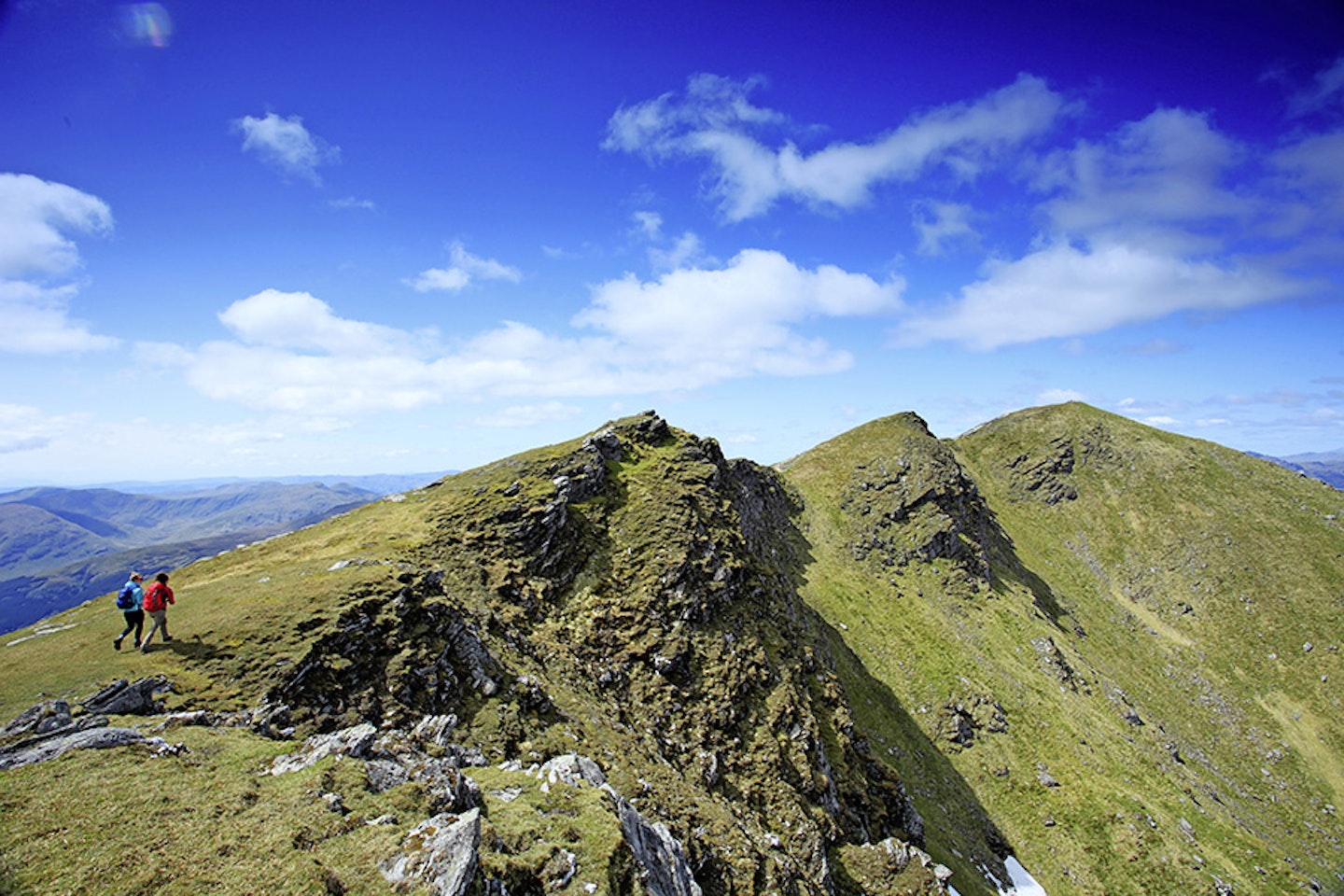
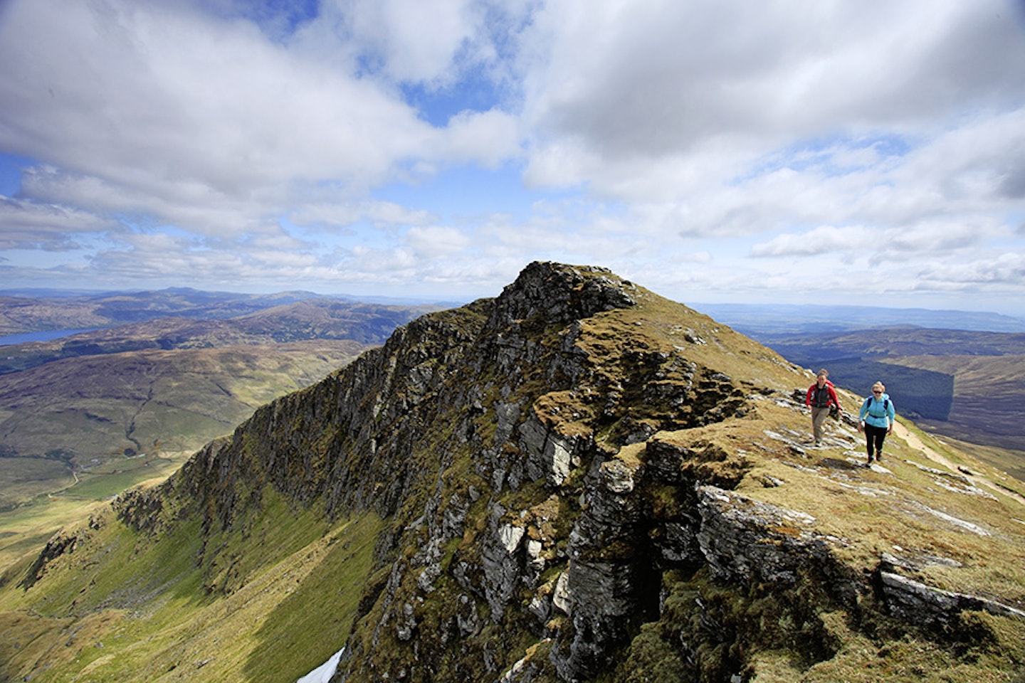
The summit ridge pretty much has three tops. Milk it for every ounce of fun, as this is the best bit of the high mountain and you’ll be away from the hoards for this section. Unfortunately, concrete trig points must be reached sooner or later. Once reached, at map point 5 (NN367028), this one looks like it has been gnawed by giant rock-eating rodents, with great chunks missing from its lower edges. For lunch, find a quiet spot a few metres lower down on the Ptarmigan ridge path, the one we’re going to be taking to the north-west.


The descent down the north-west Ptarmigan ridge is steepish, but perfectly do-able on an obvious path. Now, the reason for walking the route this way round may not appeal to those of you who like to walk up a steep, narrow ridge, but bear with me. As you face out, lift your head and drink in that view. I’m hurting just thinking of it.
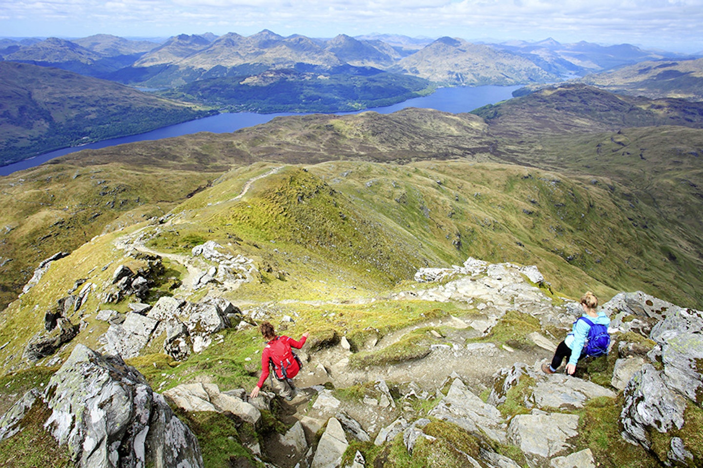
Loch Lomond just keeps going, on and on to the north. Then there’s range after range of hills, all the lesser-known mountains of this part of the world. If anything is going to set you up for a lifetime of Scottish mountain walking, then it’s this view.
At map point 6 (NN363031), the base of the ridge proper, now is the time to really relax into the rest of the Ptarmigan ridge. This route is such a snaking pleasure, it winds its way through smaller hummocks and around strings of lochans. There are sections of great square cut stepping stones. I remember getting a particularly atmospheric shot here on the shoot I previously mentioned, with the stones vanishing into eerie mist.
I guarantee this will be a happy descent. The lower you get, the more the loch seems to rise up to you, flooding the view with a level mirror to the sky. You really get a chance to study the southern skyline. There really aren’t many Scottish hills that you get to climb that don’t have mountains on all sides, and I know this sounds odd but enjoy sinking into a flat world as you head southwards. Even in its lower stages, the path keeps your interest. More woodland is skirted at map point 7 (NS361996), and bird species become more varied as the green of life wells up before you.
I think you can probably tell I like this walk. But in truth I don’t want to. I’m not one for popularity, it’s just not my thing. This hill is popular, but bloomin’ heck there’s a good reason for it. In the right conditions it is a great big, fat slice of mountain perfection.
Nearing map point 8 (NS360993), walk past Rowardennan Lodge Youth Hostel, in all its Victorian, imperialist grandeur, fight your way through the clouds of midges and make your way back to the car park. Dump your bag in the car and walk to the loch edge. Get those boots off and do what I told you to do at the start of the article. Does life get any better?


Fact file
WHERE DO I START?
At the car park at grid reference NS359986 on the eastern side of Loch Lomond. There are toilets at the car park.
WHAT’S THE TERRAIN LIKE?
A combination of very well-trodden paths on open moor and through plantations, as well as rocky sections and narrow paths on the Ptarmigan ridge.
HOW HARD IS THE WALK?
This is a straightforward mountain day. If you can climb Scafell Pike, then you can climb this fella.
WHAT MAP SHOULD I USE?
■ OS Explorer 39 (1:25k) ■ OS Landranger 56 (1:50k) ■ Harvey Superwalker XT25 Ben Lomond (1:25k)
WHERE CAN I STAY?
■ Rowardennan Lodge Youth Hostel ■ Inversnaid Hotel
Click here to download this walk of a lifetime route from OS Maps

Get HALF-PRICE digital Ordnance Survey Maps for the whole of Great Britain by subscribing to Trail magazine.
