Trail magazine’s 'Walks of a Lifetime' series takes you on a guided tour of the greatest mountain routes in Britain. This time we’re in the Lake District for a circuit of the Langdale Pikes, with experienced mountain connoisseur Tom Bailey as our guide...
Click here to download this walk of a lifetime route from OS Maps
I strongly advise you to approach the Langdale valley from the tiny road that comes over the pass near Blea Tarn, as the view of the Langdale Pikes just before you reach the tarn is among the best in the Lake District. Trees pepper the foreground, then that familiar outline of the Pikes rises like some fantasy kingdom. Continue driving over the pass and you’ll get a look into the northerly branch of the upper Langdale valley. I did it recently and was taken aback by the enormity of this part of the valley. We’re going to be walking back out through it. But first, let’s get started.
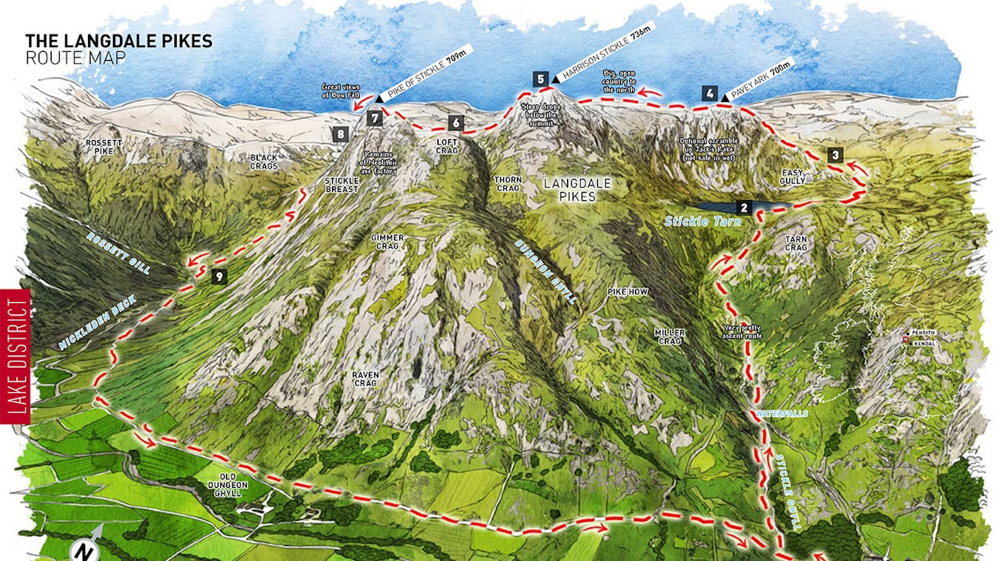
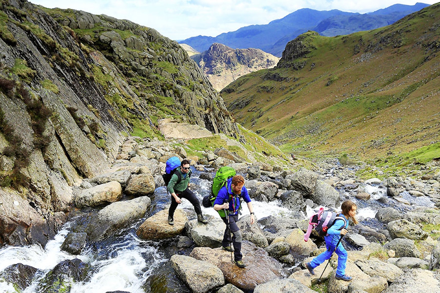
There are a couple of car parks near to the New Dungeon Ghyll area at map point 1 (NY295064). More importantly, there are a couple of pubs, so that post-walk tipple couldn’t be more conveniently placed. Parking here is at a premium come the busy periods, so get here early. The path winds behind the main NT car park up to Stickle Ghyll and follows this for the next 1.5km. This is one of the more pretty starts to a mountain day. In summer the stream here makes a fine ghyll scramble (wear a helmet), and being close to the car, you can get as wet as you like. If you’ve stayed close to the ghyll all the way up, then you’ll be forced to cross at some stepping stones, as the stream sits in a mini gorge. Gorgeous. Look back at any stage of this ascent for rewarding views of Lingmoor.
At map point 2 (NY288075) you’ll pop out at the dam end of Stickle Tarn. This was my first solo wild camp spot. It’s also where my son and I wild camped for the first time together. So I like it. Pavey Ark towers over the far side of the tarn. Here you’re faced with a decision. If you’re a keen scrambler, then Jack’s Rake (a very popular Grade 1 scramble, not great in
the wet) is the obvious left-hand slanting diagonal line up the face and the route for you. But I’m treating this day as a walk, because it’s a great walk. Some people may question whether this makes it epic enough to be classed as a ‘walk of a lifetime’, but my defence is that once you start looking and peeling back the layers of interest, there is always far too much to see and do in any walk.
So heading north-east around the tarn, the path will get a little boggy towards the top (north-east) end. Look for a left-hand split, one that’ll take you pretty much to the base of Pavey Ark’s north-east spur (map point 3, NY288081). The path up is fun and for the first time you feel as if you’re really high in the mountains. Definitely make the effort to stand on
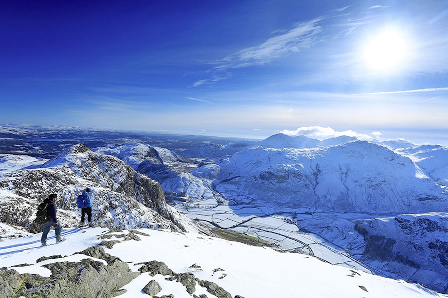
the rocky summit area (map point 4, NY284079), as the drop to the tarn and the view to the south-east look like pure Lakeland vistas. But turn around and look to the north. Here there are miles of high ground, well off the usual beaten track, interesting country; remember it. Although I haven’t included it in the map, you can easily detour out to Thunacar Knott from here with little exertion of energy. It doesn’t give you much extra, but if you like a sense of completeness, then go for it.


There’s a maze of paths across this high, almost plateau-like area, behind the Langdale Pikes. It’s a bit of a lost world really. Well, a lost world that everybody knows about, so I suppose I mean a hidden world. The next objective is Harrison Stickle (map point 5, NY281073). Choose whichever path suits you and enjoy the romp over these Lakeland lookers. In the past I’ve done a bit of a scramble up the east face of Harrison. I can’t say it was ace, but if you ever need a reason to do something a little different then give it a try (aim for the base of it from Stickle Tarn).
To get to Loft Crag, then the path cuts back to the west to keep a bit of height, before heading south and up to one of my favourite peaks in the Langdale Pikes (map point 6, NY279070). There’s a path that runs down the ridge to the south-east from here and returns to the car park. I can remember once being up here with my then wife and our two youngish kids. We’d had a great day, just this last descent to go. Well, energy levels had clearly run out by this point, no matter how many treats were issued. I can remember looking longingly at the pubs below, mouth watering, yet never seeming to get any nearer. I’ve never wanted a pint of beer more. Anyway, we’re not going that way, we’re heading for the Tunnock’s tea cake in the sky; Pike of Stickle.
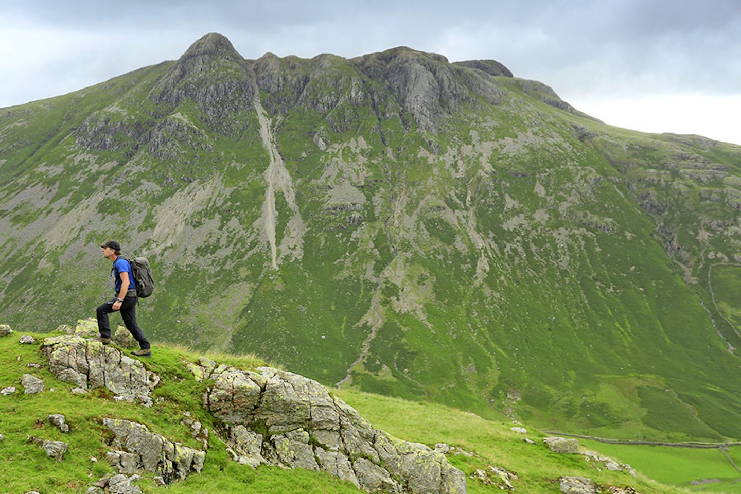
The path that connects Loft Crag and Pike of Stickle is for my money the best value of the day. Looking forwards and a little to your left, the upper Langdale valley looks epic and a long way down, even though it isn’t that far. It also looks like big mountain country. Bow Fell, to the south-west, seen from here looks scorchin’ hot for the first time in its life.
Through the Langdale Pikes runs a vein of volcanic ‘tuff’, a type of rock exploited by the Neolithic people around 5000 years ago. The Langdale Pikes is one of the places where the quarrying of this rock was at its most intense. As you pass the huge gully, just before you get to Pike of Stickle, take a few moments to gaze into it. If you think back to the times you’ve looked at the south-west face and seen that weeping scree fan leaking from the gully you’re now standing above, you might be surprised to know that a great deal of that scree is axe-making debris from the Neolithic quarrying process. Mind-blowing.
Pike of Stickle (map point 7, NY274074) is a true friend, as it gives you what you need at this stage of the day – a teeny little bit of a scramble, just to make the summit seem special. And my gosh it is. With that plunging neckline to the south-west it leaves no doubt as to who’s the hottest around here. Somewhere near the cairn inevitably makes the perfect lunch spot, and there’s enough space to find a quiet area should it prove busy. Bow Fell, Bow Fell, Bow Fell… wow, it looks huge and exciting, second only to the view of it from Upper Eskdale. As you sit, try to imagine the place 5000 years ago. The sound of voices, shouts and the knocking together of rocks as axes are ‘roughed out’, before being transported to a finishing site, often outside of the Lake District. Funny to think of that all going on.


That was all a bit of a frenzy; a fierce climb, then one hill after another, all the time keeping your head up so as not to bump into other walkers. The next part of the route loses the crowds and relaxes into an uninterrupted walk. The immediate foreground, as you head initially north-north-west from Pike of Stickle, has that empty hugeness that creates a sense of space. Familiar peaks fill the distant vista. These are the ones you often see Pike of Stickle from. Stake Pass is the next destination. The descent is easy to start with. Martcrag Moor awaits and this is where it all gets a little boggy. One thing I’ve learned, when walking this route in the opposite direction, is that there are some interesting views of the Langdale Pikes from around this area. Push a little closer towards the Langdale valley and they get even better, as you see the full sweep below the Pike, to the valley floor. It also gives an idea of the walk out.
Stake Pass (map point 8, NY265087) is a classic Lakeland pass. You could easily cut the corner and miss it out, but you’d be missing out. North from Stake Pass is the long, winding Langstrath valley. Drop into that and you pass right through the Lake District. This pass is that significant. Once I encountered a lone red deer stag here, not a common sight in the heart of the Lakes.
I like coming down this section of the Cumbria Way into the upper Langdale valley. The path follows Stake Gill down to the head of Mickleden Beck (map point 9, NY261073). A simple footbridge crosses the stream, a stream whose full potential can be seen in the non-vegetated boulders that fringe its banks. A sure sign of how much water these rivers carry when in spate.
A long, easy path stretches all the way back, so just relax and enjoy. What’s even better is that the first real sense of civilisation you’ll encounter is the Old Dungeon Ghyll Hotel, which has a bar with an interesting mountain-based interior and good beer. Another 1km further on and the car park is reached, along with Stickle Barn and the New Dungeon Ghyll Hotel. If I was making this walk the best it ever could be, then I’d stay in the campsite and visit all three pubs, twice…


Fact file
WHERE DO I START?
There’s several large car parks at the New Dungeon Ghyll area (grid ref NY295064).
WHAT’S THE TERRAIN LIKE?
Well made paths in places, stepping stones over streams and a short scramble (nearly) to the top of Pike of Stickle. A boggy section, so give gaiters some thought.
HOW HARD IS THE WALK?
A straightforward mountain walk, just requires a good sense of direction, if conditions are anything other than clear.
WHAT MAP SHOULD I USE?
■ OS Explorer OL6 (1:25k) ■ OS Landranger OL90 (1:50k) ■ Harvey Superwalker XT25 Lake District West (1:25k)
WHERE CAN I STAY?
■ NT Great Langdale Campsite ■ Ambleside YHA ■ The Old Dungeon Ghyll Hotel ■ The New Dungeon Ghyll Hotel
Click here to download this walk of a lifetime route from OS Maps

Get HALF-PRICE digital Ordnance Survey Maps for the whole of Great Britain by subscribing to Trail magazine.
