Trail magazine’s 'Walks of a Lifetime' series takes you on a guided tour of the greatest mountain routes in Britain. This time we’re in the Lake District to explore the complex Scafell massif, with experienced mountain connoisseur Tom Bailey as our guide...
Click here to download this walk of a lifetime route from OS Maps
The highest point in England, Scafell Pike, is a worthy prize. Combine it with its twin, Sca Fell, via adventurous and little travelled routes and you have a Lakeland classic. Sod it, you have a British classic.
There should never be any excuses, you should know ‘our’ main peaks from many perspectives. It’s easy to be complacent about the key mountains. Ben Nevis, Snowdon and Scafell Pike are peaks that over your hillwalking lifetime should become old friends, with every facet of their personality, both good and bad, linked to personal memories. This is a chance to get under the skin of England’s crowning glory. To look deeply into the face of the mountain and see your own reflected back.
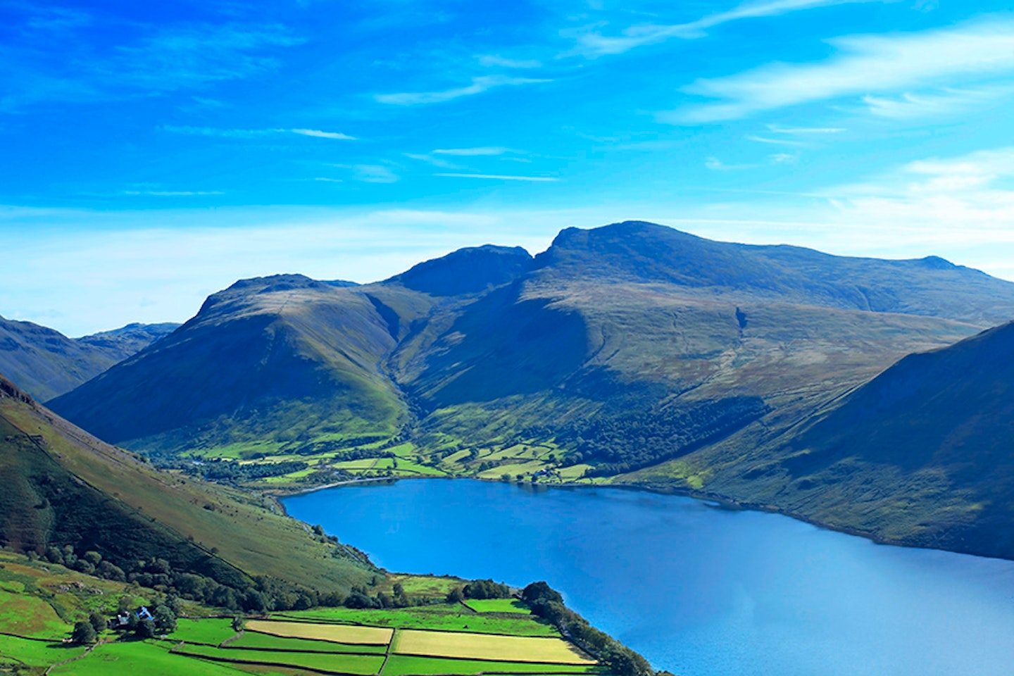
Wasdale Head is a pain in the bum to get to, but what a drive down the length of Wast Water. The view towards Great Gable, Kirk Fell and Yewbarrow, well that’s good enough to be incorporated in a logo. Oh, I forgot, it is – the Lake District National Park’s logo.
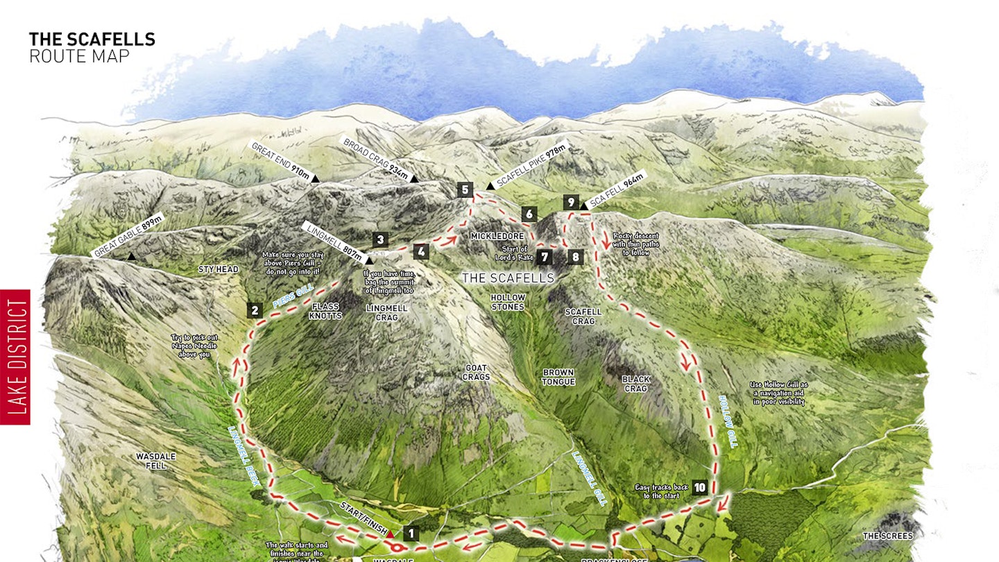
Park in the generous village green car park (map point 1, NY187085) where there is an honesty box. From this collection of fields and cottages the mountains rise on three sides, claustrophobically some might say. Once your kit has been checked and your pack is comfy, follow the distinct track in a north-easterly direction.
Soon you’ll come to St. Olaf’s church. Over 1000 years old and with Norse origins, it nestles amongst yew trees, closed in twice, by both them and the mountains. It’s worth a few minutes of your time to explore. Inside, etched onto one of the window panes, is a picture of Napes Needle, one of the first routes ever to be intentionally rock climbed. The farm is soon passed, and you’ll be following Lingmell Beck as it arcs around to the east.
Coincidentally Napes Needle will be directly above you on Great Gable to the north, it’s tricky to pick out from this angle but you’ll get some idea of the dramatic location. If you ever have the chance to get to it on the climber’s traverse, it is a great place to see our two mountains from.
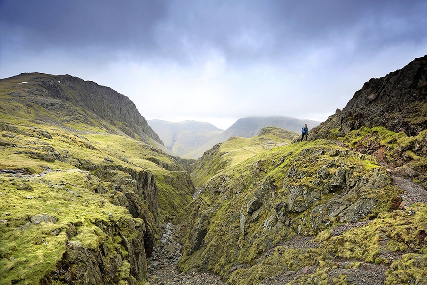
After fording Spouthead Gill, a junction in the paths is reached that is important to us (map point 2, NY214091). We’ll turn to the right, pulling up the fell, still keeping the main Lingmell Beck on our right. There are several streams to ford on this route, so pick a time when the rivers shouldn’t be in spate. We’re heading up by the side of (and this is a very important fact) Piers Gill. Do not go into it. I can’t over-egg this geological feature – a huge, deep, right-angled gorge, sat under the impossibly steep crags of Lingmell. The path climbs, dramatically close to the edge of the chasm. Once I heard the shrill, short but powerful voice of a wren’s song emanate from the depths of the ravine. From that pair of tiny lungs its song was amplified by the rock walls around it, making the tune mountainous. The path also passes over the wonderfully named Middlefoot Knotts.
It’s above this area that the Piers Gill path meets the main Corridor Route, as I’m sure you’ll know; a popular route to Scafell Pike. Looking back down Piers Gill from map point 3 (NY214079) is a sight to behold. Lingmell Crags are in full view, smoking hot. You’re surrounded by so much rock now, enjoy it, we’re about to elevate ourselves to the lofty heights of Scafell Pike.


The route climbs up to the col between Lingmell and the ‘Pike’ at map point 4 (NY211077). If you think today’s route is a little on the short side, then I highly recommend a little extra in the way of Lingmell as an out-and-back. If you stay close to the crags on your right, Piers Gill looks even better. But I digress, there is enough to do today for most of us.
The path to the summit takes a dramatic swing up to the south, climbing Scafell Pike proper. Things really start to change. Height is gained, along with expansive views. At a point where the path jinks violently to the south-west, notice that you’re on a long band of prominent rock. This makes a convenient stairway.
It is also the source material for the neolithic stone axes that were famously quarried from the Lakeland fells. It’s a volcanic ‘tuff’ that stretches for 19km through the area, and it appears to have been the places where it was near to the surface and high in the mountains where it was most enthusiastically quarried. The path climbs now over much loose rock, and you’ll be amongst the crowds. Enjoy them, ignore them, you won’t have them much past the summit. And it’s to the summit we go.
At map point 5 (NY215072) you’re on top of England! I hope your arms are outstretched, you’re facing the sun, chest puffed out, feeling like you could take on the world. Make the most of it. Once you’ve got your summit pic, escape the crowds by heading over to a detour that’s not on the accompanying map.
Let’s keep this one a little secret between you and me – the fewer people that know about this, the better. If you want great, plunging views over Lakeland without the hordes that the summit of Scafell Pike produces, then head to the south-east corner of the summit plateau. Here you’ll find a spot worthy of the very best mountain lunches. I’m not going to linger over the summit of ‘the Pike’ – I’m sure you’ve been there before. Have your fill, then we head south-west for Mickledore.
The path from the summit to Mickledore is less used these days, with the Corridor path being so easy and motorway-like. It leads to a stretcher box at the col (map point 6, NY210069). You stand at the door of Mickle. Do not attempt to climb Sca Fell from this point, we’re going down, before we come back up.
Head down the loose, wide, scree gully to the north-west. Looking to your west, you should shortly see a narrow gully, filled with scree (map point 7, NY208069). It’s up this we’re going, for it is the start of Lord’s Rake, a slashingly epic way up Sca Fell.

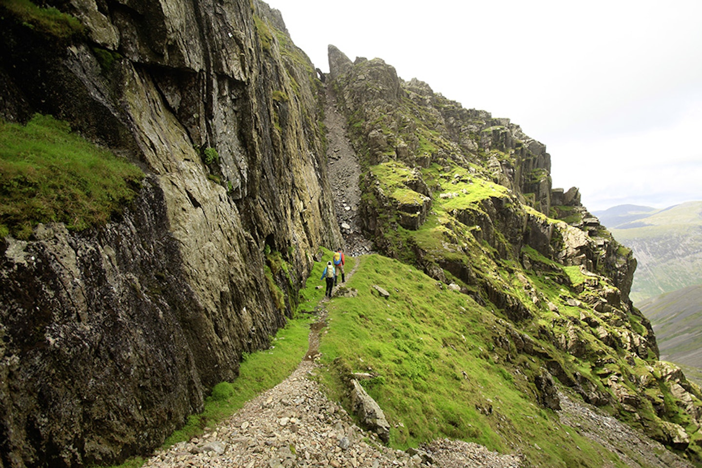

Until a few years ago, a dangerous looking block was balanced at the top of the gully, daring any who looked that way. Several times I clambered around it, or under it, I can’t remember which, but imagine my surprise when it finally did fall. After years of being warned it wasn’t a safe way up, guess what – it turned out it wasn’t. It’s gone now, so you only have all of the other dangers of the mountains to worry about. Lord’s Rake is worthy of its namesake. Once you are at the top of the tight gully, the path pitches and yaws with a roller coaster mentality, diagonally rising up the north face of Sca Fell.
It eventually pops out onto the broad, unflatteringly large buttocks of our second peak at map point 8 (NY205068). A south-east bearing from this point will take you up onto the summit ridge, a turn to the south-south-west will need to be made before the last 300m to the true summit (map point 9, NY207065), where a cairn and rock shelter mark the spot. Views north-east towards ‘the Pike’ take in something of its situation amongst Bowfell, Esk Pike and the like.
Leaving the summit of Sca Fell requires the old grey matter to be pressed into action. We’re heading generally westwards, where the path is thin at times over initially rocky terrain and consequently hard to follow. In mist I’ve used a compass to navigate this slope.
Easy-going once below the high rock, work your way towards Fence wood. Hollow Gill would be a convenient handrail if needed. I actually really like this flank of the mountain. Many an afternoon I’ve descended into the valley after a challenging day in the hills, warmed by the afterglow of physical exercise and the thought of a pint or two in the Wasdale Head Inn.
Once you’ve found the nick in the two woods at map point 10 (NY184067) the mountains are pretty much done with. An easily followable track leads past the National Trust campsite at this eastern end of Wastwater, then on over the river (the road may be a better option if there is much in the way of rainwater), back to the overgrown hamlet of Wasdale Head. What a fab day.


Fact file
WHERE DO I START?
The route starts and finishes in the public car park at grid ref NY187085 near Wasdale Head. Wasdale is one of the hardest Lakeland valleys to each by car, but well worth the long drive.
WHAT’S THE TERRAIN LIKE?
You get a real mixture of mountain conditions with this walk, including valley path, stepped path, river fords, boulder field, scree gully, moorland, steep rock and steep gully.
HOW HARD IS THE WALK?
The definition of a challenging hillwalk. There are no graded scrambles or particularly complex sections, but it’s rocky and long with plenty of points that need sharp navigation skills.
WHAT MAP SHOULD I USE?
■ OS Explorer OL6 (1:25k) ■ OS Landranger OL90 (1:50k) ■ Harvey British Mountain Map Lake District (1:40k)
WHERE CAN I STAY?
The Wasdale Head Inn is based at the start and finish of the route, with good food and rooms. YHA Wasdale Hall has private rooms and dorms, and the Wasdale National Trust Campsite is in a stunning setting.
Click here to download this walk of a lifetime route from OS Maps

Get HALF-PRICE digital Ordnance Survey Maps for the whole of Great Britain by subscribing to Trail magazine.
