Trail magazine’s 'Walks of a Lifetime' series takes you on a guided tour of the greatest mountain routes in Britain. This time we’re in the Lake District to walk the Coledale Horseshoe, with experienced mountain connoisseur Tom Bailey as our guide.
Click here to download this walk of a lifetime route from OS Maps
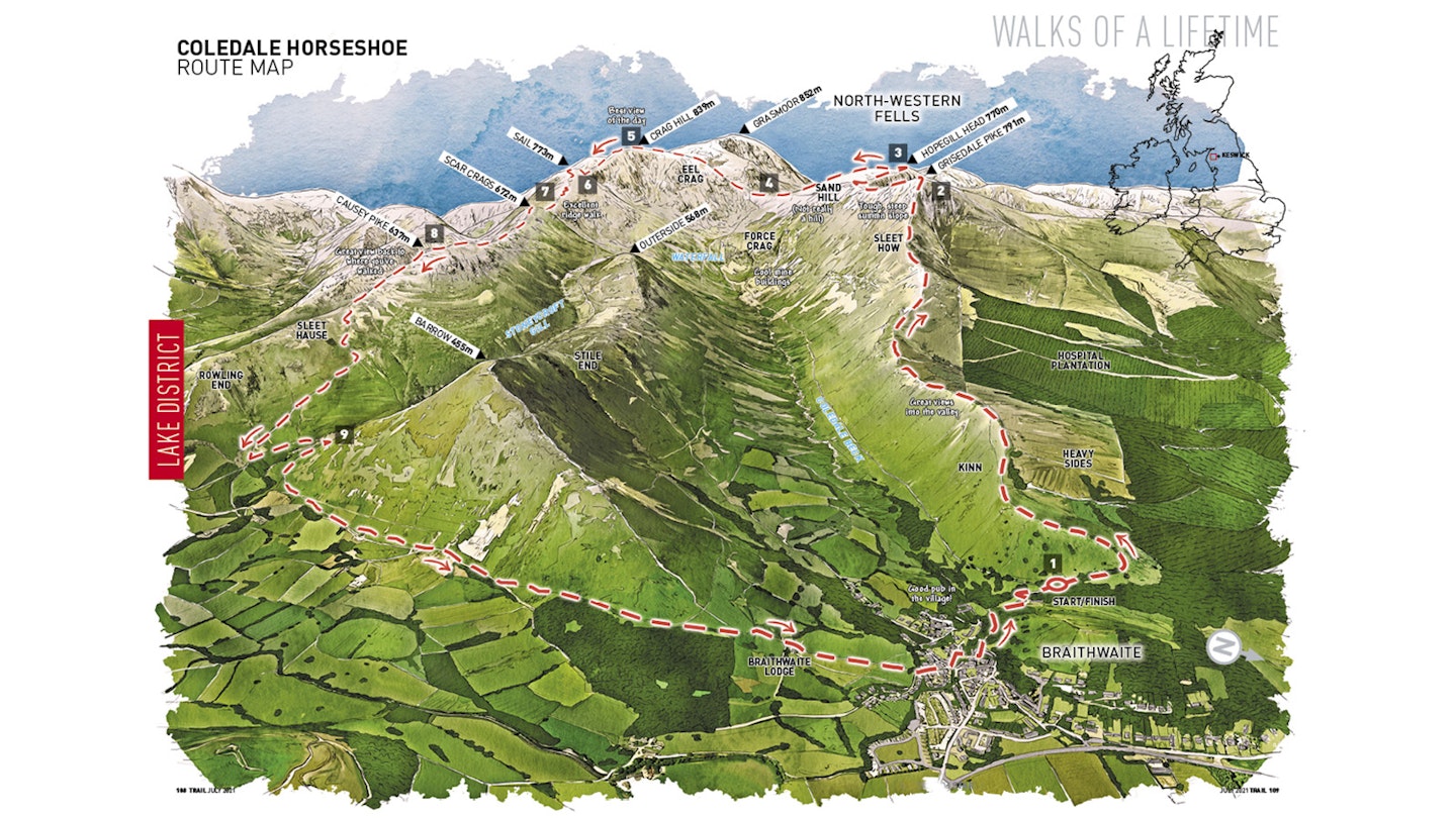
Braithwaite is a perfectly positioned picturesque village at the mouth of the Coledale valley, just a few miles west of Keswick, the town that rules over all in the northern Lake District. Coledale Beck, the river that this walk conspires to circumnavigate, flows straight through it, dividing it in two. You’ll have noticed all this, if you’ve passed through the village on the way to the starting point of the walk (map point 1, NY227237), at the bend in the B5292, better known as the Whinlatter Pass road.
There isn’t loads of parking here, so if you’re serious about what you do, do it well and get there early. This walk is an absolute smasher. I love it. Pure Lakeland perfection. Just right for those days when you need to have something go well and make you feel on top of the world. It’s even within easy bus reach of Keswick, so this might be one to save for that trip when you leave the car at home. My heart’s racing, let’s get going.
Steep ascent
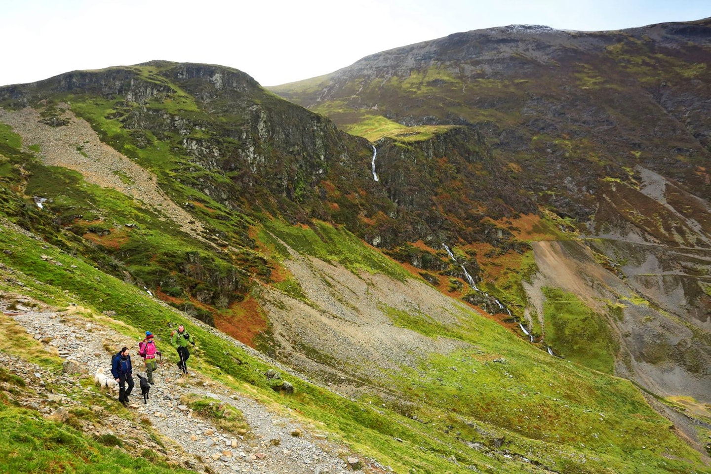
Grisedale Pike; I have a hate/hate relationship with it. By that, I mean I hate to hate it. It’s all to do with the route up it that I’m about to describe. From the summit of Grisedale Pike a ridge runs to the north-east, this is the one I’m talking about. On its lower reaches, above Kinn, it’s pleasant, giving far-reaching views into the Coledale valley, particularly into the knotty, crag-infested head of the valley, but more of that in a bit.
The problem comes once you’ve passed Lanty Well (a spring marked on the map), jinked a bit on the ridge, then re-aligned yourself for the real push for that pesky peak. The climb up Sleet How is initially straightforward enough, but Grisedale Pike now wants to play with you. It’ll give you a glimpse of what is surely the summit, then, on reaching it, it won’t be it. It does this several times.
This in itself isn’t anything unique, false summits are common in the mountains. It’s the gradient of the slope up the final climb onto Grisedale Pike that adds a whole level of pain to the mind-bending climb. What’s more, Grisedale Pike is a really great mountain. One that, once you know what it looks like (trust me, you’ll never forget once you’ve climbed it from this angle!) you’ll see from many surprising places. It’s a landmark hill, much like Causey Pike at the end of our route. So Grisedale Pike; I hate to hate you, but I just can’t help myself.
Of course the summit of Grisedale Pike (map point 2, NY199226) comes eventually, but not before you’ve paid the price. So why do this walk including this ascent? It’s worth it – really worth it – is my answer. It’s a great lump of a mountain day, with a bare cone of a summit. You’ll see Hopegill Head to the west-south-west of you and you’ll want to go there. Hobcarton Crags make it look devilishly nice, and are just a hop, skip and a jump away. But first take in Crag Hill’s Eel Crag towards the south-south-west and directly below you to the south Force Crag and its mine workings. Consider yourself warmed up.
Ridge walking
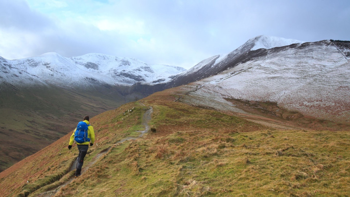
Trending south-west from the summit of Grisedale Pike (three ridges lead off GP – the one we came up to the east-north-east, another to the north, and the one I’m describing). Just less than 1km from it there’s a spot-height of 739m. Here you can take a racing line that avoids the next two peaks, but be warned, you’ll be poorer for it. So the path bends west, then rallies and goes for the summit of Hopegill Head in one curving rush, with none of the peculiarities of Grisedale Pike’s idea of fun.
There’s a point on this path where the crags look dramatic, particularly the ridge leading off to the north from Hopegill Head’s summit. At the top (map point 3, NY185221), you’ll look at that northerly ridge and make a vow, a vow to come back up it. I know because I did, many years ago, and I wasn’t disappointed.
The ridge between Ladyside Pike and where you’re standing on Hopegill Head is that good. Next comes Sand Hill, a bit of a cheat if you count this as a separate mountain, but hey, you decide. What it is good for is romping over and down to the col known as Coledale Hause (map point 4, NY189211). Definitely worth an explore to the east to get a closer look at the valley, but don’t lose too much height… This can be a windy place, as most wide cols can be, and there aren’t any tarns, so if you ever wild camp here you’ll have to search out one of the streams for water.
Rough terrain
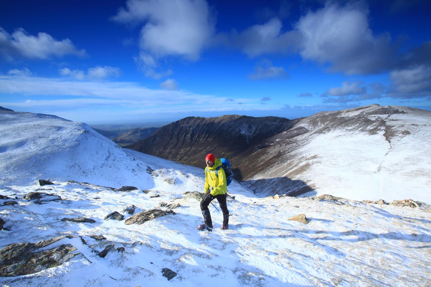
Now our route heads up the scree and boulders on the northern spur of Crag Hill. This is loose, ‘pain in the neck’ kind of terrain, so if you don’t like uphill scree slopes there is an alternative around the western side of Crag Hill. In my book, that route loses sight of the Coledale Valley and so doesn’t count! So, scree and boulders it is. As you climb, there are thin paths that snake up through the rubble.
Don’t drift round to the east too much onto Eel Crag, that wouldn’t end well. Around about the 800m contour line, the slope chills out and gets all horizontal. Now is the time to appreciate the views up the Coledale Valley to the north-east. In fact, I think this spot, before you get to Crag Hill’s summit, gives the best view of the valley. You’ll notice the valley is straight, yet within it the Coledale Beck meanders in a frenzied way while keeping a straight course. Appropriately enough, bearing in mind that you’re stood above Eel Crag, I think the river looks like an eel. Could this be where the name came from?
At the very top of Crag Hill (map point 5, NY192204), there’s a trig point and that’s about it. OK, so there are also loads of big views that’ll make you smile, after all this is the highest point of the walk. This mountain, Crag Hill, is a bit of a contrast to Grisedale Pike. Think about it… the Pike was a conical comedian of a mountain, while Crag Hill is overblown, convex and takes itself way too seriously!
The Scar
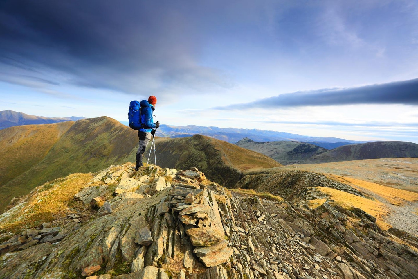
Slipping away to the east-south-east from this great ‘chocolate plateau’ of a mountain, a treat is in store in the shape of a shapely ridge known as The Scar. I was on this walk, or a version of it, a couple of weeks ago and three mountain bikes overtook me on the way to Coledale Hause. I last saw them heading up Crag Hill. All the way along The Scar, I followed their tyre treads in the patches of soil that linked with the rocky crest of the ridge. How they’d ridden that narrow fin of a ridge I’ll never know. I did keep checking to either side, to see if there was a tangled heap of mountain bikes and riders at the bottom.
The ridge makes its way up to the top of Sail (map point 6, NY198203), a healthy, plump mountain in the making, and a couple of rocks mark an approximate summit. That’s the real guts of the mountains climbed; the big stuff at the head of the Coledale valley. A zigzagging path descends initially to the north-east, before swinging more easterly, in a swerving, elegant manner. It’s welcome at this stage of the walk. The head lifts, and tired legs can relax on this easy section of the descent.
A shallow un-named col (map point 7, NY204205), provides the first proper view of the mine workings in the Coledale valley. They’re interesting in that they were active until as recently as 1991. That means the buildings are still there, a rare thing indeed. These building are primarily coated in a rusty corrugated iron covering, it looks like the set from a 1980s U2 video shoot. More seriously, the Force Crag Mine (because that’s its name) mined lead and rarer metals in the form of zinc and barytes for 130 years. The National Trust now owns it and runs tours a few times a year.
Huge views from Causey Pike

The ridgeline that leads up from the col in an east-north-east direction eventually gets you, in an effortless way, to Causey Pike (map point 8, NY218208).When you step up to the crown of this peak, take a deep breath before you turn and look back the way you came and a little further to the south, because this is a whopping great view. If you’re with friends, get a pic of them approaching you from the west. It’ll look impressive and they’re sure to buy you a drink to say thanks when you get to the pub in Braithwaite.
The photographer in me has remembered that looking in a westerly direction late in the afternoon will mean you’re looking into the sun, which means you’ll need a strong graduated ND filter on your lens. Or if you’re shooting on a smartphone, you’ll have to mess about with the image in ‘filters’ for quite some time. Whatever you do; get the picture. No-one ever takes enough actual walking shots, they tell you so much more than trophy shots at summits. Oops, mustn’t give away too many trade secrets...
The way back skirts Barrow’s eastern side, before sneaking into Braithwaite, conveniently close to the Coledale Inn, the perfect place for your friends to get you that drink. One from each of them wasn’t it?
Coledale Horseshoe factfile
WHERE DO I START?
At NY227237, a large lay-by on a bend in the B5292, or in the small car park a few metres further up the road.
WHAT’S THE TERRAIN LIKE?
Well-made paths on ridges that stay mostly out of bogs ensure normally dry feet. Steep climbs, loose boulders and scree in places, otherwise typical Lakeland paths.
HOW HARD IS THE WALK?
A degree of hill fitness is required for this one, as the hills come and go with an unrelenting regularity. Though having said that, the climbs aren’t huge. Straightforward for the experienced walker.
WHAT MAP SHOULD I USE?
OS Explorer OL4 (1:25k), OS Landranger 90 (1:50k), or Harvey Superwalker XT25 Lake District North (1:25k)
WHERE CAN I STAY?
Coledale Inn in Braithwaite, Keswick YHA, Blencathra Centre, Linnett Hill B&B in Keswick
Click here to download this walk of a lifetime route from OS Maps

Get HALF-PRICE digital Ordnance Survey Maps for the whole of Great Britain by subscribing to Trail magazine.
Need help with OS Maps? Try the OS Maps online FAQ and OS Maps quick start guide for further assistance
