Trail magazine’s 'Walks of a Lifetime' series takes you on a guided tour of the greatest mountain routes in Britain. This time we’re in the Lake District to walk the Bow Fell climbers’ traverse, with experienced mountain connoisseur Tom Bailey as our guide.
Click here to download this walk of a lifetime route from OS Maps
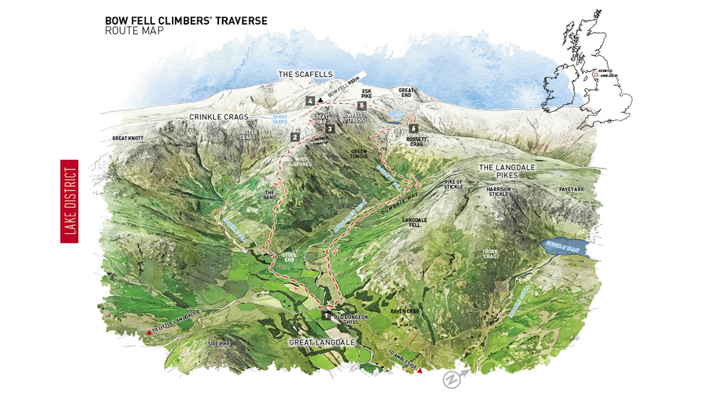
There’s an elephant in the dale, or rather a mountain. For when it comes to Langdale I’ll bet you think of the Pikes or Crinkle Crags before your mind turns to Bow Fell, which, let’s face it, is the elephant of Langdale when size is the deciding factor. For this is one chunky hill. All too often it’s included in longer routes, which diminish its glory. Of the Langdale clan, Bow Fell is undoubtedly the chief, and a chief needs to be shown respect. So do this walk, revel in it and pay your dues.
Parking at the Old Dungeon Ghyll (map point 1, grid ref NY286061), let’s accept the hand that Bow Fell, the sixth highest mountain in the Lakes, has laid down for us. Not quite a hand, more The Band, a two-and-a-half kilometre, broad, spewing ridge that heads to a col between Bow Fell and Crinkle Crags known as Three Tarns.
The path through the valley floor follows the access track for Stool End farm, the back of which butts up against the start of The Band and open access land. The ascent is steady, efficient. The Langdale Pikes to the north-east start to look mighty as you look them in the eye, but they’ll largely be behind you by the time you take a breather. And make sure you do, as they’re well worth a good stare. Up past White Stones, the path is clear and well-trodden, negotiating rock bands in its earlier sections.
At a split in the path by a cairn at (point 2, NY255061) take the right-hand option. This takes us over towards the northern edge of The Band, lining up for finding the true start of the Climbers’ traverse, which climbs above the path we’ve just left. Before that happens take a look around; to the south-south-east Pike of Blisco will go straight to the top of your ‘to-do’ list. West of you, the crown-like skyline of Crinkle Crags burns into your retinas. There’s no doubt you’re in the mountains.

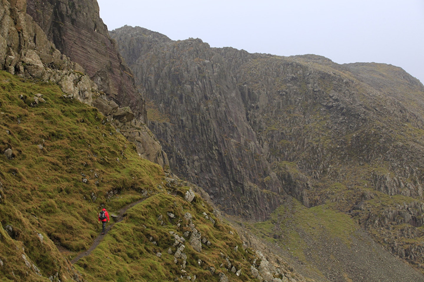

This path leads naturally to another cairn on the cusp of where the track slips around the north-east face of the mountain. The path is thin, winding away amongst the easy-angled, boulder-strewn mountainside. There is a feeling of approaching drama.
The ground steepens, Bowfell Buttress looms, but don’t be alarmed as we’ll turn away from it soon. Keep an eye and, more importantly, an ear out for the song of the ring ouzel. This is the blackbird of the mountains, with the male sporting a white ‘vicar’s’ collar. It loves steep rocky mountainsides, and you won’t forget the purity of its song echoing around the fells.
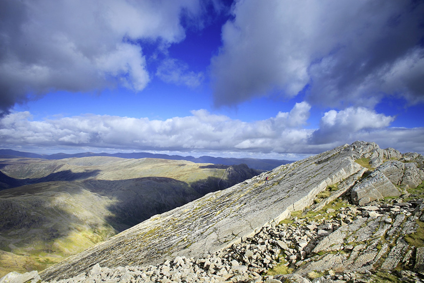
The path closes up to a steepening cliff above, squeezing between it and a large chunk of rock. It’s just past this first steep rock face that you turn up a shallow gully (point 3, NY246066). The entrance is broad and easy to see. This takes you up to one of the Lakes’ top geological features – the Great Slab. When you know what to look for, the Great Slab is visible from many of the surrounding mountains. It’s a real landmark. In amongst so much irregularity it just sits there, a perfectly flat, diagonally tilted chunk of rock.
But hold on a minute, let’s get there first. The gully is full of loose rock, easily ascended by keeping to the right-hand side. The slab is soon within sight and was right above you when passing under the cliff a few moments ago. If you simply want to look at the Slab, keep to your current line of travel. If, however, you fancy a more up-close-and-personal experience, then providing it’s not too wet or icy, the Slab sits at an easy enough angle to wander out onto. Just remember the cliff below. If you’re there with a friend, get them to photograph you alone on this immense piece of mountain architecture. You’ll look awesome. I remember climbing the gully in a snowstorm, the fresh snow ghosting into the cracks on the Slab, giving it a marbled appearance, only to melt away within the hour.


Once finished with the Slab, continue a short distance over easier-angled ground in the same southerly direction until you bisect the main Bow Fell path that comes up from Three Tarns. From here the summit beckons. The ground is strewn with boulders, the path is clear, but concentration is needed and once the summit crown is reached the line through the rocks is subtle. The final approach to the top is a short south-west leg until you reach the top (point 4, NY244064).
Bow Fell summit lacks a trig point, a fact I quite like, with just the merest hint of a rock nest by the cairn. Being a lofty mountain, the views are wide. Being near the middle of the Lake District, the fells are all around. Looking into the afternoon light towards the Scafells is my particular favourite, with the flat raised area above and behind the Langdale Pikes surprising in its enormity.
At 902m Bow Fell has a presence in at least three valleys. The Langdale valley is one, the wild Esk valley to the west is for the adventurous, and the approach along the Langstrath valley via Borrowdale is epic in its own right. Bow Fell from Crinkle Crags is a view worth seeking out, where the southern, upper flanks known as Bowfell Links give the mountain a shark-gilled look.
Head north-north-west for around 700m through high rocky terrain, where the views remain epic. Esk Pike flirts outrageously, but today will remain unclimbed. After a turn to the west, descending more rapidly, we’ll turn to the north in Ore Gap (point 5,NY240071). As its name suggests, iron ore is found here, breaking out of the surface of the path in numerous places. I can never resist picking up a little souvenir, brown in colour, with the heaviness giving its identity away.
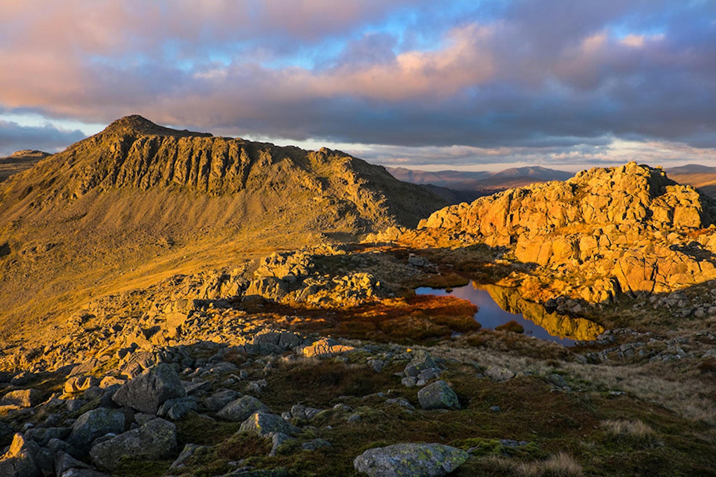
The path northwards from Ore Gap is thin, and Angle Tarn soon comes into view steeply below. As the path turns north-east you’re on a downward, curving line that meets one of the main Lakeland routes. Hang a right and the outflow of the deep, forbidding Angle Tarn is reached (point 6, NY245078).
Tucked right up against the northern cliffs (Hanging Knotts) of Bow Fell, in winter the tarn remains frozen for long periods. On the map it looks like an upside down, back to front comma. If you haven’t already, then this spot is the one to have lunch at. You can often tuck yourself away from breezes, looking up to the rock face above.
Moving on, take the path that heads south-west, heading uphill for a short while. Past Rossett Pike downhill is the agenda, so take the main track that veers more to the south. It swings away from another that stays in the gully bed – this one isn’t recommended. I usually break out the walking poles here, as the path zigzags before converging with Rossett Gill. The descent shallows up and you’ll soon be at the head of the Langdale valley. Cross the footbridge (point 7, NY261074) and join the Cumbria Way, heading south-east for 3km back to the Old Dungeon Ghyll.
The more I think about it, the more I realise Bow Fell really is one of the most significant peaks in the Lake District, with a mighty a presence that other loftier mountains lack. Bow Fell, you’re my new favourite.


Fact file
WHERE DO I START?
This walk starts from the car park beside the Old Dungeon Ghyll Hotel, near the head of the Great Langdale valley. The nearest town is Ambleside, 8 miles away by car on the shore of Lake Windermere.
WHAT’S THE TERRAIN LIKE?
This is a proper mountain route with a mixture of valley paths, steep rocky trails, rocky gullies, boulder fields, exposed cols and a broad, high mountain ridge.
HOW HARD IS THE WALK?
Technically not too difficult – it’s a rough walk rather than a scramble. The Great Slab is best avoided in very wet or icy conditions, because it can get slippy and isn’t something you want to start sliding down.
WHAT MAP SHOULD I USE?
The OS Explorer OL6 and Harvey Superwalker Lake District West maps cover the route at 1:25,000 scale. The OS Landranger 89 & 90 maps can be combined to cover the route at 1:50,000 scale.
WHERE CAN I STAY?
The Old Dungeon Ghyll and New Dungeon Ghyll Hotels are both good, as is the National Trust Great Langdale Campsite and YHA Langdale High Close, down the valley near Chapel Stile.
Click here to download this walk of a lifetime route from OS Maps

Get HALF-PRICE digital Ordnance Survey Maps for the whole of Great Britain by subscribing to Trail magazine.
Need help with OS Maps? Try the OS Maps online FAQ and OS Maps quick start guide for further assistance
