.jpeg?ar=16%3A9&fit=crop&crop=top&auto=format&w=1440&q=80)
Loughrigg Fell is a big hill. Not a tall hill, but a wide, sprawling hill, like a jelly turned out of its mould before it has properly set. Dolloped between Grasmere, Rydal Water, Ambleside and Windermere it’s an undulating lump that tops out at a modest 335m. So… why? In a nutshell, tarn-bagging.
“Tarn-bagging?”
“Yeah. Tarn-bagging,” Trail’s editor replied.
“Is tarn-bagging a thing?” It was not one I’d heard of.
“Yes. And if it isn’t, we should make it one.”
That’s more or less how the conversation went. Peak- or summit-bagging’s a familiar concept; but tarns? Really? In fact, tarn-bagging is already very much ‘a thing’, with several books and articles on the subject. That boat had sailed. But as an excuse to go exploring the Lakeland fells when vicious weather had put most summits out of bounds, it seemed as good as any.
Look at Loughrigg Fell on a 1:25,000 map, and among the swirling contours are seemingly random splashes of blue. Each one represents a body of water, but finding them on the ground is not easy. The top of Loughrigg is a maze of hillocks and troughs, and the pools hide among them. There is no one clear path, just several winding options that meander around and about. And there was a complication.
“When is a tarn a tarn?” Tom’s question threw me. “Sorry?” “When is a tarn a tarn, as opposed to just a big puddle?” It was a valid challenge. Lots of the pale blue patches on the map turned out to be well-defined tarns with an evident degree of permanence. But many of the others, we noted, weren’t on the map at all. Some just appeared to be hollows that had been filled by the copious amounts of rain over the winter. In the end we settled on a fairly basic system of tarn identification: if a pool was home to aquatic plant life, rather than soggy grass, it was deemed a tarn.
.jpeg?auto=format&w=1440&q=80)
So how does one ‘bag’ a tarn? With a hill, you stand on a summit; but must you swim in a tarn to claim it? Maybe; although we settled for dipping a hand in the water, or skimming a stone across its surface. But there are tarns all over Loughrigg Fell. By about the tenth we’d abandoned physical interaction with the water and were happy to tick off those we’d merely set eyes on. By the time we’d returned over the sagging pie crust of Loughrigg’s plateau, back up to the summit, and down the long and winding stone steps, the count was around 20 – and we were both somewhat disillusioned with tarns.
Simply bagging them was not, it seemed, enough. Certainly, when the next morning dawned wet and blustery, the thought of marching around a sodden fellscape picking off tarns by the dozen would not have shifted me from the comfort of Ambleside Youth Hostel’s recently renovated lounge area. The surroundings were warm, the coffee was hot, and Mumford & Sons played softly on the stereo. But we had a plan.
Scafell Pike is England’s tallest peak; there’s no disputing that. Around 130m below and 400m south-west of its summit lies Broadcrag Tarn, which, despite its name, is on the south slopes of Scafell Pike, not Broad Crag. Just shy of the 840m contour on OS maps, it is widely believed to be the highest tarn in the Lake District. But, according to internet rumours and speculation, it has a rival to that title.
Crinkle Crags is an amusing name for a fell. It’s the sort of place you wouldn’t be surprised to hear mentioned in an episode of Postman Pat. It’s the word ‘crinkle’. Nothing described as ‘crinkly’ can possibly be that intimidating.
.jpeg?auto=format&w=1440&q=80)
Under steely skies and billowing clouds, though, the crags felt rather less welcoming than their name suggests. Taunted by a niggling wind we set off from Wrynose Pass, which, if you’ve only ever heard the name spoken, you may be disappointed to learn is completely devoid of rhinos. Neither is Red Tarn red. The reflection of the cold, grey sky in its rippling waters gave the appearance of a vast lake of mercury, the diffused and shapeless reflection of Cold Pike barely discernible. Another tarn bagged, then; but not our quarry. Onwards we trudged, onwards and upwards. The sky had begun to change. The leadened clouds were warming and a tungsten yellow tinge infected the sky. Then the world opened up and we were staring down the barrel of Browney Gill, over The Band and to the Langdale Pikes beyond. It’s an imposing vista at the best of times. But with the clouds swirling, the world filled with strange light and the wind starting to roar, it was bordering on apocalyptic.
Near the top of Great Knott is another small tarn, unnamed on maps and almost out of sight from the path. The wind by now was constant and forceful; the sort of solid buffeting that’s like being pummelled by a mattress. Waves whipped across the water with such ferocity that the spray was hurled far from the shore and a doomed galleon would not have looked out of place slipping beneath the surface. A cold, desolate spot, but not our tarn. Up we went.
The highest point on the twisted summit ridge of Crinkle Crags is Long Top, and this is where the web-whisperers suggested the Lake District’s new highest tarn could be found. The infamous Bad Step scramble makes an exhilarating short cut to the summit; but when you’re having to fight to stand upright, any kind of hands-on is simply not an option. Instead we had to take a wide line out to the left before stalking back on to the summit of Long Top and taking our prey by surprise. And there it was. Another pool surrounded by rocks, the ink-black water churned to white in places by the ferocity of what was now a fully-fledged gale.
“Check the height!” Tom called over. I lay on my belly and held my GPS over the surface of the water. “843 metres!” I shouted back. “No, no. Hang on... 838.” “What’s Broadcrag Tarn?” “About 838.” “Close, then.” “Now the altimeter says 836. Wait, wait… 837. No, 839.” “So,” Tom said wearily, “we’ve established that this tarn may, or may not, be higher than Broadcrag Tarn.” I stood up and shielded my face from the horizontal rain. “Actually, I’m not convinced tarn-bagging is really for me.” Tom nodded, and we turned and headed away from the water.
Allow me, if you will, a moment of introspection. To earn a living, (among other things) I get to walk in amazing places with the only requirement being that I put the experience into words so I can share it with you. I am lucky and I know it. So, on our third day, given the prospect of hunting out yet another nondescript hole in the ground filled with water, what right did I have to feel miserable? Okay, so my knees and back ached from fighting against the wind; the very best weather we’d experienced had consisted of mild winds and light drizzle. But, hey, it still beats a day in the office, right? And, on the plus side, the weather was improving.
Indeed, as Tom and I headed into Grisedale, there were patches of blue. And in the sky this time, not just on the map. There were shadows on the hills as actual sunlight dappled St Sunday Crag. The previous day’s arduous endeavours were forgotten as we set our sights on something a bit special. The tarn we were hunting as our final hoorah was described by Wainwright as “a delectable place”. This splodge of blue even had a name, albeit one that suggested finding it might be easier said than done.
.jpeg?auto=format&w=1440&q=80)
According to Ordnance Survey’s OL5 sheet, Hard Tarn can be found high on the slopes above Ruthwaite Cove and below Nethermost Pike, on the 700m contour under the stony face of Nethermost Crags. There’s no obvious path to it so, after crossing the bridge, Tom and I left the wide, well-trod track that runs alongside Grisedale Beck. It was like stepping into a whole new Lake District. Gone were the exposed earth and traffic-polished stone paths. Now we were scrambling through grass and heather, hemmed in by moss-covered crags, and clambering over lichen-clad boulders. It was likely that each step we took was the first on that spot; and the feeling of walking in an undisturbed wilderness was one that’s unusual in the regularly swarming and occasionally sanitised Lakeland fells.
This contrast was brought into sharp relief within Nethermost Cove itself. It’s a wild place. It would be easy to believe no-one has set foot there before; a little lost world hidden among the folds of the Lakes’ famous landscape. Yet directly above the cove to the north is possibly the National Park’s busiest stretch of fellside – Striding Edge. After making a mental note to revisit on a wild camp, we continued up onto the west-east spur that separates Nethermost Cove from its neighbour and began the sweep around Ruthwaite Cove in search of Hard Tarn.
Hard Tarn is not as elusive as its name suggests. It’s just a question of getting as high on the slopes below Nethermost Pike as possible without the need for using hands and then traversing around the bowl until you stumble upon the small lake. Poised above a plunging drop to Ruthwaite Cove and held in situ by a sweep of bare rock, the tarn’s position is precarious but stunning. From the less vertigo-inducing shore, looking across its surface to the empty air beyond it with St Sunday Crag as the backdrop, Hard Tarn gives the illusion of an infinity pool. The crystal-clear waters present a perfect reflection of the sky, until the breeze wisps in over the cove, teasing the surface into gentle ripples.
I slumped down on a rock and looked around: “This I get. This was worth bagging.” “Another great spot for a wild camp,” Tom added, pointing at a small, flat patch near the water’s edge. He was right. Watching the sky and hills change in the light, the shadows of the clouds sailing silently over the valley below and playing on the sweeping hills around and the greying cornices above, it was difficult to believe that simply sitting there would ever lose its appeal. Hard Tarn had just become one of my favourite Lake District locations, yet 24 hours earlier I hadn’t even known it existed.
.jpeg?auto=format&w=1440&q=80)
And suddenly everything made sense: the reason people like tick-lists; the whole point of ‘bagging’; the continuing popularity of The Jeremy Kyle Show. No, no – scrub the last one; that show will never make sense. But the reasons for tarn-bagging were as crystal-clear as the water at my feet: discovery.
And thinking about it still further, it almost doesn’t matter what it is you’re bagging. Look for tarns, and you’ll find some awesome places with tarns. But go looking for something else and you’ll find those things in awesome places too. So do it. Do it now. Find something to collect, create a list and begin your bagging adventure. It could hand you a few unexpected gems along the way.
5 MORE ‘TARNS' TO BAG
LLYN LLYDAW, SNOWDONIA
Snowdon’s lake is allegedly home to the Lady of the Lake from Arthurian legend, though it does compete with Llyn Ogwen and Cornwall’s Dozmary Pool for that accolade.
RED TARN, LAKE DISTRICT
.jpeg?auto=format&w=1440&q=80)
If you follow the strict geological definition of a tarn (see below), at 718m Red Tarn is the highest in the Lake District. It’s also in a stunning location and well worth a detour on the way up or down Helvellyn.
DOXY’S POOL, PEAK DISTRICT
Found on the top of The Roaches in the Peak District, this pool is said to be bottomless and home to a water spirit who entices unsuspecting victims to their watery death by singing. We’re not convinced.
.png?auto=format&w=1440&q=80)
LOCH MAREE, HIGHLANDS
In Scotland’s Loch Maree (above) is an island. In that island is a lochan.
In that lochan is an island. It’s the only place in the UK that this island-in-a-lake-in-an-island-in-a-lake arrangement occurs.
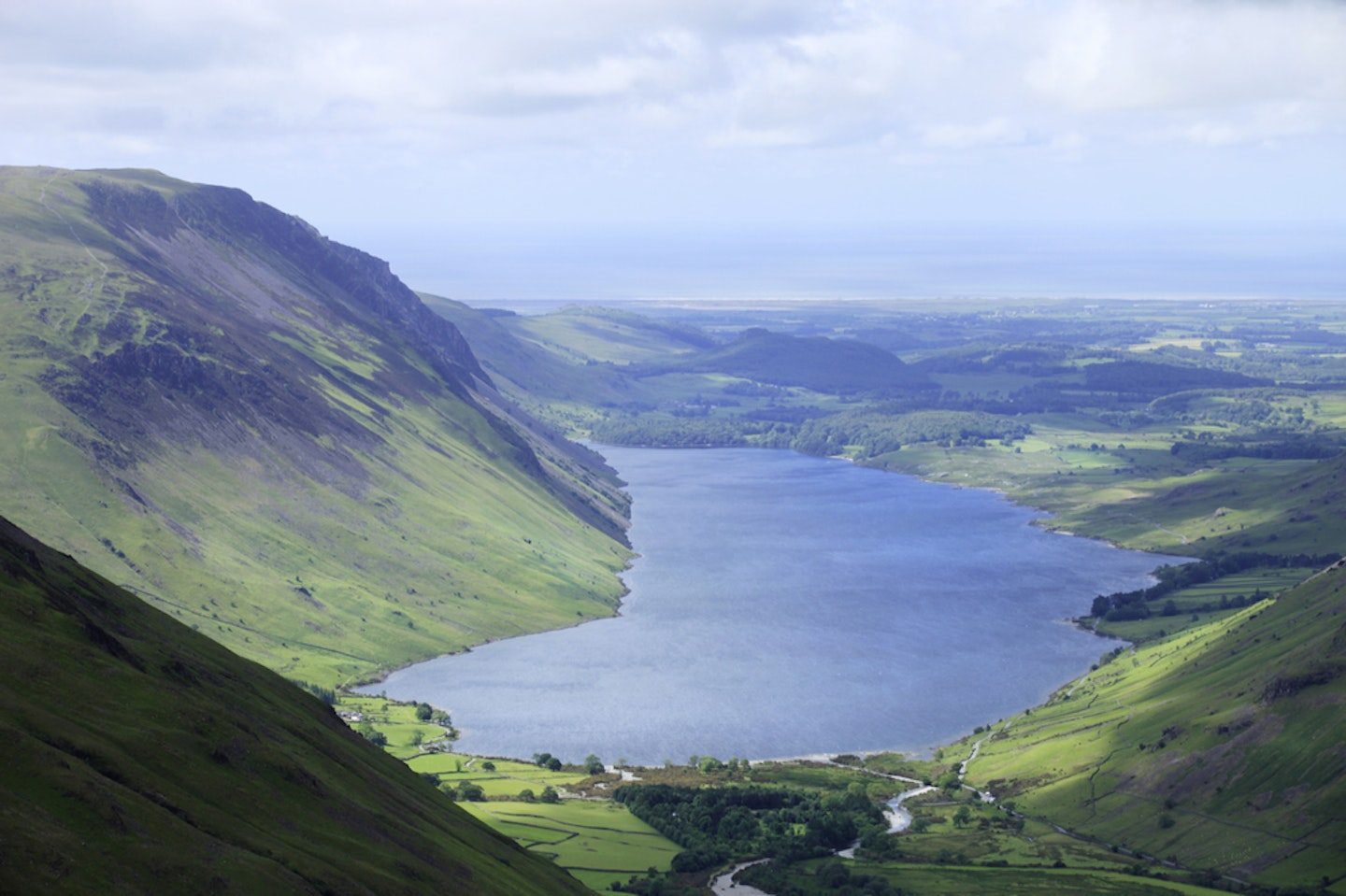
WAST WATER, LAKE DISTRICT
Wast Water England’s deepest lake at 79m, its surface is roughly 60m above sea-level, while its bottom is around 15m below.
It’s also home to an underwater gnome garden.
WHAT IS A TARN?
The word tarn comes from the Old Norse tjörn, meaning ‘hole filled with water’. This definition is still used in upland areas of northern England where the word describes any body of water regardless of location, such as Malham Tarn in North Yorkshire. Geologically speaking, the word has a more specific application and is used to refer to mountain lakes that have been created in a cirque left behind by the movements of a glacier; Red Tarn on Helvellyn and Scales Tarn on Blencathra are prime examples.
WORDS: BEN WEEKS